
Sotersta


Standing Stone(S) (Prehistoric)
Site Name Sotersta
Classification Standing Stone(S) (Prehistoric)
Canmore ID 339
Site Number HU24SE 6
NGR HU 26163 44638
Datum OSGB36 - NGR
Permalink http://canmore.org.uk/site/339


- Council Shetland Islands
- Parish Sandsting
- Former Region Shetland Islands Area
- Former District Shetland
- Former County Shetland
HU24SE 6 2616 4464.
(HU 2616 4463) Standing Stone (NR)
OS 6" map, Shetland, 2nd ed.,(1903).
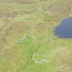
A large, irregularly shaped, sandstone block, 5'3" high by 3' 3" broad at base, standing on a knoll, with its main axis N-S. The stone has been incorporated in the west gable of a small building.
RCAHMS 1946, visited 1931.
Beside the stone recorded by the Commission, there are two others, the one 60yds., the other 80yds., from the first, the three being roughly parallel to the shore.
J Stewart 1957.
At HU 2615 4464 is the standing stone described by the Commission. The first stone mentioned by Stewart, at HU 2617 4462, is a large boulder, not a standing stone. The second of Stewart's stones at HU 2622 4461, is a rough upright stone c.0.7m high with a packing of stones at its base, and may be a standing stone.
Visited by OS (RL) 11 June 1968.
Scheduled as Sotersta, standing stone.
Information from Historic Scotland, 3 March 1993.
Field Visit (22 June 1931)
Standing Stone, Sotersta.
This large, irregularly-shaped block of sandstone, 5 ft. 3 in. high by 3 ft. 3 in. broad at the base, stands on a knoll at the S. end of the Loch of Sotersta, less than half a mile ESE of the Broch of Culswick (No. 1397), the major axis lying due N and S. Within recent years it has been incorporated in the W gable of a small building, and is thus not altogether easy to find.
RCAHMS 1946, visited 22 June 1931.
OS 6" map, Shetland, 2nd ed. (1903)

