
Pricing Change
New pricing for orders of material from this site will come into place shortly. Charges for supply of digital images, digitisation on demand, prints and licensing will be altered.
Battledykes, Oathlaw


Temporary Camp (Roman)
Site Name Battledykes, Oathlaw
Classification Temporary Camp (Roman)
Canmore ID 33667
Site Number NO45NE 12
NGR NO 45904 55493
NGR Description centred NO 45904 55493
Datum OSGB36 - NGR
Permalink http://canmore.org.uk/site/33667


- Council Angus
- Parish Oathlaw
- Former Region Tayside
- Former District Angus
- Former County Angus
NO45NE 12 centred NO 45904 55493
(NO 4591 5520) Ditch (R) (Site of)
(Centred NO 458 555) Roman Camp (R) (Site of)
OS 6" map, Forfarshire and Angus, 2nd ed., (1927)
The Roman marching-camp of Battledykes (Oathlaw) measures 1950' N-S by 3000' transversely, giving it an area of about 130 acres. In Roy's time (1755), three sides were almost entire and part of the fourth remained. Four gates were very distinct, and a fifth visible, but the traverse was levelled. Jamieson, writing in 1786, states that the camp appeared to have been defended on all sides by two ramparts with a ditch between except on part of the W side, where the marsh is. He also mentions a rampart which started at the SE corner of the camp, ran E for a short way, then S for c. 600', and turned W where it was lost after c. 360'. This rampart was not of any strength, and no ditch was visible.
When visited by Crawford (1949) in 1925 and 1939, the ramparts had been almost completely ploughed over, only a little over 500' of the S rampart, towards the W end, being visible, as shown on OS 6" map, while the ditch was only a cropmark. Nothing else of the S rampart, or of Jamieson's enclosure at the SE corner was seen. All of the ditch on the E side was seen as cropmarks, in the position shown on the OS 6" map, but hardly any traces of the rampart or ditch on the N or W were seen, though the raverse covering the eastern of the two entrances in the N side was located, consisting of a mound in the edge of the wood at NO 4598 5585. It is 20yds long, and the ditch to its N side is plainly visible. W of it, there is a bump in the road-hedge where the line of the rampart crosses it S of a cottage.
O G S Crawford 1949; W Roy 1745-55; J Nichols (ed.) 1780-90.
The only apparent remains of this camp is the traverse mentioned by Crawford (1949) at NO 4600 5586. It is exactly as described, being 21m long by 3.0m. The ditch to its N side is 1.5m wide by 0.3m deep and water-filled. At no other point were any trace of a rampart or ditch found. The short stretch in the wood at NO 456 551 comprises a modern drainage ditch, and the bank mentioned by Crawford here seems to have been formed by the cutting of the ditch. Certainly not a significant feature.
Visited by OS (JLD) 15 August 1958.
120 acres; Severan.
J K St Joseph 1969.
The camp lies on regularly cultivated land and all that can now be identified is the traverse or titulus noted by Crawford (1949). It extends from NO 4598 5585 to NO 4601 5586 and lies on the edge of a fir wood; it comprises a 1.3m high earthen bank with an 0.3m deep ditch on the N side as noted by OS (JLD) 1958. The bank has been mutilated on the S side by a modern road ditch.
Surveyed at 1:2500.
Visited by OS (TRG) 7 January 1977.
Note (1983)
Battledykes, Oathlaw, Temporary Camp NO 458 555 NO45NE 12
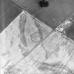
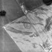
This temporary camp, which has been associated with the campaigns of the emperor Septimius Severus (c. AD 208-11), is situated on the S shoulder of the ridge separating the Lemno Burn from the River South Esk; it wholly encloses the home fields and steading of Battledykes farm. Roughly trapezoidal on plan, it measures a maximum of 930m from NE to SW by 630m transversely (c. 53ha). Titula have been recorded at five of the camp's six gates, the one situated opposite the easternmost gate on the NW side being the only part of the camp which is visible as an upstanding earthwork.
RCAHMS 1983
(Roy 1793, 66; St Joseph 1969, 118).
Publication Account (17 December 2011)
The camp at Battledykes, Oathlaw was one of the camps discovered by Captain Robert Melville while travelling through Strathmore in August 1754 (Balfour-Melville 1917: 123n; Jones and Maxwell 2008), and planned by Roy the following year (Roy 1793: Pl. XIII – illus 28). When Roy planned it, most of the NNW, ENE and SSE sides and part of the west were visible, along with five entrances, four of which were protected by tituli (Roy 1773). A later 18th-century account by the Rev. Jamesonof Forfar records an enclosure comprising a rampart of stones and earth with no ditch on the east part of the SSE side of the camp (1786: 18), and he likened this to the annexe at Kirkbuddo (1786: 20–1). No trace of this possible annexe has yet been detected in more recent times. Jameson also mentioned that the camp had two ramparts with a ditch in between, presumably reflecting the survival of a counterscarp mound outside the ditch (1786: 16). By the time that the site was planned by Crawford, part of the SSE side survived as an earthwork, along with a titulus on the NNW side (1949: 95–7). By 1958, all that remained of the camp was the northern titulus (OS Recorder 1958), which still survives close to the edge of a plantation.
The camp is located about 4km north of Forfar and 3km north of the probable camp at Lunanhead. It lies a few hundred metres from the Lemno Burn, in relatively flat terrain, although the area slopes gently to the northwest towards Wolf Law. Parts of all four sides have now been recorded from the air (illus 29), together with the titulus in the centre of the ENE side and a second titulus in the NN W side. It measures about 885m from ENE to WSW by 600m transversely, enclosing at least 51ha (126acres).
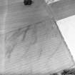
The upstanding titulus on the north side has been partially scarped to the south by the road, and the bank marking the edge of the plantation continues as a lower bank to the east and west of the mound. The titulus mound is about 19.2m long, 4.2m wide and 0.4m high. The ditch to the north is slightly shorter at 16.5m, and about 2m in width by up to 0.6m in depth.
At least one probable souterrain has been recorded within the perimeter of this camp (not depicted on illus 84, but see section 7h and illus 29).
R H Jones 2011

