
Eday, Sealskerry Bay


Castle (Medieval)(Possible), Settlement (Period Unassigned)
Site Name Eday, Sealskerry Bay
Classification Castle (Medieval)(Possible), Settlement (Period Unassigned)
Canmore ID 3218
Site Number HY53SW 3
NGR HY 5305 3195
Datum OSGB36 - NGR
Permalink http://canmore.org.uk/site/3218


- Council Orkney Islands
- Parish Eday
- Former Region Orkney Islands Area
- Former District Orkney
- Former County Orkney
HY53SW 3 5305 3195
See also HY53SW 4.
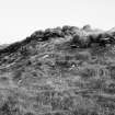
(Area: HY 530 320) An early stone structure of which nothing can be said without excavation, lies on the point of land at the west side of Sealskerry Bay (HY 53 31).
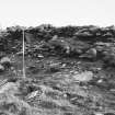
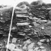
Some slight remains of masonry can be detected in the face of the bank on the site next to the open sea and in the same place there are traces of a small kitchen-midden deposit which produces fragments of mediaeval pottery.
A tall jar with handles, which sounds mediaeval, was found on the site by the tenant of a cottage nearby, but was destroyed.
Local tradition records the existence of a 'castle', a former proprietor's residence, in this neighbourhood, but it would be unsafe to associate it with the site in question as the rising ground behind Castlehill farm (HY 5360 3225) is a more likely site. (See HY53SW 4).
RCAHMS 1946, visited 1928.
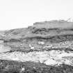
At HY 5305 3195 is an amorphous mound with its centre disturbed showing a stony content. This is locally believed to be where the 'jar' was found.
Where the shore is eroded to the W of the mound, traces of dry-stone walling with small midden deposits of animal bones and limpet shells are visible.
Unable to classify.
Visited by OS (RL), 23 July 1970.
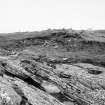
On the low but prominent point at the W side of the bay is an irregular knoll, being attacked by the sea; on its W side it exhibits much stonework and stone debris.
A complete pot apparently medieval, is recorded as having been found here, and there is a suggestion that this place was locally known as the 'castle'. (Pottery in the National Museum of Antiquities of Scotland [NMAS], HD 765-6).
RCAHMS 1984, visited October 1981.
Topographic and section recording was carried out at six coastally eroding sites, as part of a pilot programme to evaluate intermediate level responses to coastal erosion. Erosion of up to 17m has been recorded since 1881. Permanent markers were erected at five sites to assist in calculating future erosion damage.
HY 5305 3195 Settlement of possible medieval date. This site occupies a short peninsula of rocky ground and has been tentatively dated on the basis of the recovery of a pot from the vicinity, which was recorded as being of medieval type. Topographical survey indicated much buried stone and possibly walling centred on a low mound, although no structures were clearly visible. The remains of several linear features adjoining the NE site of the mound are thought to be remnant field boundaries. In the section exposure a drystone structure with angular walls and internal stone features, constructed over earlier midden-type deposits, was recorded.
Sponsor: Historic Scotland
G Wilson and H Moore 1996.

