
Dundee, Barrack Road, Dudhope Castle


Barracks (First World War), Barracks (Second World War), Castle (16th Century), Drill Hall (20th Century)
Site Name Dundee, Barrack Road, Dudhope Castle
Classification Barracks (First World War), Barracks (Second World War), Castle (16th Century), Drill Hall (20th Century)
Alternative Name(s) Dudhope Barracks
Canmore ID 31934
Site Number NO33SE 30
NGR NO 39459 30670
Datum OSGB36 - NGR
Permalink http://canmore.org.uk/site/31934


- Council Dundee, City Of
- Parish Dundee (Dundee, City Of)
- Former Region Tayside
- Former District City Of Dundee
- Former County Angus
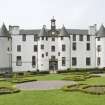
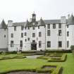
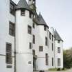
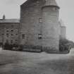
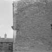
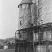
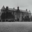
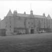
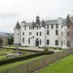
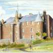
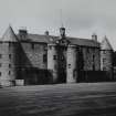
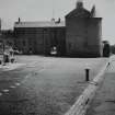
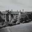
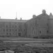
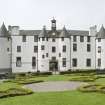
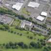
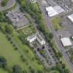
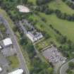
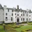
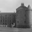
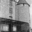
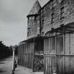
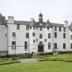
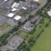
Late 16th/17th century, L-plan four-storey fortress and large tower house. It is rubble-built with angle turrets. The SW wing was built around 1588 with a vaulted basement, heightened in two stages; the pend section is dated 1600, the NE wing around 1684-9 on the site of the keep of 1460. Roof lines and floors altered 1792 and 1799 on conversion first to woollen manufactory, then, by Samuel Bell, to barracks. Restored and harled 1985-8.
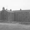
The building, having served as barracks from 1793 to 1880 was purchased by the Town Council in 1893 but was requisitioned for use in both First and Second World Wars.
Information from HS/RCAHMS World War One Audit Project (GJB) 12 September 2013.
NO33SE 30 3942 3067.
(NO 3946 3067) Dudhope Castle (NR)
OS 1:10,000 map, (1975)
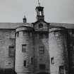
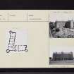
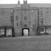
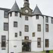
Duhope Castle measures c. 125' E-W over the towers by c. 120' N-S. It is designed on the plan of a central courtyard with buildings surrounding it, but only two sides of the quadrangle have been erected, the other two sides being formed by a wall which has now disappeared. The castle is 4 storeys high, though originally it was one storey less. The entrance gateway is in the centre of the E front between two drum towers. Belfry and gablet above the entrance are modern. The existing building is dated 1600 over one of the courtyard windows above the entrance passage, but some portions of the structure may be earlier than this as "the tower and fortalice of Dudhope" are mentioned ten years earlier. This, however, may refer to a previous structure, removed to make room for the present building. (Lamb, 1895, states that an earlier castle was known to exist in 1298; it was replaced in 1460 which was completely renovated in 1600.)
It was converted into a woollen manufactory at the end of the 18th century, and subsequently used as a barracks.
D MacGibbon and T Ross 1987-92; R L Mackie 1939; A C Lamb 1895.
Dudhope Castle is as described above. It is in a good state of preservation and in use as a club house. A plaque under the main entrance arch reads, "Dudhope Castle - erected end of 16th century on remains of original building 15th century Seat of the Constables of Dundee from circa 1298 - including Graham of Claverhouse, circa 1684. Military Barracks 1796-1879".
Visited by OS (J L D) 17 April 1958.
Though shown as roofed by Tranter, he states that the castle is suffering from neglect. He suggests that the orginal fortalice was probably an oblong tower, to which the wing was added. He (probably erroneously) gives the date inscribed over the window as 1660, not 1600. It has been much altered internally, and is not now in very good condition.
N Tranter 1962-70.
NO33SE 30.00 39459 30670
NO33SE 30.01 39464 30661
NMRS REFERENCE:
Dundee, Barrack Road, Dudhope Castle.
Plans: I.G. Lindsay Collection, W/441.
NMRS PRINTROOM
W Schomberg Scott Photograph Collection Acc no 1997/39
'Dudhope Castle'
'Officers Mess, Dudhope'
EXTERNAL REFERENCE
Scottish Records Office
Dundee. Theiking of the gallery at the house of Dudhope.
Receipted account from John & Wiliam Guild, slaters.
1673 GD 137/4138/11
Plasterwork at the House of Dudhope.
The work includes: His lordship's own study 'and round under it' The King's chamber, his lordship's dressing room, The Lady's bed chamber' and round', the diningroom, the hall, the new entry, his lordship's entry, the round above the pantry, the North chamber under the galleries and the lattermeat hall. Receipted account from David Milne, mason at Dudhope.
1673 GD 137/4138/15
Wright work at the House of Dudhope.
The work includes: roofing and sarking of the galleries, taking up old flooring of the old tower, relaying the floors, levelling of joists, lining of 6 windows with bound work - all of them being in the Hall, Dining Room, preparing chimneys and making door and windows.
Reciepted account from Robert Chrystall, Wright.
1673 GD 127/4138/16
Wright work at the House of Dudhope.
The work includes laying of the floors and making of doors and concerns: halls, dindingroom, innerchambers, my lord's study, gallery, my lady's chamber, 'Washing house with a fixed bed', cellars in trance, hawkhouse and door to bartisan head in lodging.
Reciepted account from Robert Chrystall, Wright
1673-1674 GD 137/4138/25
Accounts and reciepts for alterations and repairs undertaken for Lord Haltoune at the Houose of Dudhope.
Chamberlain: John Maitland
Mason: David Milne
Wright: Robert Chrystall
Slaters: John and William Guild
1672-1675 GD 137/4138/1-32
Photographic Survey (1959)
Photographs by the Scottish National Buildings Record in 1959.
Watching Brief (1992)
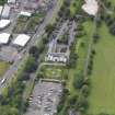
A watching brief was undertaken during environmental improvements. Below the existing courtyard area and adjacent road were layers of makeup containing 19th century pottery. Traces of former courtyard surfaces were observed. At the NW corner of the S wing of the castle two features were noted, a box culvert which may have brought water into the castle, and two aligned large flat slabs which may have been the foundation for the wall that was believed to have formerly enclosed the courtyard.
Sponsor: Dundee District Council.
Objective of Watching Brief
The objective of the watching brief was to record any archaeological remains revealed by groundworks necessary for landscaping, new pathways and drainage. In particular it was hoped to find the remains of earlier buildings relating to the castle and to determine if the courtyard had previously been enclosed by walls on the north and west sides. It was also hoped to find evidence of buildings and occupation predating that of the present castle.
Summary
Within the courtyard area the ground works revealed parts of a former courtyard surface. No remains of buildings were positively identified, although a make-up of demolition rubble below the former courtyard surface may have originated from such buildings. Two features of archaeological interest, F1 and F2, were recorded under make-up layers below a former courtyard surface. Feature 1 was an alignment of two stone slabs which may have formed part of the foundation for the west enclosing wall. Feature 2 was a rectangular stone built drain or conduit which was thought to date from the eighteenth or early nineteenth century. Dating evidence, supplied mostly by pottery sherds, indicated that the layers of make-up beneath the courtyard were nineteenth century.
In the area to the west of the castle beneath the road surface excavation for a pipe trench revealed deep rubble make-up layers and an unrecorded nineteenth century manhole and drain.
Information from SUAT
Photographic Survey (2010)
Photographed by RCAHMS on behalf of the Buildings of Scotland Trust.
Project (March 2013 - September 2013)
A project to characterise the quantity and quality of the Scottish resource of known surviving remains of the First World War. Carried out in partnership between Historic Scotland and RCAHMS.

