
Sanday, Elsness


Buried Land Surface (Period Unassigned), Unidentified Flint
Site Name Sanday, Elsness
Classification Buried Land Surface (Period Unassigned), Unidentified Flint
Canmore ID 306681
Site Number HY63NE 35
NGR HY 67263 39165
Datum OSGB36 - NGR
Permalink http://canmore.org.uk/site/306681


- Council Orkney Islands
- Parish Lady
- Former Region Orkney Islands Area
- Former District Orkney
- Former County Orkney
Field Visit (1999)
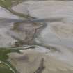
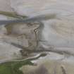
An old ground surface is exposed in intermittent patches in the intertidal zone on the northwestern side of Els Ness. It is most visible where the cobble cover has recently been washed away. It is occasionally covered by a thin deposit of peaty soil and can be seen to lie over a stony green till. The most extensive exposure measures 5m by 2m; the OGS is up to 0.25m deep. The surface of this deposit is cracked and fissured from the action of the sea. Traces of ashy deposits, which may be anthropogenic, and a fragment of struck flint were noted in association with this soil
Coastal Zone Assessment Survey, 1999

