
Westwards


Cup Marked Stone (Prehistoric), Stone Row (Neolithic) - (Bronze Age)
Site Name Westwards
Classification Cup Marked Stone (Prehistoric), Stone Row (Neolithic) - (Bronze Age)
Canmore ID 306170
Site Number NG44NE 28
NGR NG 45362 47975
Datum OSGB36 - NGR
Permalink http://canmore.org.uk/site/306170


- Council Highland
- Parish Snizort
- Former Region Highland
- Former District Skye And Lochalsh
- Former County Inverness-shire
Watching Brief (15 July 2008 - 11 September 2008)
Work was undertaken, 15 July–11 September 2008, during water main renewal. Site visits were conducted during trenching at the spur S through Glenbernisdale (NG 40347 58611 – NG 40284 48422) and a watching brief on the work from the Borve Service Reservoir to the A850–A856 junction (NG 44749 48344 – NG 45360 48002 – NG 45668 47854).
The desk-based assessment and walkover survey undertaken in September 2007 identified seven notable sites in the vicinity of the development at Borve and numerous footings of abandoned buildings, enclosures and dykes, either on the same alignment or further W of the spur S through Glenbernisdale. Prior to the 2008 work the proposed route of the pipeline was re-routed to avoid, where possible, these known township remains.
All three of the trenches monitored and recorded during this fieldwork were archaeologically sterile. The route of the pipeline trench passed in close proximity to eight structures. Whilst every effort was made to avoid compromising the visible archaeology, re-routing the trench lines on a number of occasions, there were three junctures at which the route of the new water main either truncated or abutted known remains. At NG 40347 48620, a partially remaining turf and stone field dyke (Feature 1) was truncated. At NG 45470 47875 a NNE/E aligned field dyke (Feature 2) was truncated. At NG 45723 47812, the trench abutted the remains of a structure (Structure 8).
Where the trench routes passed close to visible features and structures, rapid surveys and photographic recording were undertaken. Four features and eight structures were identified and are detailed below.
Feature 1) Glen Bernisdale Crofting Township (NG44NW 16) - The partial remains of a degraded field dyke at NG
40347 48620, measuring c0.25m in height and c0.6m thick. This turf and stone dyke runs E/W. In parts, two courses of unmortared, undressed wall cobbles are visible. The dyke is largely obscured by vegetation.
Feature 2) Borve Crofting Township (NG44NE 26). A NNE/E aligned field dyke at NG 45470 47875, measuring a
maximum of 0.8m high and 1.6m wide. The dyke is a turf and stone construction, from which much of the sub-structural stone appears to have been cleared. The remains when breached by the cutting of Trench 3 proved to be superficial and much degraded.
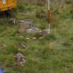
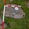
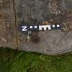
Feature 3) A row of boulders at NG 45362 47975, aligned NW/SE, consisting of 26 stones. It is 8.5m long x 1.2m wide and a maximum of 0.3m high. At the N end is a cup-marked stone measuring 0.66 x 0.44 x 0.15m. A single cup mark of 40mm, two natural fissures developed/pecked into channels and a possibly natural circular depression were noted.
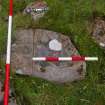
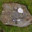
Feature 4) A cup-marked stone at NG 45158 47912, upon which two cup marks apparently aligned along a WSW/ENE axis are visible in the S half of the stone. To the E of the most WSW of the cup marks is a channel running E/W. It is not clear if this is a natural fissure that has been developed / pecked. The stone measures 0.55 x 0.49m. Additional, possibly natural, circular depressions are visible on the E quadrant and S half of the stone.
Five structures relating to the Glen Bernisdale Crofting Township (NG44NW 16) were recorded:
1) NG 40284 48422 A curvilinear platform, measuring 5.7 x 6.3m, with no obvious alignment.
2) NG 4026 4873 A curvilinear platform, with a radius of c3.5m. Partially surrounded with undressed cobble footings and recessed into a field dyke embankment to the W. Possible entrance to the ESE.
3) NG 40266 48465 A double-celled, N/S aligned, rectilinear structure. The turf and stone wall remains measure 4.5 x 5.8m and reach a maximum height of 0.3m. A 0.8m thick dividing wall of non-mortared, non-dressed cobbles occurs at 1.8m on the N side.
4) NG 40255 48452 A curvilinear platform, measuring 13 x 14.5m by 0.5m high, possibly N/S aligned, surrounded by a turf and stone embankment. External ditching is evident on the N, W and W faces.
5) NG 40263 48424 A double-celled rectilinear structure, W/E aligned. In some areas two courses of apparently
unmortared walling remain. Some large (0.5 x 0.22m) dressed stones remain in situ and measure 13 x 5m. An
internal dividing wall, 0.3m in height and 1m thick, occurs 6m from the E end.
Three structures relating to the Borve Crofting Township (NG44NE 26) were recorded.
1) NG 44731 48231 These L-shaped remains are c20m WNW of the Croft’s eastern boundary fence. The stone footings are turf-covered and measure 9 x 5m by 2m thick and 0.7m high.
2) NG 45162 47903 An ovoid platform with partially remaining stone footings, measuring 8.4 x 2.9m. The structure may have an E/W orientation. It has an apparent entrance at the E end and a less apparent interruption at the W. The structure measures 6.5 x 6.5m.
3) NG 45723 47812 The partial remains of a rectilinear structure. The remaining NNW and SSE faces measure 5.5m in length. The partially remaining undressed stone footings are 0.9m wide, 0.2m high and overlain with turf.
Archive: Highland Archaeology Services Ltd
Funder: Halcrow Group Ltd for Scottish Water
Cait McCullagh – Highland Archaeology Services Ltd
Note (30 May 2019)
Date Fieldwork Started: 30/05/2019
Compiled by: ScRAP
Location Notes: This stone was not relocated in the field despite an intensive search within a 60m radius of the grid references, and with the assistance of the farmer. The stone row in which the panel is located could possibly be the remains of a wall. Photographs of the stone were kindly provided by Highland Archaeology Services Ltd.
Panel Notes: The circular depression on the stone appears to be too straight-sided to be a cupmark, and may well be natural, but these observations can not be confirmed without seeing the panel.
Additional Description: Watching Brief (15 July 2008 - 11 September 2008)
Work was undertaken, 15 July–11 September 2008, during water main renewal. Site visits were conducted during trenching at the spur S through Glenbernisdale (NG 40347 58611 – NG 40284 48422) and a watching brief on the work from the Borve Service Reservoir to the A850–A856 junction (NG 44749 48344 – NG 45360 48002 – NG 45668 47854).
The desk-based assessment and walkover survey undertaken in September 2007 identified seven notable sites in the vicinity of the development at Borve and numerous footings of abandoned buildings, enclosures and dykes, either on the same alignment or further W of the spur S through Glenbernisdale. Prior to the 2008 work the proposed route of the pipeline was re-routed to avoid, where possible, these known township remains.
All three of the trenches monitored and recorded during this fieldwork were archaeologically sterile. The route of the pipeline trench passed in close proximity to eight structures. Whilst every effort was made to avoid compromising the visible archaeology, re-routing the trench lines on a number of occasions, there were three junctures at which the route of the new water main either truncated or abutted known remains. At NG 40347 48620, a partially remaining turf and stone field dyke (Feature 1) was truncated. At NG 45470 47875 a NNE/E aligned field dyke (Feature 2) was truncated. At NG 45723 47812, the trench abutted the remains of a structure (Structure 8).
Where the trench routes passed close to visible features and structures, rapid surveys and photographic recording were undertaken. Four features and eight structures were identified and are detailed below.
Feature 1) Glen Bernisdale Crofting Township (NG44NW 16) - The partial remains of a degraded field dyke at NG
40347 48620, measuring c0.25m in height and c0.6m thick. This turf and stone dyke runs E/W. In parts, two courses of unmortared, undressed wall cobbles are visible. The dyke is largely obscured by vegetation.
Feature 2) Borve Crofting Township (NG44NE 26). A NNE/E aligned field dyke at NG 45470 47875, measuring a
maximum of 0.8m high and 1.6m wide. The dyke is a turf and stone construction, from which much of the sub-structural stone appears to have been cleared. The remains when breached by the cutting of Trench 3 proved to be superficial and much degraded.
Feature 3) A row of boulders at NG 45362 47975, aligned NW/SE, consisting of 26 stones. It is 8.5m long x 1.2m wide and a maximum of 0.3m high. At the N end is a cup-marked stone measuring 0.66 x 0.44 x 0.15m. A single cup mark of 40mm, two natural fissures developed/pecked into channels and a possibly natural circular depression were noted.
Feature 4) A cup-marked stone at NG 45158 47912, upon which two cup marks apparently aligned along a WSW/ENE axis are visible in the S half of the stone. To the E of the most WSW of the cup marks is a channel running E/W. It is not clear if this is a natural fissure that has been developed / pecked. The stone measures 0.55 x 0.49m. Additional, possibly natural, circular depressions are visible on the E quadrant and S half of the stone.
Five structures relating to the Glen Bernisdale Crofting Township (NG44NW 16) were recorded:
1) NG 40284 48422 A curvilinear platform, measuring 5.7 x 6.3m, with no obvious alignment.
2) NG 4026 4873 A curvilinear platform, with a radius of c3.5m. Partially surrounded with undressed cobble footings and recessed into a field dyke embankment to the W. Possible entrance to the ESE.
3) NG 40266 48465 A double-celled, N/S aligned, rectilinear structure. The turf and stone wall remains measure 4.5 x 5.8m and reach a maximum height of 0.3m. A 0.8m thick dividing wall of non-mortared, non-dressed cobbles occurs at 1.8m on the N side.
4) NG 40255 48452 A curvilinear platform, measuring 13 x 14.5m by 0.5m high, possibly N/S aligned, surrounded by a turf and stone embankment. External ditching is evident on the N, W and W faces.
5) NG 40263 48424 A double-celled rectilinear structure, W/E aligned. In some areas two courses of apparently
unmortared walling remain. Some large (0.5 x 0.22m) dressed stones remain in situ and measure 13 x 5m. An
internal dividing wall, 0.3m in height and 1m thick, occurs 6m from the E end.
Three structures relating to the Borve Crofting Township (NG44NE 26) were recorded.
1) NG 44731 48231 These L-shaped remains are c20m WNW of the Croft’s eastern boundary fence. The stone footings are turf-covered and measure 9 x 5m by 2m thick and 0.7m high.
2) NG 45162 47903 An ovoid platform with partially remaining stone footings, measuring 8.4 x 2.9m. The structure may have an E/W orientation. It has an apparent entrance at the E end and a less apparent interruption at the W. The structure measures 6.5 x 6.5m.
3) NG 45723 47812 The partial remains of a rectilinear structure. The remaining NNW and SSE faces measure 5.5m in length. The partially remaining undressed stone footings are 0.9m wide, 0.2m high and overlain with turf.
Archive: Highland Archaeology Services Ltd
Funder: Halcrow Group Ltd for Scottish Water
Cait McCullagh – Highland Archaeology Services Ltd

