
Drumrack


Bench Mark (19th Century), Milestone (19th Century)
Site Name Drumrack
Classification Bench Mark (19th Century), Milestone (19th Century)
Canmore ID 305749
Site Number NO50NW 52
NGR NO 54202 08328
Datum OSGB36 - NGR
Permalink http://canmore.org.uk/site/305749


- Council Fife
- Parish Crail
- Former Region Fife
- Former District North East Fife
- Former County Fife
Field Visit (5 August 2010)
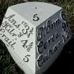
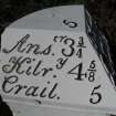
This milestone is situated on the N side of the B940 public road at Drumrack. It comprises a dressed sandstone block measuring 0.41m square by 1.05m in height. The SE side of its triangular cast-iron cap indicates the distances of 6 miles to Peat Inn, 9¾ miles to Ceres and 12½ miles to Cupar. The SW side indicates the distance of 3¾ miles to Anstruther, 4 and five-eighths miles to Kilrenny and 5 miles to Crail. On the flat upper surface of the cap there is the number ‘5’. There is an Ordnance Survey benchmark on the SE face of the stone, which is first depicted on the 2nd edition of the OS 6-inch map (Fifeshire 1893, sheet XV.SE).
Visited by RCAHMS (JRS) 5 August 2010.

