
Edinburgh, Blackford Hill


Rig And Furrow (Medieval) - (Post Medieval)
Site Name Edinburgh, Blackford Hill
Classification Rig And Furrow (Medieval) - (Post Medieval)
Alternative Name(s) Hermitage Glen, Hermitage Braid
Canmore ID 293232
Site Number NT27SE 5977
NGR NT 25220 70498
NGR Description Centred NT 25220 70498
Datum OSGB36 - NGR
Permalink http://canmore.org.uk/site/293232


- Council Edinburgh, City Of
- Parish Edinburgh (Edinburgh, City Of)
- Former Region Lothian
- Former District City Of Edinburgh
- Former County Midlothian
NT27SE 5977 centred 25220 70498
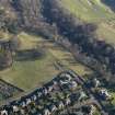
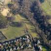
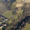
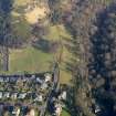
An area of rig and furrow cultivation has been identified from oblique aerial photographs (RCAHMS 2008) on ground bounded by Hermitage and Midmar Drives, the Hermitage of Braid and Blackford Hill. The rig cultivation mainly trends in a NW to SE direction with a small area to the N running ENE to WSW.
Information from RCAHMS (DE), March 2008.

