
Seton Mill, Mill Lead


Lade (18th Century)
Site Name Seton Mill, Mill Lead
Classification Lade (18th Century)
Alternative Name(s) Seton House
Canmore ID 292510
Site Number NT47NW 90.01
NGR NT 41689 75177
NGR Description From NT 40687 74085 to NT 41595 75894
Datum OSGB36 - NGR
Permalink http://canmore.org.uk/site/292510


- Council East Lothian
- Parish Tranent
- Former Region Lothian
- Former District East Lothian
- Former County East Lothian
NT47NW 90.01 from 40787 74085 to 41595 75894
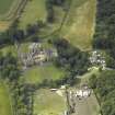
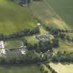
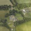
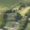
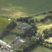
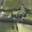
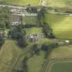
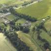
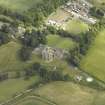
The Mill lade (lead, leat) supplying power for Seton Mill has been identified from oblique aerial photographs (RCAHMS 2007), running through the grounds of Seton House (NT47NW 3.00).
The Mill Lead is depicted on the 1st edition of the OS 6-inch map (Haddingtonshire, 1854, sheet 9) enetering the grounds at the SW corner and exiting at Seton Mill (NT47NW 90.00). The lade runs from a point near Meadowmill farmstead (NT 40787 74085) to the sea at Links Road, now part of the Seton Sands Caravan Park.
Information from RCAHMS (DE), Janaury 2008
Field Visit (9 February 1923)
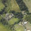
The17th century rubble garden wall terminates at the four angles in rounds or look-outs averaging 13 ½ feet in diameter and 12 ½ feet in height; on the south-west round a sundial, formed from a skewback removed from the collegiate church, is inset; the upper and under surfaces being wrought as dials. Tracery details from the church lie on the north terrace. Over the stream and north-north-west of the house are remains of 17th century buildings, apparently a dam and sluice serving Seton mill; at base remains of three massive piers or cutwaters can be traced, while in the upper partare windows of the period. On the left bank of the stream south-west of the church are remains of buildings known as the ‘priests' houses’, but the masonry is apparently of the 17th century; a few yards southward are traces of a large gateway c. 1620.
RCAHMS 1924, visited 9 February 1923.
Archaeological Evaluation (March 2009 - December 2010)
A Cultural Heritage Assessment was undertaken to assess the potential impacts from the construction of Blindwells New Settlement, Tranent. The assessment included a desk-based study and a reconnaissance field survey of the area.
CFA Archaeology (G. Mudie, M. Hastie) 2010

