
Cancelled


No Class
Site Name Cancelled
Classification No Class
Canmore ID 288340
Site Number NT73SW 408
NGR NT
Datum OSGB36 - NGR
Permalink http://canmore.org.uk/site/288340


- Council Scottish Borders, The
- Parish Kelso
- Former Region Borders
- Former District Roxburgh
- Former County Roxburghshire
NT73SW 408 7204 3384
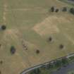
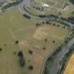
Two linear parchmarks interspersed by a scatter of pits, which run parallel from NW to SE and are situated to the NW of the River Teviot, have been recorded on oblique aerial photography (RCAHMSAP 2006).
Information from RCAHMS (VLW) 26 March 2007
Cancellation
Cancelled: The pits and linear features visible on the aerial photographs are described in NT73SW 20.

