
Seton West Mains


Settlement (Prehistoric)
Site Name Seton West Mains
Classification Settlement (Prehistoric)
Canmore ID 285913
Site Number NT47NW 214
NGR NT 40835 75109
Datum OSGB36 - NGR
Permalink http://canmore.org.uk/site/285913


- Council East Lothian
- Parish Tranent
- Former Region Lothian
- Former District East Lothian
- Former County East Lothian
NT47NW 214 40835 75109
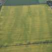
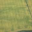
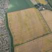
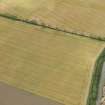
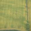
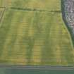
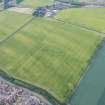
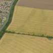
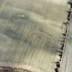
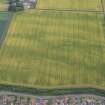
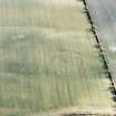
This settlement is situated on near-level ground about 450m NNE of Seton West Mains and has been recorded as cropmarks on aerial photographs (RCAHMSAP 2004; OS 77 109 frame no. 002, 6 August 1977). The settlement, which is sub-oval on plan and measures some 100m by 65m overall, is enclosed by a broad ditch with two external palisade trenches visible on the exterior to the S, E and N and an internal palisade trench forming part of a circuit. All the visible circuits of palisade trench run roughly parallel to the line of the broad ditch. The entrance is probably on the WSW, where the terminal of the broad ditch on the S extends beyond that on the W. On the ENE is a gap in the line of the ditch flanked by large post-holes, may be another entrance. There is a possible round house in the interior. To the S of the settlement enclosure there is a broad ditch, which extends for about 50m roughly parallel to the S side of the settlement.
Information from RCAHMS (MMB) 22 May 2006

