
Pricing Change
New pricing for orders of material from this site will come into place shortly. Charges for supply of digital images, digitisation on demand, prints and licensing will be altered.
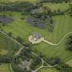
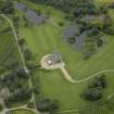
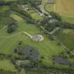
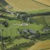
Menie Estate


Estate (Period Unassigned)
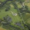
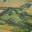
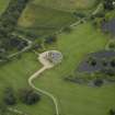
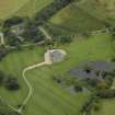
Site Name Menie Estate
Classification Estate (Period Unassigned)
Canmore ID 285174
Site Number NJ92SE 115
NGR NJ 98323 20616
Datum OSGB36 - NGR
Permalink http://canmore.org.uk/site/285174


![Watching brief, Lithic scatter [006] (= Flint Area A), Trump International Golf Links](http://i.rcahms.gov.uk/canmore/l/DP00305300.jpg)


![Watching brief, Lithic scatter [006] (= Flint Area A), Trump International Golf Links](http://i.rcahms.gov.uk/canmore/s/DP00305300.jpg)


- Council Aberdeenshire
- Parish Belhelvie
- Former Region Grampian
- Former District Gordon
- Former County Aberdeenshire
Excavation (June 2009 - July 2011)
NJ 99 21 Archaeological fieldwork was carried out at Trump International Golf Links at Menie Estate, before and during the construction phase. The fieldwork took place between June 2009 and July 2011 and comprised fieldwalking, survey and excavation. The fieldwalking identified the location and extent of two large and several minor flint scatters within the dune slack. The fieldwork also identified a former storm beach, largely buried in windblown sand, c150m inland from the current shoreline. It comprised a deposit of beach pebbles at the foot of a low eroded cliff. Several of the pebbles were flint nodules eroding out of the basal till. A programme of flint collection was carried out on two areas measuring 10 x 20m and 2 x 20m in the vicinity of the storm beach. There was a clear concentration of struck flints within both areas but none of these was associated with any features. A few retouched blades from the assemblage were identified as microliths indicating a Mesolithic date for the flint scatters.
Archive: RCAHMS
Funder: Trump International Golf Links
Magnar Dalland, Headland Archaeology Ltd
2012

