
Newtongrange, Station Road, Newtongrange Station


Railway Station (20th Century)
Site Name Newtongrange, Station Road, Newtongrange Station
Classification Railway Station (20th Century)
Alternative Name(s) The Waverley Line; Edinburgh To Hawick Branch Railway
Canmore ID 283857
Site Number NT36SW 191.06
NGR NT 33192 64244
Datum OSGB36 - NGR
Permalink http://canmore.org.uk/site/283857


- Council Midlothian
- Parish Cockpen
- Former Region Lothian
- Former District Midlothian
- Former County Midlothian
NT36SW 191.06 33192 64244
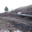
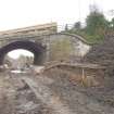
Nothing survives in a shallow cutting of Newtongrange Station except two metal rail posts on the down (W) side. These may have supported a sign.
The station was built in the early 20th century, not as part of the Edinburgh to Hawick branch railway.
Opened in 1908 after the expansion of the surrounding collieries, particularly the Lady Victoria and closed in 1969.
Visited by RCAHMS (DE), July 2006; R J V Butt 1995
Field Visit (April 2009 - February 2015)
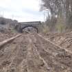
The Borders Railway Project proposals are to reinstate the Newcraighall to Tweedbank section of the former Waverley Line. The reinstated railway line will be approximately 48km long and the majority of the route will use the existing railway embankment.
Several field surveys, archaeological evaluations and standing building surveys were undertaken by CFA Archaeology from April 2009 until February 2015.
CFA Archaeology
Watching Brief (October 2012 - September 2014)
A programme of archaeological works was requiring during the construction phase of the Borders Rail Link. This included standing building surveys and targeted watching briefs.
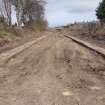
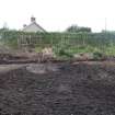
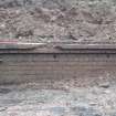
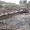
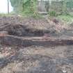
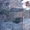
A watching brief was conducted at the location of the former Newtongrange Railway Station (NT 33191 64311). Sections of the platform on both sides of the track survived largely complete to the original track level, though the station itself had been largely demolished. Some brickwork, probably relating to the station buildings, survived in situ up to 5 courses high. The building remains were covered over and preserved in situ.
Funder: BAM Nuttal
CFA Archaeology Ltd
OASIS Id: cfaarcha1-188511

