
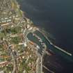
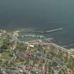
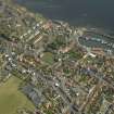
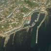
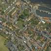
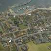
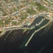
Pittenweem Harbour, South East Breakwater


Breakwater (Period Unassigned), Pier (Period Unassigned)
Site Name Pittenweem Harbour, South East Breakwater
Classification Breakwater (Period Unassigned), Pier (Period Unassigned)
Alternative Name(s) East Pier
Canmore ID 281071
Site Number NO50SW 71.01
NGR NO 54874 02224
NGR Description NO 54874 02224 to 54941 02335 to c. 55063 02441
Datum OSGB36 - NGR
Permalink http://canmore.org.uk/site/281071


- Council Fife
- Parish Pittenweem
- Former Region Fife
- Former District North East Fife
- Former County Fife
NO50SW 71.01 54874 02224 to 54941 02335 to c. 55063 02441
Pier [NAT] (at NO 55030 02405)
OS (GIS) AIB, May 2006.

