
Edinburgh, High School Yards, Early Concrete Road


Road (Period Unassigned)
Site Name Edinburgh, High School Yards, Early Concrete Road
Classification Road (Period Unassigned)
Alternative Name(s) Infirmary Street; Royal High School
Canmore ID 278814
Site Number NT27SE 5931
NGR NT 2615 7348
NGR Description NT c. 2615 7344
Datum OSGB36 - NGR
Permalink http://canmore.org.uk/site/278814


- Council Edinburgh, City Of
- Parish Edinburgh (Edinburgh, City Of)
- Former Region Lothian
- Former District City Of Edinburgh
- Former County Midlothian
NT27SE 5931 c. 2615 7344
(Location originally cited as NT 26155 73485). [Edinburgh]: early concrete road: corrected to NT c. 2615 7344.
Information from Prof R Paxton, Sept. 2005.
The location assigned to this record remains unverified, and may be plotted within the area of High School Yards, close to or beneath the former Royal High School (NT27SE 1578).
Information from RCAHMS (RJCM), 13 February 2006.
Construction (1873 - 1910)
Now covered over
Project (2007)
This project was undertaken to input site information listed in 'Civil engineering heritage: Scotland - Lowlands and Borders' by R Paxton and J Shipway, 2007.
Publication Account (2007)
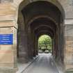
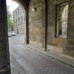
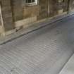
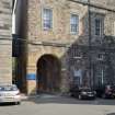
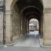
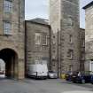
Early Concrete Road (High School Yards): The use of concrete in road construction in Scotland was pioneered by Joseph Mitchell with a section of concrete carriageway on George IV Bridge laid from 1866 to 1870 which proved successful. From ca.1873 to 1910 concrete carriageways totalling 5.5 miles were laid in over 100 Edinburgh and Leith streets under the direction of David Proudfoot, City Road Surveyor. Some are still in service but are now covered over. They consisted of a rolled stone bottoming on which a 412 in. thick layer of 112 in. whin road metal was uniformly spread and then grouted with a mixture of fine gravel riddled out of Fisher Row gravel and Robin & Co’s best Portland Cement. Their cost was about 40% of a road laid with granite setts. Maintenance costs were low, Blackwood Crescent, for example, involved a total expenditure of only £40.00 from 1873 until 1920. At High School Yards the original concrete surface was still visible until recently.
R Paxton and J Shipway 2007
Reproduced from 'Civil Engineering heritage: Scotland - Lowlands and Borders' with kind permission of Thomas Telford Publishers.
Excavation (March 2013 - May 2013)
NT 26151 73477 A programme of archaeological work was carried out, March – May 2013, during development work. The area of the Old High School is of interest as an earlier building, the 16th-century Royal High School, was demolished to make way for its construction. It was also the speculated location of a Dominican Friary founded in 1230 and demolished during the Reformation in 1559.
Since 2010 Headland Archaeology Ltd has been involved in the renovation of the Old High School with the work including a watching brief, historic building recording and an excavation. The watching brief revealed limited evidence of buildings to the rear of the Old High School and a number of culverts to the front of the building. The excavation was located near the entrance of the building and contained the remains of the Royal High School, as well as part of the Dominican Friary and associated graveyard. In total 95 burials were excavated, including one which had an elaborately carved grave slab.
Report: RCAHMS (intended)
Funder: The University of Edinburgh
Ross Murray, Headland Archaeology Ltd, 2013
(Source: DES)

