
Following the launch of trove.scot in February 2025 we are now planning the retiral of some of our webservices. Canmore will be switched off on 24th June 2025. Information about the closure can be found on the HES website: Retiral of HES web services | Historic Environment Scotland
Dubrach


Corn Drying Kiln (Post Medieval), Head Dyke (Post Medieval), Lime Kiln (Post Medieval), Still (Post Medieval)(Possible), Township (Post Medieval)
Site Name Dubrach
Classification Corn Drying Kiln (Post Medieval), Head Dyke (Post Medieval), Lime Kiln (Post Medieval), Still (Post Medieval)(Possible), Township (Post Medieval)
Alternative Name(s) Mar Lodge Estate; Glen Dee; Dubh-bhruach; East Dalvorar
Canmore ID 27755
Site Number NO08NW 9
NGR NO 0284 8874
Datum OSGB36 - NGR
Permalink http://canmore.org.uk/site/27755


- Council Aberdeenshire
- Parish Crathie And Braemar
- Former Region Grampian
- Former District Kincardine And Deeside
- Former County Aberdeenshire
Observation (1987)
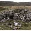
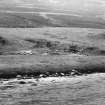
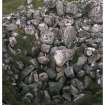
Settlement. At base of terrace bluff below the main settlement, an 8m diameter lime-kiln complete with entrance lintel. Adjacent, longhouses 10m by 4m and 8m by 4m. An enclosure with a 12m by 8m longhouse at each end, all close to the head-dyke. A separate group near the fan apex - outside the head-dyke - includes a longhouse, 12m by 4m, and another 17m by 5m. A substantial enclosed area is split into two by a less substantial partition wall. The main settlement consists of longhouse, 6m by 4m, a longhouse, 20m by 6m, partitioned into two, with a 6m by 4m structure tacked on at end. A 10m by 5m longhouse is attached to an older 8m by 5m structure at its eastern end. There are several small plots and stone clearance heaps. A 10m by 6m rectangular foundation with a complete kiln sits apart from the main complex. A solitary longhouse, 10m by 4m, sits on the bluff top, and one other also 10m by 4m. There are stone clearance and tipped stone festoons at the bluff edge.
J S Smith 1987
Field Visit (22 July 1993)
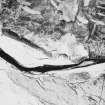
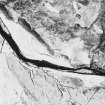
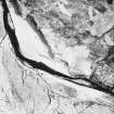
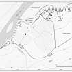
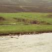
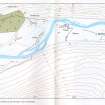
This township, on the S bank of the River Dee, consists of nine buildings, two kilns and a possible still, all within and around an area of cultivated ground enclosed by a head-dyke, together with a further four buildings and a hut beyond the head-dyke on the heather moorland to the S and SW.
Most of the structures within the head-dyke are situated on a terrace above the river bank. Of the nine buildings, seven (MAR93 579-80, 582-3, 590-1, 594) measure between 9.5m and 11.8m in length and between 2.5m and 3.3m in breadth within coursed-rubble walls up to 1.2m in thickness. The other two buildings are considerably smaller, measuring 5.4m in length by 3m in breadth (MAR93 584) and 6.2m in length by 2.5m in breadth (MAR93 593). All nine have rounded corners. One building (MAR93 583) has a substantial outshot at each end, giving it an overall length of 28m, otherwise these are all single-compartment structures. The only evidence for more than one phase of construction is to be found at MAR93 582, whose ENE end overlies a structure at least 10.5m long built on a slightly different alignment.
One of the kilns is situated on the terrace above the river (NO 0290 8874; MAR93 581), the other is located below the terrace at the back edge of the haughland (NO 0274 8873; MAR93 595). The former has a bowl 2.5m in diameter and a barn on the N side. The bowl of the other kiln is also 2.5m in diameter, but there is no trace of a barn; it has a flue 1.6m long bridged by a substantial lintel. The position and more massive construction of the latter kiln suggests that it may have been for lime burning, while the kiln on the terrace was for drying grain.
In a secluded position on the E bank of a burn, at NO 0268 8862, in a narrow gully towards the W edge of the township there is a hut measuring 4.3m in length by 2.4m in breadth within walls 0.8m in thickness. This may have been an illicit still (MAR93 592).
Buildings MAR93 590 and 591 form the SE and NW sides of a small enclosure, a second enclosure is attached to the NW side of building MAR93 583, and there is a third to the E of building MAR93 582. There is a pit in the last of these, and another pit lies just outside it, to the S: these may have been for storage.
The head dyke encloses an area of about 12ha, about half of which is on the terrace above the river. There is rig over the W half of this higher ground, and field clearance heaps on the 6ha of haughland also enclosed by the dyke suggest that this area has also been cultivated.
This settlement is depicted on Farquharson's 1703 map of the Forrest of Mar, and named 'Dubrech' (National Library of Scotland), and is shown on Roy's map (Roy 1747-55) where it is named' Dubrach'. The 1st edition of the OS 6-inch map (Aberdeenshire 1869, sheet xcvii) calls the site 'Dubh-bhruach' and depicts nine roofless buildings.
(MAR93 579-595)
Visited by RCAHMS (SDB), 22 July 1993.
Note (22 March 1999)
In addition to the nine unroofed buildings noted above by RCAHMS (SDB), one enclosure and a head-dyke are depicted on the 1st edition of the OS 6-inch map (Aberdeenshire 1869, sheet xcvii). Nine unroofed buildings, three enclosures, some lengths of wall and a head-dyke are shown on the current edition of the OS 1:10000 map (1971).
Information from RCAHMS (SAH), 22 March 1999.

