
Tonnagaoithe


Hut(S) (Post Medieval), Pit(S) (Post Medieval), Rig And Furrow (Medieval) - (Post Medieval), Township (Post Medieval)
Site Name Tonnagaoithe
Classification Hut(S) (Post Medieval), Pit(S) (Post Medieval), Rig And Furrow (Medieval) - (Post Medieval), Township (Post Medieval)
Alternative Name(s) Mar Lodge Estate; Glen Dee; Tomnagaoithe; Tongui; Dail Na Cachaileithe; Dubrach; East Dalvorar
Canmore ID 27753
Site Number NO08NW 7
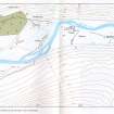
NGR NO 0273 8920
NGR Description Centred NO 027 892
Datum OSGB36 - NGR
Permalink http://canmore.org.uk/site/27753


- Council Aberdeenshire
- Parish Crathie And Braemar
- Former Region Grampian
- Former District Kincardine And Deeside
- Former County Aberdeenshire
NO08NW 7.00 centred 027 892
N08NW 7.01 centred NO 025 886 Farmstead (possible); Huts
See also NO08NW 1, NO08NW 3, NO08NW 4, NO08NW 9.
Scheduled with NO08NW 1, NO08NW 3, NO08NW 4, NO08NW 9 as 'Mar, townships, field systems, stills and kilns, Dubrach to E[ast] Dalvorar'.
Information from Historic Scotland, scheduling document dated 30 March 2009.
Observation (1987)
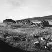
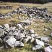
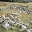
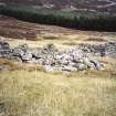
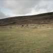
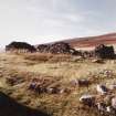
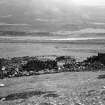
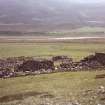
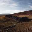
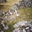
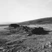
Settlement on fan apex to west of plantation with extensive rig and furrow below. Linear stone clearance heaps 30m by 2m by 1.5m high. A longhouse, 25m by 4m, partitioned into two, abutting a 20m-square enclosure with a rectangular structure, 12m by 6m, at back. Rectangular house, 10m by 5m, with a 4.5m diameter kiln at west end set into a knoll. Longhouse, 15m by 5m, standing to seven courses, another 15m by 6m, each with extended stone platform in front, and their back foundations scarped into the fan. Stone clearance heaps partly overlain by natural fan debris stone spreads. L-shaped longhouse, 10m by 10m by 5m, with another partitioned longhouse 18m by 6m. Square enclosure 20m by 18m with 15m by 5m structure tacked on outside. An 18m by 5m longhouse set on outside of head-dyke.
J S Smith 1987
Observation (1987)
Settlement with both linear and round clearance heaps. A longhouse 12m by 4m partially overlain by stone clearance heaps. A series of small enclosed plots and structures again partially overlain by clearance material. Longhouse 8m by 4m. A massively-built stone wall enclosure also containing some stone clearance material.
J S Smith 1987
Field Visit (20 July 1993)
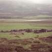
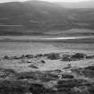
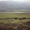
This township is situated on the outwash fan of the Allt Ton na Gaoithe towards the rear of the valley floor on the N side of the River Dee. Nine buildings (MAR93 285, 287-4) and a kiln (MAR93 286) form a fairly tight cluster with a hut (MAR93 295) to the S. A building and enclosure depicted on the current OS 1:10,000 map to the SE of this cluster is no more than a fortuitous arrangement of natural boulders and clearance. Two further buildings and a hut some 600m to the SW may have formed part of the settlement and are described under NO08NW 7.01.
The buildings measure between 6.2m by 2.4m internally and 12.7m by 2.9m internally. Two of the buildings (MAR93 287-8) lie parallel to each other and are built to a higher standard than the others, and these may represent the latest phase of construction within the township. These two buildings have terraces along the front, squared corners and coursed masonry in contrast to the others which have irregular, rounded corners and are built of roughly coursed boulders. Among the potentially earlier buildings, four (MAR93 285, 291-3) display some evidence of phasing. Most of the buildings are levelled into the slope on the N side and, where visible, entrances are in the S side. Two enclosures lie within the township; one is partially formed by MAR93 285/289, while the other lies on the S side of MAR93 291, blocking the entrance and possibly post-dating the building.
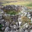
The kiln (MAR93 286) lies at the S edge of the cluster of buildings. The bowl measures 2.6m by 2.2m across the top, and is 1.8m deep, with a barn measuring 4.6m by 2.7m internally on the ENE. The flue, which is on the ENE, opens into the barn between two platforms built against the angle of the bowl and the side walls of the barn. The bowl may have been excavated into the slope and while it is stone-lined internally the exterior is embanked with turf.
A ruinous drystone wall runs NNW from the River Dee (to the SSW of the township) for some 560m before turning ENE and running past the NNW side of the township towards Tomnamoine (NO08NW 4). While this may have formed a head dyke to the township, it is likely to be a relatively late feature and may form part of a much larger enclosure taking in the townships of Dubrach (NO08NW 9) and Dalvorar (NO08NW 1), perhaps related to the establishment of a sheep-farm at Dalvorar after the clearance of Glen Dee (Watson and Allan 1990).
To the S and E of the buildings a predominantly grassy unenclosed area about 650m from E to W by about 150m across has been cultivated. The area immediately S of the buildings has been improved and may have had underground drains inserted, presumably relatively recently. To the E of this two types of rig are visible, both relatively straight, and aligned from NW to SE and ENE to WSW. The narrower rig (centred on NO 0285 8918) measures between 2m and 4m between furrows and may represent division, and improvement, of ridges measuring about 8m across (centred on NO 029 891). Resetting of ridges and cross-ploughing can be seen at NO 0307 8909. At the E end of the cultivated ground (NO 032 891), to the SE of the track, the ground is rougher and although few furrows are visible on the ground, rickles of stone may mark the edges of the ridges. Within this cultivated area there are patches of uncleared rough ground, littered with boulders, which have been used as a repository for clearance.
Within the cultivated ground to the ESE of the buildings, and presumably post-dating the cultivation, there is a row of four pits (NO 0293 8919), each measuring no more than 1.5m across by 0.2m in depth and surrounded by a low upcast mound. Some 3m to the SSE of the pits, is a rectangular area of turf-stripping measuring about 8m from ENE to WSW by 4m across.
Roy's map (Roy 1747-55) shows four buildings within cultivated ground under the name of Tongui. A depiction on Roberston's 1822 map (Robertson 1822) may relate to the two potentially later buildings (MAR93 287-8) within the township.
Watson and Allan identify the adjacent haugh centred on NO 028 889 as Dail na Cachaileithe, which may have given its name to this settlement, since a farm appears in 18th century estate rentals next to Tonnagaoithe called Dellnacattleg (e.g. 1763 rental in Aberdeen University Library, MS 3175)
(MAR93 285-95)
Visited by RCAHMS (DCC) 20 July 1993
Note (22 March 1999)
Five unroofed buildings, one of which is a long building, one unroofed structure, two enclosures, one of which is subdivided, and the boundary dyke noted above by RCAHMS (DCC) are depicted on the 1st edition of the OS 6-inch map (Aberdeenshire 1869, sheet xcvii). Seven unroofed buildings, one unroofed structure, three enclosures and the boundary wall are shown on the current edition of the OS 1:10000 map (1971).
Information from RCAHMS (SAH) 22 March 1999
Observation (1999)
NO08NW 3; NO 027 893 A programme of restoration and conservation was undertaken at two post-medieval sites on the Mar Lodge Estate. The township of Craig Phadruig on the N side of the Dee (NO08NW 3) and the township of Tonnagaoithe a little way upstream (NO 027 893). The conservation works were to repair recent damage and consolidate the structures.
At Tonnagaoithe, in one structure patches of mortar were identified within the build; this was interpreted as an internal render. A pair of 19th-century spectacles was also recovered from within the wall.
Full report deposited with the NMRS and Aberdeen SMR.
Sponsor: National Trust for Scotland
S Bain 1999.

