
Pitcairngreen


Fort (Period Unassigned)
Site Name Pitcairngreen
Classification Fort (Period Unassigned)
Alternative Name(s) Pitcairnfield; Pitcairngreen House
Canmore ID 26722
Site Number NO02NE 14
NGR NO 0690 2614
Datum OSGB36 - NGR
Permalink http://canmore.org.uk/site/26722


- Council Perth And Kinross
- Parish Redgorton
- Former Region Tayside
- Former District Perth And Kinross
- Former County Perthshire
NO02NE 14 0690 2614
(NO 0690 2613) Earthwork (NR)
OS 6" map (1959)
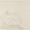
A semicircular earthwork at Pitcairngreen, on the edge of a steep wooded bank, 60ft high. The South side of the earthwork is formed by the straight unfortified edge of the bank 270ft long. To the north the semi-circular defences have been largely destroyed. To the West, where best preserved, they consist of a scarp 6ft high, with two mounds 5 and 3ft high beyond, on a steep slope; in the centre, towards the North, is a terrace 10ft wide in the rear of the outer mound.
The inner scarp is parapetted only at the entrance, which is from the NW. There is a rectangular foundation within the enclosure.
D Christison 1900.
This fort is situated at a height of 130ft OD on the crest of a descent of some 40ft which forms the N border of a promontory surrounded on the other sides by the River Almond. It stands at the edge of a cultivated field at a distance of 230 yards E of Pitcairnfield House. Much of the fort has been destroyed by ploughing and it has been further disfigured by the planting of trees within it and by the construction of two large water tanks in the SW sector. A pathway running along the brink of the descent has caused further mutilation, while what appears to be the termination of a substantial field boundary runs into the SE part.
The fort probably consisted of a D-shaped enclosure measuring about 190ft from E to W by about 120ft transversely. This is now surrounded by a ditch with no rampart on the inner lip, and it is possible that such a rampart did once exist but has been removed. The ditch measures up to 5ft in depth and 20ft in width. The whole of the NE section now stands alone, but the W part has a substantial stony bank along its outer lip. It is probable that this originally continued round to the NE, but that it has been obliterated in this sector. A second rampart lies outside the arc of the first, but after a stretch of only 40ft it too has been destroyed. The N arc of the ditch is breached by a stone-built causeway which appears to be of comparatively recent construction. The entrance was probably in the E, between the present termination of the ditch and the brink of the descent to the S. In addition to the tanks and the trees, the interior contains a sub-rectangular enclosure formed by a ruinous dyke, but is otherwise featureless.
Information from RCAHMS Marginal Land Survey, visited 21 February 1958
This earthwork is generally as described by Christison. There are only slight traces of parapetting of the inner scarp. The rectangular foundation within the earthwork appears to be fairly modern.
Re-surveyed at 1:2500.
Visited by OS (JTT) 26 October 1965.
Field Visit (21 February 1958)
Fort, Pitcairnfield
This fort is situated at a height or 130 feet OD on the crest of a descent of some 40 feet which forms the N border or a promontory surrounded on the other sides by the River Almond. It stands at the edge of a cultivated field at a distance of 230 yards E of Pitcairnfield House. Much of the fort has been destroyed by ploughing and it has been further disfigured by the planting of trees within it and by the construction of large water tanks in the SW sector. A pathway running along the brink of the descent has caused further mutilation, while what appears to be the termination of a substantial field boundary runs into the SE part. The fort probably consisted of a D-shaped enclosure measuring about 190 feet from E to W by about 120 feet transversely. This is now surrounded by a ditch with no rampart on the inner lip, and it is possible that such a rampart did once exist but has been removed. The ditch measures up to 5 feet in depth and 20 feet in width. The whole of the NE section now stands alone, but the W part has a substantial stony bank along its outer lip. It is probable that this originally continued round to the NE, but that it has been obliterated in this sector. A second rampart lies outside the arc or the first, but after a stretch of only 40 feet it too has been destroyed. The N arc of the ditch is breached by a stone-built causeway which appears to be of comparatively recent construction. The entrance was probably in the E, between the present termination of the ditch and the brink of the descent to the S. In addition to the tanks and the trees, the interior contains a sub-rectangular enclosure formed by a ruinous drystone dyke, but is otherwise featureless.
NO 069 261
Visited by RCAHMS 21 February 1958
Watching Brief (October 2007 - March 2008)
A Cultural Heritage Assessment was undertaken by CFA Archaeology to identify the potential impact of the proposed Almond Valley Village Materplan development. The assessment included a desk-based study and field reconnaissance survey. The assessment considered the likely effects on cultural heritage interests arising from the development of the proposed new village near Almondbank
CFA Archaeology (G. Mudie, S. Hickman) 2008
OASIS ID - cfaarcha1-267801
Note (4 May 2015 - 31 May 2016)
The remains of a D-shaped fort back onto the escarpment above the haughland of the River Almond E of Pitcairnfield House. It measures some 58m from E to W along the chord formed by the escarpment by 37m transversely (0.16ha) within a ditch 6m in breadth by 1.5m in depth. Little trace of a rampart survives on the inner lip of the ditch, but a thick external rampart is visible around the W quarter, and on the WSW a short length of a concentric outer ditch with a counterscarp bank can be seen adjacent to the escarpment. The only features visible within the interior are two water tanks and a rectangular drystone enclosure in the W half, and what is probably an old field-bank extending along the lip of the escarpment on the S. The entrance was probably on the E, though a more recent causeway has been built across the inner ditch on the NNW.
Information from An Atlas of Hillforts of Great Britain and Ireland – 31 May 2016. Atlas of Hillforts SC3012

