
Castle Menzies


Cropmark(S) (Period Unknown), Linear Feature(S) (Period Unassigned), Pit(S) (Period Unassigned)
Site Name Castle Menzies
Classification Cropmark(S) (Period Unknown), Linear Feature(S) (Period Unassigned), Pit(S) (Period Unassigned)
Canmore ID 25657
Site Number NN84NW 45
NGR NN 8370 4950
Datum OSGB36 - NGR
Permalink http://canmore.org.uk/site/25657
Ordnance Survey licence number AC0000807262. All rights reserved.
Canmore Disclaimer.
© Copyright and database right 2024.
- Correction
- Favourite

SC 1690320
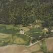
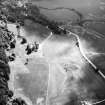
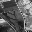
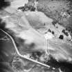
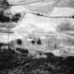
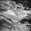
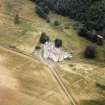
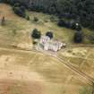
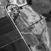
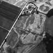
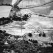
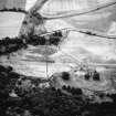
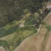
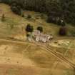
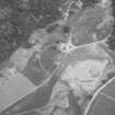
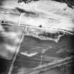
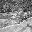
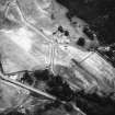
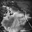
Oblique aerial view of Castle Menzies centred on a tower house, well, walled garden and military road, and the crop marks of pits, a garden and linear cropmarks, taken from the S.
RCAHMS Aerial Photography
3/6/1998
© Crown Copyright: HES

SC 1702292
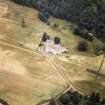
Castle Menzies. Aerial view.
RCAHMS Aerial Photography
1986
© Crown Copyright: HES

SC 1702300
Castle Menzies. Aerial view from North West.
RCAHMS Aerial Photography
1986
© Crown Copyright: HES

SC 1702305
Castle Menzies. Aerial view from South.
RCAHMS Aerial Photography
1986
© Crown Copyright: HES

SC 1702331
Castle Menzies. Aerial view from South West.
RCAHMS Aerial Photography
1988
© Crown Copyright: HES

SC 1702332
Castle Menzies. Aerial view from South.
RCAHMS Aerial Photography
1988
© Crown Copyright: HES


SC 1702409
Castle Menzies. Aerial view from North West.
RCAHMS Aerial Photography
1978
© Crown Copyright: HES

SC 1782656
Castle Menzies. Aerial view from East.
RCAHMS Aerial Photography
1986
© Crown Copyright: HES

SC 1782660
Castle Menzies. Aerial view from North West.
RCAHMS Aerial Photography
1986
© Crown Copyright: HES

SC 1782665
Castle Menzies. Aerial view from South.
RCAHMS Aerial Photography
1986
© Crown Copyright: HES

SC 1782711
Castle Menzies. Aerial view from South West.
RCAHMS Aerial Photography
1988
© Crown Copyright: HES

SC 1782713
Castle Menzies. Aerial view from East.
RCAHMS Aerial Photography
1988
© Crown Copyright: HES

SC 672596
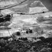
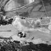
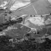
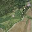
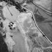
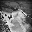
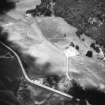
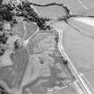
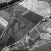
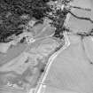
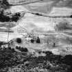
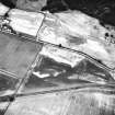
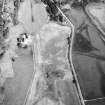
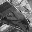
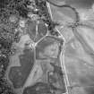
Aerial view of Castle Menzies showing the cropmarks of its former garden.
RCAHMS Aerial Photography
1986
© Crown Copyright: HES

SC 1112644
Oblique aerial view of Castle Menzies centred on a tower house, well, walled garden and military road, and the crop marks of pits, a garden and linear cropmarks, taken from the SSW.
RCAHMS Aerial Photography
3/6/1998
© Crown Copyright: HES

SC 1702288
Castle Menzies. Aerial view.
RCAHMS Aerial Photography
1986
© Crown Copyright: HES

SC 1702302
Castle Menzies. Aerial view from West.
RCAHMS Aerial Photography
1986
© Crown Copyright: HES

SC 1702306
Castle Menzies. Aerial view from East.
RCAHMS Aerial Photography
1986
© Crown Copyright: HES


SC 1702385
Oblique aerial view of Castle Menzies centred on a tower house, well, walled garden and military road, and the crop marks of pits, a garden and linear cropmarks, taken from the SSE.
RCAHMS Aerial Photography
3/6/1998
© Crown Copyright: HES

SC 1782666
Castle Menzies. Aerial view from East.
RCAHMS Aerial Photography
1986
© Crown Copyright: HES

SC 1782710
Castle Menzies. Aerial view from West.
RCAHMS Aerial Photography
1988
© Crown Copyright: HES

SC 2391024
Castle Menzies, NN84NW 45, Ordnance Survey index card, page number 2, Recto
Records of the Ordnance Survey, Southampton, Hampshire, England
1958
© Crown Copyright: HES (Ordnance Survey Archaeology Division Collection)

SC 672586
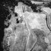
Scanned image of aerial view of Castle Menzies.
RCAHMS Aerial Photography
1978
© Crown Copyright: HES

SC 1702285
Castle Menzies. Aerial view from East.
RCAHMS Aerial Photography
1986
© Crown Copyright: HES

SC 1702286
Castle Menzies. Aerial view.
RCAHMS Aerial Photography
1986
© Crown Copyright: HES

SC 1702333
Castle Menzies. Aerial view from East.
RCAHMS Aerial Photography
1988
© Crown Copyright: HES


SC 1702386
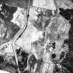
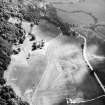
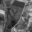
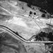
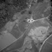
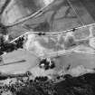
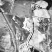
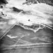
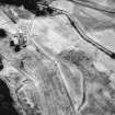
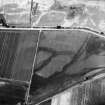
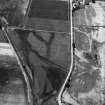
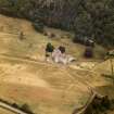
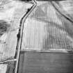
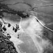
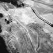
Oblique aerial view centred on the cropmarks of pits and linear cropmarks, with tower house, pits and walled garden adjacent, taken from the WSW.
RCAHMS Aerial Photography
6/7/1998
© Crown Copyright: HES

SC 1702291
Castle Menzies. Aerial view.
RCAHMS Aerial Photography
1986
© Crown Copyright: HES

SC 1702303
Castle Menzies. Aerial view from West.
RCAHMS Aerial Photography
1986
© Crown Copyright: HES


SC 1702329
Castle Menzies. Aerial view from West
RCAHMS Aerial Photography
1988
© Crown Copyright: HES


SC 1782661
Castle Menzies. Aerial view from West.
RCAHMS Aerial Photography
1986
© Crown Copyright: HES

SC 1782664
Castle Menzies. Aerial view from South West.
RCAHMS Aerial Photography
1986
© Crown Copyright: HES

SC 2391027
Castle Menzies, NN84NW 45, Ordnance Survey index card, Recto
Records of the Ordnance Survey, Southampton, Hampshire, England
1958
© Crown Copyright: HES (Ordnance Survey Archaeology Division Collection)

SC 2391032
Castle Menzies, NN84NW 45, Ordnance Survey index card, page number 1, Recto
Records of the Ordnance Survey, Southampton, Hampshire, England
1958
© Crown Copyright: HES (Ordnance Survey Archaeology Division Collection)

SC 1702301
Castle Menzies. Aerial view from West.
RCAHMS Aerial Photography
1986
© Crown Copyright: HES


SC 1702384
Oblique aerial view of Castle Menzies centred on a tower house, well, walled garden and military road, and the crop marks of pits, a garden and linear cropmarks, taken from the SW.
RCAHMS Aerial Photography
3/6/1998
© Crown Copyright: HES

DP 281505
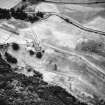
Oblique aerial view.
Historic Environment Scotland
19/7/2018
© Historic Environment Scotland

SC 1782658
Castle Menzies. Aerial view.
RCAHMS Aerial Photography
1986
© Crown Copyright: HES

SC 1782667
Castle Menzies. Aerial view from East.
RCAHMS Aerial Photography
1986
© Crown Copyright: HES

SC 2391037
Castle Menzies, NN84NW 45, Ordnance Survey index card, page number 3, Recto
Records of the Ordnance Survey, Southampton, Hampshire, England
1958
© Crown Copyright: HES (Ordnance Survey Archaeology Division Collection)

SC 1689602
Oblique aerial view of Castle Menzies centred on a tower house, well, walled garden and military road, and the crop marks of pits, a garden and linear cropmarks, taken from the SSW.
RCAHMS Aerial Photography
3/6/1998
© Crown Copyright: HES


SC 1702387
Oblique aerial view centred on the cropmarks of pits and linear cropmarks, with tower house, pits and walled garden adjacent, taken from the SW.
RCAHMS Aerial Photography
6/7/1998
© Crown Copyright: HES

SC 1782657
Castle Menzies. Aerial view.
RCAHMS Aerial Photography
1986
© Crown Copyright: HES

SC 1782659
Castle Menzies. Aerial view.
RCAHMS Aerial Photography
1986
© Crown Copyright: HES

SC 1782662
Castle Menzies. Aerial view from West.
RCAHMS Aerial Photography
1986
© Crown Copyright: HES

SC 2391029
Castle Menzies, NN84NW 45, Ordnance Survey index card, page number 1, Recto
Records of the Ordnance Survey, Southampton, Hampshire, England
1958
© Crown Copyright: HES (Ordnance Survey Archaeology Division Collection)

SC 1689807
Castle Menzies. Aerial view.
RCAHMS Aerial Photography
1978
© Crown Copyright: HES

SC 1702289
Castle Menzies. Aerial view.
RCAHMS Aerial Photography
1986
© Crown Copyright: HES

SC 1702290
Castle Menzies. Aerial view.
RCAHMS Aerial Photography
1986
© Crown Copyright: HES


SC 1702330
Castle Menzies. Aerial view from West.
RCAHMS Aerial Photography
1988
© Crown Copyright: HES


SC 1782709
Castle Menzies. Aerial view from West
RCAHMS Aerial Photography
1988
© Crown Copyright: HES

SC 1875901
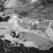
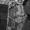
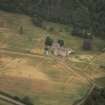
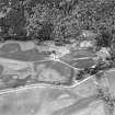
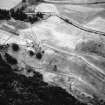
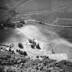
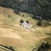
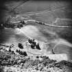
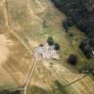
Aerial view of Castle Menzies showing tower house, well, walled garden and military road, Perthshire
RCAHMS Aerial Photography
3/6/1998
© Crown Copyright: HES

SC 2391023
Castle Menzies, NN84NW 45, Ordnance Survey index card, Recto
Records of the Ordnance Survey, Southampton, Hampshire, England
1958
© Crown Copyright: HES (Ordnance Survey Archaeology Division Collection)

SC 2391035
Castle Menzies, NN84NW 45, Ordnance Survey index card, page number 2, Recto
Records of the Ordnance Survey, Southampton, Hampshire, England
1958
© Crown Copyright: HES (Ordnance Survey Archaeology Division Collection)

SC 1702287
Castle Menzies. Aerial view.
RCAHMS Aerial Photography
1986
© Crown Copyright: HES

SC 1702304
Castle Menzies. Aerial view from South West.
RCAHMS Aerial Photography
1986
© Crown Copyright: HES

SC 1702307
Castle Menzies. Aerial view from East.
RCAHMS Aerial Photography
1986
© Crown Copyright: HES


SC 1702383
Oblique aerial view of Castle Menzies centred on a tower house, well, walled garden and military road, and the crop marks of pits, a garden and linear cropmarks, taken from the WSW.
RCAHMS Aerial Photography
3/6/1998
© Crown Copyright: HES

SC 1782663
Castle Menzies. Aerial view from West.
RCAHMS Aerial Photography
1986
© Crown Copyright: HES

SC 1782712
Castle Menzies. Aerial view from South.
RCAHMS Aerial Photography
1988
© Crown Copyright: HES

SC 2391031
Castle Menzies, NN84NW 45, Ordnance Survey index card, page number 2, Recto
Records of the Ordnance Survey, Southampton, Hampshire, England
1958
© Crown Copyright: HES (Ordnance Survey Archaeology Division Collection)


- Council Perth And Kinross
- Parish Weem
- Former Region Tayside
- Former District Perth And Kinross
- Former County Perthshire

