
Creag A' Ghiubhais, Balnacraig


Fort (Period Unassigned)
Site Name Creag A' Ghiubhais, Balnacraig
Classification Fort (Period Unassigned)
Canmore ID 24889
Site Number NN74NE 10
NGR NN 7512 4776
Datum OSGB36 - NGR
Permalink http://canmore.org.uk/site/24889


- Council Perth And Kinross
- Parish Fortingall
- Former Region Tayside
- Former District Perth And Kinross
- Former County Perthshire
NN74NE 10 7512 4776.
(NN 750 477) Fort
Information from M E C Stewart, 14 December 1964.
Bivallate hill-fort visible on RAF APs (106G/Scot/UK65: 3414-15, flown 1946).
(Undated) information in NMRS.
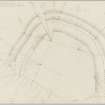
This fort, at NN 7512 4776, occupies a commanding position on a spur with a sheer cliff forming the SW side.
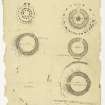
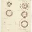
It consists of three concentric curving ramparts now reduced to grassy terraces, which are partially obscured by dense rhododendrons. The outer one has been recently ploughed through by the Forestry Commission, exposing its content of earth and stone. The entrance is not evident. A ruinous ornamental path cuts through the three ramparts in the NW. Surveyed at 1:10,000.
Visited by OS (JM) 10 April 1975
No change to previous field report.
Surveyed at 1:2500.
Visited by OS (BS) 28 November 1978
Field Visit (9 October 1957)
Fort, Craig a’Ghuibhais, Balnacraig
This fort is situated at a distance of 560 yards NNE Balnacraig farmhouse on the crest of the steep slope which here forms the N side of the valley of the River Lyon. It stands at an elevation of 840 feet OD and at 500 feet above the river. The approaches to the fort from N to W lie over gently rising ground, while that from the SW is but a little steeper. To the SE and E however the ground falls away first in a precipitous rocky cliff which develops lower down into a less abrupt but still steep slope. The fort is D-shaped on plan, measuring 240 feet along the chord, which is the crest of the cliff, by 190 feet transversely. It is formed by three concentric ramparts, very denuded and represented only by low scarps. The entrance is in the E. Almost the whole of the fort has been planted with conifers, and at the date of visit, though these had been felled the interior was choked with rhodendrons and no internal features were visible.
NN 750 477
Visited by RCAHMS 1957
Reference (1963)
This site is noted in the ‘List of monuments discovered during the survey of marginal land (1956-8)’, published in Vol. 1 of the RCAHMS Inventory of Stirlingshire. The 26 monuments were listed by their name, classification, parish and county, and the list also includes an indication of whether they had been planned (P), whether they were visible only as a cropmark (C), and whether they were worthy of preservation (*).
Information from RCAHMS (GFG) 30 October 2012.
Note (8 December 2014 - 18 May 2016)
This fort is situated on the edge of the precipitous descent down into Glen Lyon above Balnacraig. D shaped on plan, with its chord formed by the natural escarpment on the E and SE, the interior of the fort measures about 73m from NE to SW by 58m transversely (0.33ha). The defences comprise an arc of three concentric ramparts, each reduced to little more than a scarp, but forming a belt 22m deep. In 1957 RCAHMS investigators identified a gap through all three ramparts on the W as the probable entrance. The interior, which has been planted with trees is featureless, and when the OS visited in 1975 forestry ploughing had overridden the outermost rampart.
Information from An Atlas of Hillforts of Great Britain and Ireland – 18 May 2016. Atlas of Hillforts SC2626

