
Glasvaar 5


Cup Marked Rock (Prehistoric)
Site Name Glasvaar 5
Classification Cup Marked Rock (Prehistoric)
Canmore ID 22819
Site Number NM80SE 58
NGR NM 88406 01445
Datum OSGB36 - NGR
Permalink http://canmore.org.uk/site/22819


- Council Argyll And Bute
- Parish Kilmichael Glassary
- Former Region Strathclyde
- Former District Argyll And Bute
- Former County Argyll
Field Visit (May 1984)
NM80SE 58 8841 0143
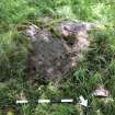
Immediately S of NM80SE 50, there is a rock-sheet to the S of a field wall; on it there are two weathered plain cupmarks and two small depressions.
RCAHMS 1988, visited May 1984.
Note (8 January 2018)
Date Fieldwork Started: 08/01/2018
Compiled by: Parallel Grooves
Location Notes: Glasvaar 5 is located within rough grazing, right-to-roam land which slopes gently to the W. There are views of Stroneskar Farm and Beinn a' Chlachain Dubh to the W. The panel forms part of a rocky outcrop approximately 20 m E uphill from the track running N-S to Glasvaar farmhouse. It is immediately S of a stone field wall which runs E-W, abutting the SW extent of the garden wall surrounding Glasvaar farmhouse. Glasvaar 4 is located immediately to the N of Glasvaar 5, within the stone field wall. A large deciduous tree is located to the N of both panels; its branches extend over both. A burial cairn is situated in the same field approximately 50 m to the N.
Panel Notes: Glasvaar 5 comprises a roughly rectangular outcrop measuring 2.0 m by 1.6 m and a maximum height of 0.4 m. The surrounding rock surfaces are partially covered by turf, and no other motifs are visible. The carved surface is inclined 9 degrees to the N and is largely flat, with natural features including cracks, fissures and several irregular circular depressions/hollows which may be mistaken for cupmarks. Three single cupmarks and one potential cupmark are visible. Rock type identified using online information from the British Geological Survey.

