
Inverliever, Loch Awe


Crannog (Period Unassigned)
Site Name Inverliever, Loch Awe
Classification Crannog (Period Unassigned)
Canmore ID 22774
Site Number NM80SE 17
NGR NM 8894 0484
Datum OSGB36 - NGR
Permalink http://canmore.org.uk/site/22774


- Council Argyll And Bute
- Parish Kilmartin
- Former Region Strathclyde
- Former District Argyll And Bute
- Former County Argyll
NM80SE 17 8894 0484
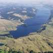
(NM 8894 0485) Crannog (NR).
OS 1:10,000 map, (1975)
Investigation in 1972 by a naval sub-aqua team under the direction of Dr T D McArdle of Edinburgh University confirmed that the island in Loch Awe, situated in a small bay to the west of Liever Island and about 520 metres NW of the headland Rubha Mhic Chaisein, is a crannog. It is provided with a causeway, though this is possibly of modern construction.
F O Blundell 1913; T D McArdle and C M McArdle 1972.
Surveyed at 1:10 000 scale.
Visited by OS (W D J), 3 March 1970.
Field Visit (April 1985)
In the course of an underwater survey of Loch Awe in 1972 by members of the Naval Air Command Sub-Aqua Club some sixty possible sites were examined and twenty crannogs were confirmed; (Hardy, McArdle and Miles 1973); of these, sixteen are situated in that part of Loch Awe that falls within the Lorn area of Argyll (RCAHMS 1975), but four at the southern end of the loch are in Mid Argyll. The tops of NM80SE 17 and NM80SE 18 are usually visible above water-level, and the stony causeway of NM80SE 17 may still be seen from the shore.
(1) NM 889048 (NM80SE 17). Situated in the bay between Liever Island and Rubha Mhic Chaisein and 60m from the shore, there is a crannog which measures about 20m by 18m, with a curving stony spit on the N, probably the protecting arm of a boat-landing. (Blundell 1913; Campbell and Sandeman 1964)
RCAHMS 1988, visited April 1985.

