
Dun Mhuilig


Galleried Dun (Prehistoric)
Site Name Dun Mhuilig
Classification Galleried Dun (Prehistoric)
Canmore ID 22565
Site Number NM70SE 14
NGR NM 7770 0187
Datum OSGB36 - NGR
Permalink http://canmore.org.uk/site/22565


- Council Argyll And Bute
- Parish Craignish
- Former Region Strathclyde
- Former District Argyll And Bute
- Former County Argyll
NM70SE 14 7770 0187.
(NM 7770 0188) Dun Mhuilig (NR) (Fort) (NR)
OS 6" map, Argyllshire, 2nd ed., (1900)
Dun Mhuilig: All that remains of this galleried dun are the lower courses of a massive wall drawn across the neck of a high rocky bluff. It widens from 12'-15' and contains a mural gallery with three slab lintels still in situ. At its E end, the wall stops on the lip of a precipice; the W end curves and the inner wall face thickens at this point, perhaps towards the entrance, of which there is now no trace. To the SW, the wall seems to have incorporated an outcrop ridge, on the outside of which some facing stones are still in situ. The steepness of the slope may have been considered sufficient protection on the S and E, but it is just possible that the circuit was once complete, and this part of it has been removed by landslips. At present, the area enclosed is U-shaped, measuring 50' N-S by 30'. The site is further defended on the landward side by two ruined walls drawn across the neck, c. 42' and 77' respectively from the dun.
A Graham 1950; A Young 1964.
All that survives of this galleried dun is the N wall, standing 1.5m high across the neck of the promontory and slight traces of the wall 3.0m-3.5m wide on the W and S. On the E, the bottom course of an outer wall face can also be traced. Within the N wall is a mural gallery c. 0.7m wide. A probable entrance is indicated in the W wall where the bottom course of the N side is visible. About 10.0m N of the dun, a rock-cut ditch has been drawn across the promontory. The two ruined walls on the land-ward (E) side mentioned above are the retaining walls of an ornamental path.
Name confirmed.
Revised at 1/2500.
Visited by OS (RD) 13 October 1971.
Field Visit (May 1983)
The imposing remains of a galleried dun occupy the summit of a hill 600m ENE of Craignish Castle (NM70SE 1); (Campbell and Sandeman 1964), to the N and W there are lower terraces, but on the S and E the ground falls over steep slopes and rock outcrops. A revetted path has been constructed up the E side, probably during the later 19th century.
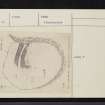
Originally the dun may have measured about 12m by 9m internally, but although its wall is exceptionally well preserved on the N, and relatively so on the W, to the S and E it has been reduced to a mere scarp. It is probable that on these sides it was removed to provide material for the elaborate access path for, where the ground has fallen away at a point on the SE, a mass of tumbled stone is visible below. The wall on the W side has been reduced to a bank of stony rubble, in which several inner and outer facing-stones can still be seen, indicating a thickness near the mid-point of about 3.5m. On the N, however, it stands 1.4m above the surrounding debris, its outer face displaying a conspicuous batter; at the lowest point where measurement is possible, it is between 4m and 4.5m thick. At the E end of the N side the wall terminates in a straight face, which is pierced by the entrance to an intramural gallery. Varying in width between 1.0m and 0.35m, the gallery can be traced for a distance of about 10m, and its walls stand 1.4m in maximum height; the present floor is a mass of rubble that rises from E to W, possibly concealing a flight of steps. Two lintels survive in position a little to the W of the point at which an entrance, 0.6m wide, gave access to the gallery from the interior of the dun. About 2.5m to the W of this opening and 0.3m above the level of the interior, the inner face of the dun wall is set back about 0.3m to form a scarcement-like ledge; in its western extension this is replaced by a rising series of individual stones that project from the wall-face. The precise purpose which this feature served cannot be readily ascertained, but it may be related to the observed variation in wall-fabric - the massive nature of the upper courses contrasting markedly with the relatively small neat masonry of the lower.
The entrance to the dun may have been on the W (a on RCAHMS plan, RCAHMS 1988), the line facing at right angles to the inner face at that point being part of the N passage-wall. Although the outer face appears to continue unbroken across the mouth of such an entrance, it is possible that this may represent deliberate blocking in a secondary phase. Conceivably the straight face at the E end of the N face could have formed the W side of a postern; however, the similarly abrupt angle at the S end of the W side may also indicate that, as at Castle Dounie (NR79SE 13; RCAHMS 1988), the dun wall was constructed in separate sectors, those on the S and E being of slighter character than elsewhere on the perimeter.
The interior is much overgrown, and several large holes have been dug in it. A wall of no great age encloses terraces to the N and W, and another runs from below the dun wall down the hillside, but there is no evidence of any outwork associated with the dun.
Visited May 1983
RCAHMS 1988.
Publication Account (2007)
NM70 1 DUN MHUILIG
NM/7770 0188
This L-shaped promontory semi-broch in Craignish – classed as a galleried dun by the Commission [4] – is the southernmost known example of this class of ‘half-brochs’ (visited in 1964 and June 2007). It stands on the summit of a steep-sided promontory on the west shores of Loch Craignish. There are no signs of any ancient walling along the east and south sides of the enclosed area, where the slope is very steep. The approximately rect-angular enclosed area measures about 10m by 13m.
The north-facing part of the main wall is the best preserved and runs slightly north of west for about 9m (30 ft) from the east slope where it turns south through a sharp angle towards the edge of the promontory for 18.3m (60 ft). This side is badly ruined and it may be that the stone was taken to build the elaborate access path which runs up along the eastern slope [4]. The Commission’s surveyors found the remains of built faces at the two ends. This north wall is about 3.6m (12 ft) wide until the corner and it contains an upper gallery with three lintels still in position; this gallery emerges in the built end, a unique feature. On the inside face of the corner a scarcement appears above the debris and this is about 1.2m (4 ft) below these lintels. It is not clear from the published accounts whether the gallery rests on a solid base or on another one at ground-level; probably debris inside the gallery obscures its floor.
In the broken-down west wall can be seen the north side of a doorway leading into the wall from the enclosed area. Assuming the site to be a semibroch this doorway must surely have led to the mural stair which would have risen to the right, towards the corner of the structure. The entrance passage must also be in this part of the wall but is not visible – unless the doorway mentioned is also its inner end.
Two probably recent curved stone walls bar off the north and west sides of the end of the ridge and enclose the Iron Age building. Whether this indicates a reuse of the building in historical times only systematic exploration will discover.
Sources: 1. NMRS site no. NM 70 SE 14: 2. Graham 1948 , 52-55 and fig. 2: 3. Young 1962, 194: 4. RCAHMS 1988, 188-89, no. 310 and fig.
E W MacKie 2007

