
Camas Nan Geall


Chambered Cairn (Neolithic)
Site Name Camas Nan Geall
Classification Chambered Cairn (Neolithic)
Canmore ID 22349
Site Number NM56SE 1
NGR NM 5608 6194
Datum OSGB36 - NGR
Permalink http://canmore.org.uk/site/22349


- Council Highland
- Parish Ardnamurchan
- Former Region Highland
- Former District Lochaber
- Former County Argyll
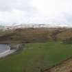
Camas nan Geall (bay of strangers) Ardnamurchan's long history of settlement can be traced through the rich layers of material evidence scattered about this unexpectedly fertile crescent in the lee of volcanic Ben Hiant (Beinn Shianta - holy mountain). Vestigial chambered cairn, parts of chamber evident but most cairn stones looted for later buildings. To the south, two graveyards, most notable the burial ground of the Campbells of Ardslignish, 18th century, with limemortared rubble masonry enclosing, among other fragments, two fine ogee-pedimented headstones carved with cherubs' heads. One stone depicts the Crucifixion in high relief, the other, dated 1737, a Campbell coat of arms flanked by reeded pilasters. Standing stone to south-west, one face carved with Early Christian motifs: a dog between two crosses. To the south (near Ardslignish farmhouse), old burying ground, now little more than a turf-walled enclosure. On the western headland, fragments of an Iron Age promontory fort. Around the bay, the evolution of the local dwelling types that superseded creel houses is well represented. Structures surviving in ruin include the round-angled, chimneyless stone house which had cruck couples and thatch, and the post-clearance 'improved' shepherd's cottage, with gables and slated roof. Sheep fanks built of stones from abandoned dwellings symbolise 19th century changes in land use and settlement.
Taken from "Western Seaboard: An Illustrated Architectural Guide", by Mary Miers, 2008. Published by the Rutland Press http://www.rias.org.uk

NM56SE 1 5608 6194.
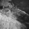
(NM 5608 6194) Chambered Cairn (NR) (remains of)
OS 1:10,000 map, (1974)
The remains of this Clyde-type chambered cairn were in a condition generally similar to that described above (RCAHMS) when seen in 1970.
Surveyed at 1:2500.
Visited by OS (N K B) 8 June 1970
A largely destroyed chambered cairn is sited here. These monuments are generally considered to belong to the neolithic period and to date approximately between 3000 and 2000 BC. They are usually taken to indicate the prescence of farming communities in contrast to the nomadic settlements of the mesolithic period. This site is excluded from the SSSI. This has been a desk assessment area.
J Wordsworth, Scottish Natural Heritage, 1993
Field Visit (May 1972)
NM 560 619
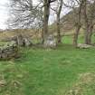
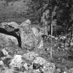
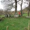
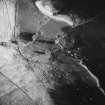
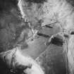
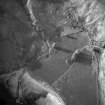
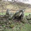
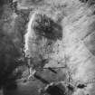
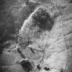
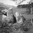
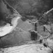
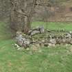
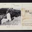
Chambered Cairn, Camas nan Geall (ARG 2): This cairn stands at the head of the bay known as Camas nan Geall, within a level arable field bounded by the sea to the SW and the lower slopes of Ben Hiant and Beinn Bhuidhe on the other three sides. Most of the cairn, which was aligned roughly NW and SE, has been destroyed to provide building material for a township, but parts of the chamber and facade still survive. In only two places does any cairn material remain, firstly at the NE horn of the facade, where it is up to 1m in height, and secondly between the SW side of the chamber and the adjacent township-building. The tip of the horn of the facade is marked by a stone (0.8m high and 1.1m by 0.3m at the base) set at right angles both to the end of the facade and to the outer edge of the cairn on the NE. The cairn material at the end of the horn has, however, been destroyed by a farm track. Two other stones of this half of the facade remain, one lying prone and the other measuring 2.1m in height, 1.75m in breadth and up to 0.5m in thickness at the base. Another fallen facade-stone lies between the S portal and the later building. If the stones of the facade had been symmetrically disposed, it seems likely that it was originally semicircular on plan, measuring about 18m across and 10m in depth.
The chamber is entered between a pair of impressive portal stones, the SW stone standing to a height of 1.5m; the two remaining side-slabs are 1m and 1.4m in height, but the capstone has slipped off and rests against the SW side-slab. At the present time the chamber measures 1.8m in length and about 1.2m in breadth, but there is no doubt that it originally extended further to the NW; several massive stones, which may have formed part of the chamber or the facade, have been used in the construction of the near-by buildings.
RCAHMS 1980, visited May 1972.
Photographic Survey (1976)
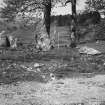
Archaeological Evaluation (22 April 2022 - 7 September 2022)
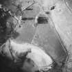
NM 56048 61893 A new season of fieldwork at Camas Nan Geall took place in April, August and September 2022 as part of the ERDF funded programme, The Real Wild West: Adopt-a-Monument on Ardnamurchan. The work was completed by members of staff from Archaeology Scotland working alongside volunteers from the Ardnamurchan Heritage and History Association (AHHA) and Rose Geophysical Consultants. The work comprised of a gradiometer survey of Camas Nan Geall, and a resistivity survey of the chambered cairn and burial ground located within the bay. Results of the gradiometer survey were used to inform the location of five targeted evaluation trenches to investigate the potential archaeological remains identified in the survey.
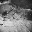
The evaluation trenches showed evidence of raised beach remains throughout the bay, with occasional artefacts recovered from the topsoil, including ceramics and glass used for middening, and a probable Neolithic arrowhead. Only one of the evaluation trenches, Trench 4, contained any archaeological features, which may represent a period, or periods, of prehistoric activity. These features include a discrete spread of ephemeral pits, a gully, and a possible curvilinear ditch cut into the natural bands of glacial gravels.
The ditch may represent the perimeter of an enclosure, or may have been associated with a structure and has potentially been modified later, with evidence of at least one posthole cutting through its fill. The ditch fill itself appears to have been deliberately deposited using nearby pebbles from either the burn or shoreline.
The discrete spread of small ephemeral pits and a linear feature were located to the S of the ditch and may represent random activity along the former shoreline, potentially temporary in nature, for shelters or disposal of materials.
This area of land has been used for agricultural purposes for several hundred years and ploughing activity appears to have disturbed or destroyed the upper levels of the archaeological features identified, with only the basal layers now remaining.
Archive: NRHE (intended)
Funder: Natural and Cultural Heritage Fund managed by NatureScot, supported by the European Regional Development Fund (which is part of the European Structural Fund Programmes) and Historic Environment Scotland
Ian Hill – Archaeology Scotland
(Source: DES Volume 23)

