
Following the launch of trove.scot in February 2025 we are now planning the retiral of some of our webservices. Canmore will be switched off on 24th June 2025. Information about the closure can be found on the HES website: Retiral of HES web services | Historic Environment Scotland
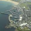
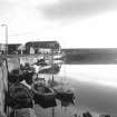
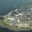
Fraserburgh Harbour


Harbour (16th Century)
Site Name Fraserburgh Harbour
Classification Harbour (16th Century)
Alternative Name(s) Fraserburgh Bay; North Sea
Canmore ID 21119
Site Number NK06NW 3
NGR NK 0013 6701
NGR Description Centred NK 0013 6701
Datum OSGB36 - NGR
Permalink http://canmore.org.uk/site/21119


- Council Aberdeenshire
- Parish Fraserburgh
- Former Region Grampian
- Former District Banff And Buchan
- Former County Aberdeenshire
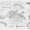
NK06NW 3.00 centred 0013 6701
Extends onto map sheet NJ96NE.
NK06NW 3.01 NK 0000 6738 Boatbuilding Yard
NK06NW 3.02 NK 00 67 Boatbuilding Yard
NK06NW 3.03 NK 00390 66891 Beacon (Balaclava Breakwater)
NK06NW 3.04 NK 0010 6697 Pillbox
NK06NW 3.05 NK 0021 6675 Pillbox
NK06NW 3.06 NK 00221 66920 Outer Harbour
NK06NW 3.07 NK 00047 67203 Balaclava Harbour (Extends onto map sheet NJ96NE)
NK06NW 3.08 NK 00111 66816 Faithlie Harbour (Extends onto map sheet NJ96NE)
NK06NW 3.09 NK 00018 67009 North Harbour (Extends onto map sheet NJ96NE)
NK06NW 3.10 NK 00003 66916 South Harbour (Extends onto map sheet NJ96NE)
NK06NW 3.11 NK 00392 66886 to NK 00368 66934 to NK c. 00135 67039 Balaclava Breakwater (North Pier)
NK06NW 3.12 NK 00329 66898 to NK c. 00352 66934 Balaclava Breakwater, The Spur
NK06NW 3.13 NK 00124 67086 Balaclava Pier, Steamboat Quay and Slipway
NK06NW 3.14 NK 00101 67127 Balaclava Pier, Abernethy Jetty
NK06NW 3.15 NK 00080 67272 Balaclava Pier, Bailie Dickson's Jetty
NK06NW 3.16 NK 00033 67330 Balaclava Harbour, Dry Dock
NK06NW 3.17 NK 00029 67259 to NJ c. 99937 67239 Provost Park's Jetty (Balaclava Harbour: Extends onto map sheet NJ96NE)
NK06NW 3.18 NK 00038 67123 to NJ c. 99927 67128 Provost Anderson's Jetty (Balaclava Harbour: Extends onto map sheet NJ96NE)
NK06NW 3.19 NK 00111 66947 to NJ c. 99998 67056 to NJ c. 99917 67058 North Pier (Extends onto map sheet NJ96NE)
NK06NW 3.20 NK 00177 66861 to NK c. 00230 66792 Burnett Pier
NK06NW 3.21 NK 00159 66859 to NK 00053 66940 to NK 00047 66871 West Pier
NK06NW 3.22 NK 00039 66941 to NJ c. 99966 66995 to NJ 99897 66968 Middle Jetty (Extends onto map sheet NJ96NE)
NK06NW 3.23 NK 00051 66928 Control Tower (West Pier)
NK06NW 3.24 NK 00044 66937 South Harbour, Storm Gates
NK06NW 3.25 NK 00169 66861 Faithlie Harbour, Storm Gates
NK06NW 3.26 NK 00033 66871 to NJ c. 99988 66850 South Pier (Extends onto map sheet NJ96NE)
NK06NW 3.27 NK 00039 66874 Drawbridge
NK06NW 3.28 NK 00094 66807 to NK c. 00017 66756 Faithlie Jetty
NK06NW 3.29 NK 00294 66847 to NK c. 00143 66702 South Breakwater
NK06NW 3.30 NK 00116 66684 South Harbour, Boat Lift
NK06NW 3.31 NK 00230 66779 Defence Obstruction
NK06NW 3.32 NK 00326 66948 Defence Obstruction
See also:
NJ96NE 7 NJ 99864 67528 Kinnaird Head Lighthouse
NJ96NE 34 NJ 99910 67250 Bisset's Quay, Ice Factory (Harbour Road)
NJ96NE 38 NJ 9994 6735 Balaclava Quay, J and G Forbes and Co, Boatbuilders
NJ96NE 88 NJ c. 9987 6699 Middle Jetty, Harbour Works Office
NJ96NE 248 NJ 99918 67100 Lifeboat Station (Spending Beach)
NK06NW 164 NK 00012 66669 Fish Market (Harbour Road)
NJ96NE 247 NJ 99972 66915 to NJ c. 99968 66850 Saltoun Jetty
NJ96NE 248 NJ 99939 66917 to NJ c. 99882 66906 Bruce's Jetty
NMRS NOTES
Fraserburgh Harbour.
ARCHITECT: Thomas Telford (1803-1821).
(Undated) information in NMRS.
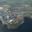
(Location cited as NK 000 670). A complex harbour, consisting of eight piers and a breakwater, forming a series of basins. The first pier was built in 1576, but construction of the modern harbour began in 1807. The present breakwater was built between 1855 and c. 1880.
J R Hume 1977.
(Located at NK 00 66). The origins of Fraserburgh harbour are closely associated with the name of Alexander Fraser of Philorth, who, if the chronology of our various sources is trustworthy, appears to have looked after the town's affairs throughout a remarkably, though in fact not impossibly, long career. Thus we are led to conclude that he founded the place as a burgh of barony about 1563, that is to say 50 years before it was erected as a burgh of regaility, again through his influence, in 1613. An alternative account (by Groome) gives 1569 for the foundation of the burgh of barony, but the discrepancy may not be important. Established, however, is the record that between the dates of the burgh of barony grant and its confirmation, the burgh had 'reformit and rebiggit ane sufficient heavyne' which was used by both foreign and native vessels; Groome dates this work to 1576 and attributes it to Sir Alexander Fraser. More details about Fraser's operations are given by Macfarlane: 'He threw out a stone bulwark against the sea, at great expense, at first in a bad position, but then, moving his works elsewhere, he built a port, as a result of which the place is today used by more ships'. It is perhaps allowable to expect that, given a certian amount of chronological confusion, these operations of Fraser's may in fact be the same as those mentioned in the Act of 1579, but no certain conclusion can be drawn.
By the same charter as erected the town as a burgh of regality (1613), the burgesses were made responsible for the harbour's upkeep, but in this they seem to have been less than successful, as in 1728 a report was made to the Convention of Royal Burghs that the harbour was going to ruin. It may well have been to meet this danger that Lord Saltoun, as is recorded by Defoe's continuator, built (in 1738) 'an excellent new pier and bulwark, all of freestone', thereby making the harbour 'as safe and commodious as any on the East Coast'. No doubt it was this phase of the harbour's development that was recorded on Roy's map of 1747-55, which shows a N and a S pier enclosing a sub-oval basin, but these works, as well as Fraser's moles lapidea, seem to have been overlooked by the Pariamentary Report of 1847, as this states that a stone pier was built in the bay 'as early as 1745', with the implication that no stone construction had existed before that date. However this may be, in 1793 the harbour was described as small but good, with a depth of 11ft (3.4m) inside and 20 ft (6.1m) outside at high springs, and good anchoring in the bay. Seven vessels were owned in the town at the time, engaged in coasting and foreign trade, and shipbuilding was also carried on. The writer suggests that the harbour should be enlarged and a breakwater (presumably additional to Lord Saltoun's of 1738) should be built to control a current.
The developments of the 19th century can be reconstructed from the New Statistical Account and the Parliamentary Report of 1847. At the beginning of the century the harbor was still small and insecure, and a North Pier was accordingly built between 1807 and 1811 (or 1812) to plans supplied by Rennie; the structure was of granite. Disabilities evidently persisted, but after a South Pier had been built (in virtue of an Act of 1818 and under Stevenson's direction) and also a Middle Pier (in 1830), Fraserburgh could rank as the best tidal harbour in eastern Scotland. The area enclosed was 8 acres (4.6 ha) with a depth of 15 ft (4.6m) at high springs in the outer portion and 12 ft (3.7m) in the inner. Enlargements and other improvements have, of course, continued since the terminal date of this study. The New Statistical Account records that, in 1840, 8 ships and 220 herring-boats were owned locally, while the Parliamentary Report of 1847 gives figures of 341 ships (of which 34 were foreign) and 300 fishing boats (of which 100 were owned in the town) entering the harbour in 1846. The export trade was chiefly in agricultural produce and fish; imports were such usual commodities as timber, coal, salt, lime and consumer goods.
An interesting light is thrown by the report of 1847 on the scale and scope of coastal shipping in the years preceding the arrival of the railways, good roads and steam navigation, in remarking on the davantage enjoyed by Fraserburgh through its position on the track of trade to the Moray Firth ports and the Caledonian Canal.
A Graham 1979.
Harbour with seven inner basins and life boat station. The Faithlie Basin was opened on 27 July 1914 to accommodate steam drifters. Visible on air photographs AAS/94/01/G2/5-8, flown 20 January 1994, AAS/97/12/G25/20, 22 and 24, and AAS/97/12/CT. Copies held in Grampian Region SMR.
NMRS, MS/712/6, MS/712/21 and MS/712/29.
Publication Account (2007)
Fraserburgh Harbour
This complex multi-basin harbour is formed from eight piers, two breakwaters and quay walls. The development of the present harbour into one of Scotland’s main herring fishing ports commenced in the early years of the 19th century when the North Pier (1807–11) and the South Pier
(1818–21) were constructed to the designs of Rennie and Stevenson, respectively. The broad Middle Pier, completed 1830, divided the enclosed space of about 8 acres into theNorth and South Harbours, arguably then the best such tidal facility in Eastern Scotland with a water depth,
depending on the state of the tide, of 11–16 ft inside and along the quays and up to 20 ft at the entrance.
The construction of the Balaclava Pier (1850–57) to the north and west to a design by John Gibb enclosed an area which, with the construction of later piers and quays, became Balaclava Harbour. The Balaclava breakwater, an
extension to the pier built from 1875–82, was designed by James Abernethy, who remained consulting engineer to the Harbour Commissioners until his death in 1896.
The Balaclava breakwater works, which cost about £60 000, were carried out by J. H. Bostock, resident engineer, by direct labour. The pier is 860 ft long and has a 72 ft high lighthouse at its end and was of state-of-theart
construction in being founded to low-water level on large bags of concrete filled from a hopper barge after themethod invented by Cay at Aberdeen, above which is a solid mass of concrete 30 ft wide. Even this massive construction was damaged by northeast gales in 1883, although not fundamentally, being restored at 1 3/4 % of the total cost outlay. A spur to the breakwater, built from 1906–08, provided further shelter to vessels using the harbour. Both the breakwater and spur were constructed of mass concrete, the strongest mix being one part of cement to 4 1/2 parts of sand and stone.
The Station Harbour, to the south and east of the South Pier, was the last section to be built. The South breakwater, constructed to provide more sheltered access for vessels entering the older harbours, was completed in 1898. The West and Burnett Piers and the Station Jetty were then
built (1908–13) to form the Station Harbour which was deepened to give a depth of 11 ft at low water.
R Paxton and J Shipway, 2007.
Reproduced from 'Civil Engineering heritage: Scotland - Highlands and Islands' with kind permission from Thomas Telford Publishers.

