
Pricing Change
New pricing for orders of material from this site will come into place shortly. Charges for supply of digital images, digitisation on demand, prints and licensing will be altered.
Rattray


Burgh (Medieval), Kiln(S) (Period Unassigned), Unidentified Pottery (13th Century)
Site Name Rattray
Classification Burgh (Medieval), Kiln(S) (Period Unassigned), Unidentified Pottery (13th Century)
Alternative Name(s) Old Rattray
Canmore ID 21091
Site Number NK05NE 3
NGR NK 086 574
NGR Description Centred NK 086 574
Datum OSGB36 - NGR
Permalink http://canmore.org.uk/site/21091


First 100 images shown. See the Collections panel (below) for a link to all digital images.
- Council Aberdeenshire
- Parish Crimond
- Former Region Grampian
- Former District Banff And Buchan
- Former County Aberdeenshire
NK05NE 3 centred 086 574
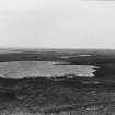
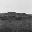
(Centred NK 086 574) Burgh of Rattray (NR) (Site of)
OS 6" map, (1959)
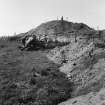
See also Rattray Castle Hill (NK 0880 5797), NK05NE 4.
The earliest mention of a town at Rattray was in connection with a gift of wax to St Mary's Chapel (NK05NE 2) between 1214 and 1233. It was created a Royal burgh in March 1563 but by 1654 the harbour was silting up, and by 1732 there was hardly a vestige of the town remaining. In 1888 only one house remained, and was used as a cattle shed.
J Milne 1900; Trans Buchan Fld Club 1900.
No trace.
Visited by OS (RL) 8 January 1969.
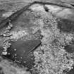
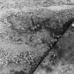
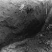
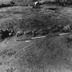
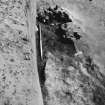
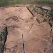
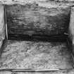
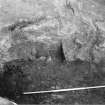
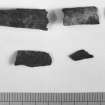
Large scale trial trenching in burgh area between castle (NK05NE 4) and church revealed possible medieval to late medieval occupation floor. Pottery kiln found with pottery at all stages of production; 13th century date indicated by partly fired imitation of Grimston type vessel in local fabric. Magnometer survey being undertaken to identify further kiln sites (cf NK05NE 5).
H K Murray and J C Murray 1986.
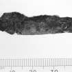
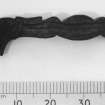
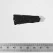
Open plan excavation of an area 20m by 40m took place in the burgh zone, near 1986 pottery kiln and over the area of 1986 magnotometer survey. This revealed 14th-15th century industrial complex covering two adjacent properties, one with extensive metal working, predominantly iron, the other with the pottery kiln and a series of smaller kilns, work floors and drainage systems.
H K Murray and J C Murray 1987.
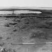
Excavations in 1989, in an area opposite the 13th-century burgh church revealed 14-15th century occupation. This area appears to have been a later extension of the built-up part of the burgh, and it is unlikely that the church was the initial focus of the settlement.
A series of three large areas was excavated in the field opposite the modern farm, where evidence of clay-walled domestic buildings was
found.
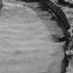
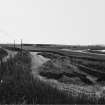
Trial trenching alongside the loch indicated the extent of salt marshes, possibly used for seasonal grazing.
H K and J C Murray 1989
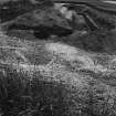
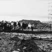
The sixth and final season of excavation of this deserted medieval burgh took place in July 1990.
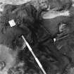
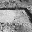
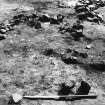
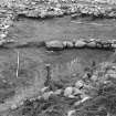
Work concentrated on the domestic area of the burgh. Property boundaries were found linking to those in the industrial area excavated in 1986/7. On one of the properties there had been a fairly substantial clay-walled building. This had burnt down, leaving burnt timbers and organic debris which appeared to be heather, but which is yet to be identified. The debris lay over the floor level, suggesting fallen roofing materials. The finds confirmed this building was likely to have been a dwelling.
On the N of the site a small hearth, possibly used for melting lead, a slight scatter of slag, and the physical links of some pottery, suggest contemporaneity with the industrial area excavated previously. The dwelling may have belonged to one of the craft workers.
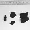
Post-excavation work is well in progress and examination of the local pottery shows a range of over 30 products, some fairly sophisticated. This will be one of the most comprehensive assemblages of local medieval pottery in the NE.
Sponsor: HBM
H K and J C Murray 1990
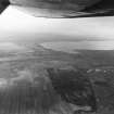
Visible on air photograph AAS/93/15/G30/31. Copy held by Grampian Regional Council.
Information from Mrs M Greig, Grampian Regional Council, March 1994.
Excavation (1985 - 1990)
Large scale trial trenching in burgh area between castle (NK05NE 4) and church revealed possible medieval to late medieval occupation floor. Pottery kiln found with pottery at all stages of production; 13th century date indicated by partly fired imitation of Grimston type vessel in local fabric. Magnometer survey being undertaken to identify further kiln sites (cf NK05NE 5).
H K Murray and J C Murray 1986.
Open plan excavation of an area 20m by 40m took place in the burgh zone, near 1986 pottery kiln and over the area of 1986 magnotometer survey. This revealed 14th-15th century industrial complex covering two adjacent properties, one with extensive metal working, predominantly iron, the other with the pottery kiln and a series of smaller kilns, work floors and drainage systems.
H K Murray and J C Murray 1987.
Excavations in 1989, in an area opposite the 13th-century burgh church revealed 14-15th century occupation. This area appears to have been a later extension of the built-up part of the burgh, and it is unlikely that the church was the initial focus of the settlement.
A series of three large areas was excavated in the field opposite the modern farm, where evidence of clay-walled domestic buildings was
found.
Trial trenching alongside the loch indicated the extent of salt marshes, possibly used for seasonal grazing.
H K and J C Murray 1989
The sixth and final season of excavation of this deserted medieval burgh took place in July 1990.
Work concentrated on the domestic area of the burgh. Property boundaries were found linking to those in the industrial area excavated in 1986/7. On one of the properties there had been a fairly substantial clay-walled building. This had burnt down, leaving burnt timbers and organic debris which appeared to be heather, but which is yet to be identified. The debris lay over the floor level, suggesting fallen roofing materials. The finds confirmed this building was likely to have been a dwelling.
On the N of the site a small hearth, possibly used for melting lead, a slight scatter of slag, and the physical links of some pottery, suggest contemporaneity with the industrial area excavated previously. The dwelling may have belonged to one of the craft workers.
Post-excavation work is well in progress and examination of the local pottery shows a range of over 30 products, some fairly sophisticated. This will be one of the most comprehensive assemblages of local medieval pottery in the NE.
Sponsor: HBM
H K and J C Murray 1990

