
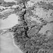
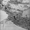
Larkhall, Millheugh, Millheugh Road, Millheugh Bridge


Road Bridge (Period Unassigned)
Site Name Larkhall, Millheugh, Millheugh Road, Millheugh Bridge
Classification Road Bridge (Period Unassigned)
Alternative Name(s) Avon Water; Broomelton Road; Sunnyside Road
Canmore ID 202335
Site Number NS75SE 69
NGR NS 75300 50685
Datum OSGB36 - NGR
Permalink http://canmore.org.uk/site/202335


- Council South Lanarkshire
- Parish Dalserf
- Former Region Strathclyde
- Former District Hamilton
- Former County Lanarkshire
NS75SE 69 75300 50685
Millheugh Bridge [NAT]
OS (GIS) MasterMap, September 2010.
This bridge carries Millheugh Road over the Avon Water on the SW side of Larkhall. The river here defines the boundary between the parishes of Hamilton (to the W) and Dalserf (to the E).
Information from RCAHMS (RJCM), 7 September 2010.

