
Pricing Change
New pricing for orders of material from this site will come into place shortly. Charges for supply of digital images, digitisation on demand, prints and licensing will be altered.
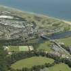
Aberdeen, Bridge Of Don


Road Block (Second World War), Road Bridge (19th Century) (1830)
Site Name Aberdeen, Bridge Of Don
Classification Road Block (Second World War), Road Bridge (19th Century) (1830)
Alternative Name(s) River Don; King Street
Canmore ID 20143
Site Number NJ90NW 231
NGR NJ 94621 09426
Datum OSGB36 - NGR
Permalink http://canmore.org.uk/site/20143


- Council Aberdeen, City Of
- Parish Aberdeen
- Former Region Grampian
- Former District City Of Aberdeen
- Former County Aberdeenshire
NJ90NW 231 94621 09426
Bridge of Don [NAT]
OS (GIS) AIB, May 2006.
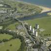
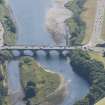
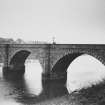
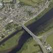
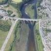
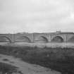
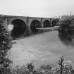
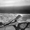
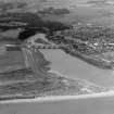
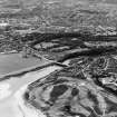
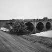
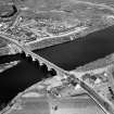
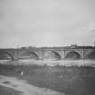
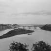
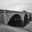
(Location cited as NJ 046 093). Bridge of Don. Built 1827-30, by engineers John Smith and Thomas Telford, and widened 1958-60. A seven-span bridge, built entirely of dressed stone, with segmental arches and rounded cutwaters extended up to form semi-hexagonal pedestrian refuges.
J R Hume 1977.
The flat roadway proved a considerable improvement over the steep Brig o' Balgownie (NJ90NW 4). Smith's masonry was duplicated in 1958 when the bridge was widened to accommodate heavier traffic.
(Air photographic reference cited).
NMRS, MS/712/83.
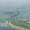
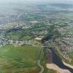
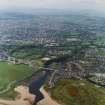
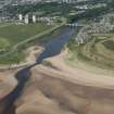
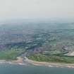
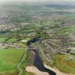
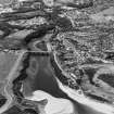
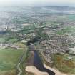
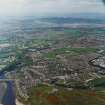
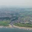
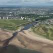
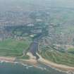
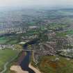
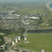
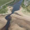
This bridge carries the A92 public road (King Street) over the River Don on the northern outskirts of Aberdeen. The river here forms the boundary between the parishes of Aberdeen (to the S) and Old Machar (to the N).
The location assigned to this record defines the midpoint of the structure. The available map evidence indicates that it extends from NJ c. 94643 09500 to NJ c. 94601 09349.
Information from RCAHMS (RJCM), 12 May 2006.
NMRS REFERENCE:
Aberdeen, Bridge of Don.
Foundation Stone laid May, 1827. (Apparently designed by John Gibb, Civil Engineer and the plan was approved by Telford. John Smith 1781-1852 was the "Resident Engineer".)
EXTERNAL REFERENCE:
Aberdeen, Bridge of Don.
Aberdeen: Aberdeen Public Library, Reference Dept: Slides: New Bridge of Don.
Fraser's Aberdeen Bridges and their story.
Milne's Aberdeen.
Munro's Old Landmarks of Aberdeen.
(Undated) information in NMRS.
Publication Account (2007)
Bridge of Don, Aberdeen
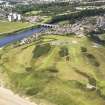
The Aberdeen to Peterhead road crosses the Don on a handsome
five-arched granite masonry bridge designed by Telford in 1827. Although John Rennie and Robert Stevenson submitted designs for this bridge some years earlier there was a considerable delay before Telford’s design, based on proposals by John Smith and John Gibb of Aberdeen, was finalised.
By the end of 1828, before the bridge was finished, both of the outer piers subsided, despite being supported on piled foundations. The north pier ultimately subsided 212ft and the south pier 112 ft. To remedy the situation it was necessary to take down the adjacent arches and the piers that supported them and to increase the bearing capacity of the foundation by driving an additional 69 piles of increased length in each foundation. It was 1830 before the remedial work and the bridgewere completed by John and Alexander Gibb ofAberdeen at the cost of £17 000. The bridge has given
no further trouble and has carried a progressively increased weight of traffic since its completion.
The segmental arches are each 75 ft span with a rise of 25 ft. The width of the original bridge was 24 ft but this was increased in 1956–59 to 66 ft by the construction of a new reinforced concrete arched bridge of similar profile adjacent to the existing bridge. Messrs. Considere Construction
Ltd and A. G. Booth, city engineer, designed the new bridge which was built by Messrs. H. M. Murray & Co. Ltd, Glasgow.
R Paxton and J Shipway, 2007.
Reproduced from 'Civil Engineering heritage: Scotland - Highlands and Islands' with kind permission from Thomas Telford Publishers
Note (29 January 2021)
A series of capped holes in the road surface at the S end of the bridge are visible in a Aerofilms oblique air photograph SAW014812 (flown 1948). These holes would have been for vertical rails to be slotted in to create a road block during the Second World War.
Information from Pillbox Study Group to HES (AKK) 29 January 2021

