
Following the launch of trove.scot in February 2025 we are now planning the retiral of some of our webservices. Canmore will be switched off on 24th June 2025. Information about the closure can be found on the HES website: Retiral of HES web services | Historic Environment Scotland
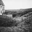
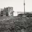
Dundarg Castle


Castle (Medieval), Fort (Period Unassigned)
Site Name Dundarg Castle
Classification Castle (Medieval), Fort (Period Unassigned)
Alternative Name(s) Dundargue Castle; Castle Of Dundarg; Cathair Of Abbordobor
Canmore ID 19958
Site Number NJ86SE 17
NGR NJ 8951 6491
Datum OSGB36 - NGR
Permalink http://canmore.org.uk/site/19958


First 100 images shown. See the Collections panel (below) for a link to all digital images.
- Council Aberdeenshire
- Parish Aberdour (Banff And Buchan)
- Former Region Grampian
- Former District Banff And Buchan
- Former County Aberdeenshire
NJ86SE 17 8951 6491
(NJ 895 648) Castle of Dundarg (NR) (remains of)
OS 6" map, (1959).
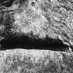
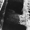
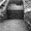
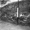
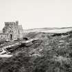
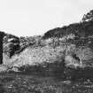
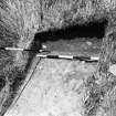
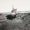
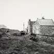
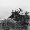
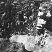
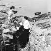
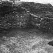
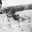
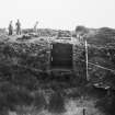
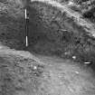
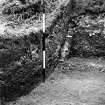
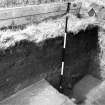
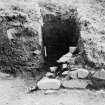
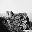
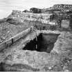
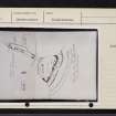
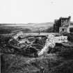
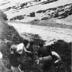
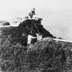
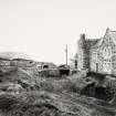
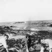
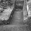
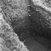
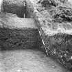
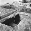
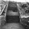
Dundarg Castle was built in the 13th century by the Comyns, and subsequently dismantled, probably by Bruce in 1308. It was rebuilt in 1334, but destroyed almost immediately, after a famous siege. Evidence of this double destruction was confirmed by excavations during 1911-12 and in 1950-51 when many medieval objects were found.
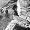
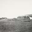
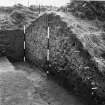
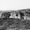
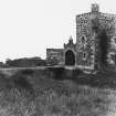
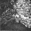
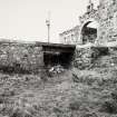
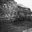
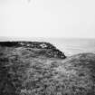
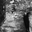
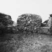
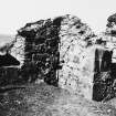
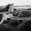
The only substantial part of the castle remaining is the inner gatehouse which survives to a height of about 18ft. The upper part was rebuilt about the middle of the sixteenth century, probably following the Coastal Defence Commission of 1550.
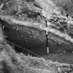
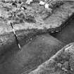
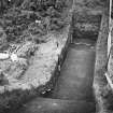
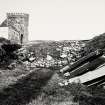
The castle stands within the ramparts of an Iron Age promontory fort, the inner ditch of which was widened to form the castle moat. Simpson (1954) says, with Wainwright's cautious agreement, that 'there can be little doubt that this fort was the "cathair" of Abbordobor which the Mormaer Bede the Pict made over to St Drostan, on his arrival at Aberdour in the 6th century AD, as narrated in the Book of Deer.' He suggests that the foundations of a building set at right angles to the other buildings in the inner ward were those of a Celtic chapel, and that other buildings in the inner ward may incorporate evidence which, together with the chapel, may point to the existence of a small Celtic monastery.
He further claims that a stretch of wall against which the 'chapel' abuts 'may be accepted as the vallum of the Celtic dun' (presumably that occupied by Bede the Pict).
The construction of the 'chapel' and adjoining building cut through a 'hard, bright-red clay floor' in which were possible post-holes, beneath a layer of midden refuse.
Among the finds made in 1911-12 was a Romano-British enamelled bronze button, bearing a swastika superimposed on a cross, dated by Professor Richmond to the 3rd-4th century AD.
W D Simpson 1954; 1959; W Beveridge 1914.
The fort and Dundarg Castle are as described and planned by Simpson (1954): there is insufficient evidence to confirm or deny the existence of a Celtic religious community.
Resurveyed at 1/2500.
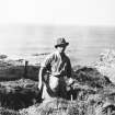
Visited by OS (RL) 9 March 1967.
(Location cited as NJ 8950 6480: nominated as Site of Regional Significance).
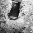
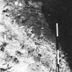
Remains of promontory fort: the prehistoric phase of Dundarg consists of the outer multiple ditch and banks, bone-rich midden deposits, (probably) post-holes on the promontory itself, together with worked flints and an enamelled bronze button with swastika symbol dated to 3rd or 4th century BC. The inner ditch of the fort was widened to form a later castle moat.
Simpson believed that Dundarg was the 'Cathair of Abbordobor' which Mormaer Bede the Pict made over to St Drostan on his arrival at Aberdour in the 6th century AD, as narrated in the Book of Deer. Simpson considered the Celtic chapel to be represented by foundations of of a building set at right-angles to other buildings in the inner ward; this, however, has not been proven.
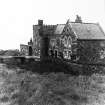
The castle was built by the Comyns in the 13th century and dismantled, probably by Bruce, in 1308. It was rebuilt in 1334 and destroyed almost immediately afterwards in a famous siege which was broken by the use of cannon, the first known example of such cannondale in Scotland. The inner gatehouse survives although there is some evidence that it was partially rebuilt and provided with gunloops in the 1550's. The site was finally abandoned in the mid 17th century and house was built on part of it in 1938.
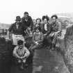
Archaeological excavation and/or survey work is recorded by D Fordyce (1912), W D Simpson (1950), F T Wainwright (1952) and N Fojut (1981).
[Air photographic imagery and bibliographic/newspaper references cited].
NMRS, MS/712/35, visited 9 May 1978.
NMRS NOTES
Dundargue Castle.
NMRS PLANS - I G Lindsay Collection W/68.
Non-Guardianship Sites Plan Collection, DC23420- Dc23425.
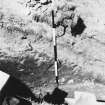
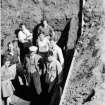
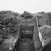
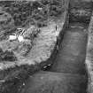
Excavation (1950 - 1951)
Evidence of the double destruction was confirmed by excavations during 1911-12 and in 1950-51 when many medieval objects were found.
The castle stands within the ramparts of an Iron Age promontory fort, the inner ditch of which was widened to form the castle moat. Simpson (1954) says, with Wainwright's cautious agreement, that 'there can be little doubt that this fort was the "cathair" of Abbordobor which the Mormaer Bede the Pict made over to St Drostan, on his arrival at Aberdour in the 6th century AD, as narrated in the Book of Deer.' He suggests that the foundations of a building set at right angles to the other buildings in the inner ward were those of a Celtic chapel, and that other buildings in the inner ward may incorporate evidence which, together with the chapel, may point to the existence of a small Celtic monastery.
He further claims that a stretch of wall against which the 'chapel' abuts 'may be accepted as the vallum of the Celtic dun' (presumably that occupied by Bede the Pict).
The construction of the 'chapel' and adjoining building cut through a 'hard, bright-red clay floor' in which were possible post-holes, beneath a layer of midden refuse.
W D Simpson 1954; 1959
Note (28 April 2015 - 31 May 2016)
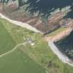
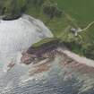
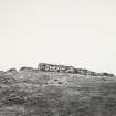
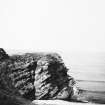
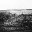
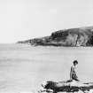
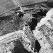
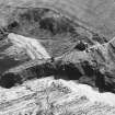
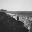
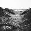
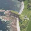
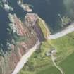
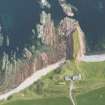
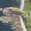
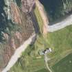
Dundarg Castle occupies a narrow promontory running out from the coastal escarpment for a distance of about 80m across the wave cut rock platform that forms the foreshore. At the landward end there is also an earthwork defence comprising a broad flat-bottomed inner ditch with a V-shaped outer ditch forming a rectilinear forework with a frontage of some 80m facing SSW and extending well beyond the margins of the promontory. To their rear, however, at the very root of the promontory, there are also traces of another ditch, which on excavation proved to be some 4m in breadth by 2m in depth and was accompanied by an internal rampart (Fojut and Love 1983). Though undated, this possibly forms part of an earlier defence cutting off a narrow finger of ground measuring about 100m in length and no more than 15m in breadth (0.12ha). The proximity of the parish church of Aberdour to the castle, lying little more than 1km to the WSW, has also led to the correlation of the site of the castle with a reference in the Book of Deer to a Cathair or fortified place hereabouts. The case for an earlier fortification here has also been sustained by the discovery of an enamelled button during earlier excavations at the castle (see discussion in Fojut and Love 1983), and to a lesser extent with a wooden ard-point probably of Iron Age date recovered from one of the ditches (Rees 1983). The case is my no means conclusive, and as far as the documentary reference is concerned it is worth noting that General William Roy's Military map of Scotland (1747-55) annotates a rectangular enclosure on the cliffs roughly midway between the castle and the church 'Danish Entrenchments', suggesting there were other traditions of ancient enclosures in the neighbourhood.
Information from An Atlas of Hillforts of Great Britain and Ireland – 31 May 2016. Atlas of Hillforts SC2983

