
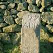
Aberdeen, Westfield Farm, Boundary Stone 22


Boundary Stone (18th Century) - (19th Century), Boundary Stone (Medieval) - (Post Medieval)
Site Name Aberdeen, Westfield Farm, Boundary Stone 22
Classification Boundary Stone (18th Century) - (19th Century), Boundary Stone (Medieval) - (Post Medieval)
Alternative Name(s) Aberdeen, March Stone 22
Canmore ID 19417
Site Number NJ80SE 52
NGR NJ 85155 03435
NGR Description Removed from NJ 8520 0342 to NJ 85155 03435
Datum OSGB36 - NGR
Permalink http://canmore.org.uk/site/19417


- Council Aberdeen, City Of
- Parish Peterculter
- Former Region Grampian
- Former District City Of Aberdeen
- Former County Aberdeenshire
NJ80SE 52 Moved from 8520 0342 to 85155 03435
See also NJ90NW 135.
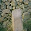
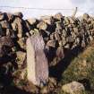
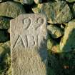
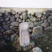
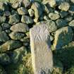
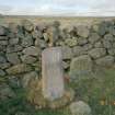
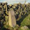
Situated on a knoll W of Westfield Farm. Marked 22 ABD. A cup-marked boundary stone is noted here in 1698.
(OS 25-inch map, 1965, shows that this stone has been moved from its original site: NJ 8520 0342 to the side of the field, at NJ 8515 0343).
D B Gunn 1929; HBD 1967.
This granite boundary stone is situated immediately S of a drystone dyke 235m W of Westfield Cottage. Rectangular in section, it measures 0.33m in breadth by 0.17m in thickness and 0.95m in height. The top of its S face is bevelled and bears the incised letters ABD below the number 22. Nothing is now visible of the cupmarked boulder bearing a single large cupmark, which once accompanied the boundary stone.
Visited by RCAHMS (JRS, ATW), 25 February 1997.
J Cruickshank and D B Gunn 1929.

