
Following the launch of trove.scot in February 2025 we are now planning the retiral of some of our webservices. Canmore will be switched off on 24th June 2025. Information about the closure can be found on the HES website: Retiral of HES web services | Historic Environment Scotland
Logie Durno


Temporary Camp (Roman)
Site Name Logie Durno
Classification Temporary Camp (Roman)
Alternative Name(s) Durno; Westerton; Easterton
Canmore ID 18107
Site Number NJ62NE 31
NGR NJ 6985 2718
NGR Description Centred NJ 6985 2718
Datum OSGB36 - NGR
Permalink http://canmore.org.uk/site/18107


- Council Aberdeenshire
- Parish Chapel Of Garioch
- Former Region Grampian
- Former District Gordon
- Former County Aberdeenshire
NJ62NE 31 centred 6985 2718
Extends onto map sheet and noted by Aberdeenshire Archaeological Service under site number NJ72NW 50.
For discovery of Neolithic pottery during excavations at NJ 702 272, see NJ72NW 64.
For possible ring-ditch and other cropmarks at Westerton (NJ 695 274) and farmhouse and steading of Westerton (NJ 6952 2733), see NJ62NE 55 and NJ62NE 56 respectively; both these features fall within the area of the temporary camp.
For (possibly associated) linear cropmarks at NJ 697 267, see NJ62NE 109.
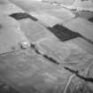
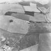
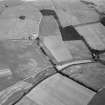
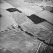
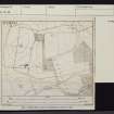
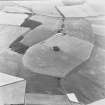
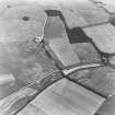
(Location cited as centred NJ 699 572 [NJ 699 272]). The discovery (in July 1975) of this large camp came as something of a surprise but two seasons of reconnaissance and two short spells of digging have established the greater part of the plan, although there are no visible surface traces. It is situated on ploughed but uneven ground to the NE of the River Urie and 500ft (152m) at its nearest point. The minimum area of the camp is 141.25 acres (57.2 ha) and the most likely area some 3 acres more (58.4 ha altogether), making this the largest camp known N of the Antonine Wall.
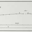
The whole of the SW side, of length 3230ft (984m) is known, and includes two wide gates, each with a traverse. The exact position of the S sector of that side and of the rounded S angle has been determined by digging; it is V-shaped in section, 11ft (3.4m) broad and up to 4ft 6ins (1.37m) deep. A change in direction through some 32 degrees occurs at the northernmost gate in this side.
Much of the NW side, 1930ft (588.4m) long, has been observed from the air while a few trenches fixed the position of the central gate, 63ft (19.2m) wide, and its traverse.
Rather less than half the NE side, including the more northerly of the two gates was visible from the air, the rest being under well-established pasture. Digging located the ditch next to Easterton of Logie steading and found the second gate on that side.
Only 200ft (61m) of the SE side remained near the S angle, the adhacent ditch having been apparently ploughed out on the moderately steep slope.
On the NE side, the ditch became progressively shallower towards Easterton, running out into the ploughsoil. Some 200ft (61m) W of Easterton, several ditch-sections revealed an irregular profile in an area of rock knolls and outcropping gabbro both in the paddock SE of the steading and further SW (across the lane) in rough ground which had previously formed part of a wood. Digging had evidently stopped when rock was encountered. Trenches SE of the steading revealed no ditch; a rampart of earth and boulders may have sufficed around this length of the perimeter. The short proven length of the SE side (parallel to the NW side) may be assumed to have contnued to a SE gate within the wood on the crest of a ridge. The lie of the ground and the disposition of the known gates suggests that the E angle lay a few hundred feet SE of Easterton.
J K St Joseph 1977.
(NJ 699 272). The outline of a Roman camp about 140 acres (56.7 ha) in extent has been partly established by air reconnaissance and field work, including sectioning of ditches, between 1975 and 1977, at Durno. It occupies uneven ground, is irregular in shape, and most of the SE side including the SE angle, has yet to be established, but its topographical setting, especially in relation to Bennachie (NJ 65 SS), strongly suggests that it may be the camp associated with the battle of Mons Graupius in 83 AD.
(Full description of camp and discussion of battle).
J K St Joseph 1978.
(AAS NJ72NW 50: location cited as NJ 701 271). This Roman temporary camp is situated in pastureland on an uneven ridge from which bedrock protrudes in places; it measures at least 141.25 (and possibly as much as 144) acres in extent. The altitude is between 110 and 125m OD.
(Comprehensive list of newspaper references and air photographic imagery citations).
Information from Aberdeenshire Archaeological Service, June 1997.
NMRS, MS/712/19 and MS/712/36.
CUCAP air photographic imagery:
26 July 1975 BVD 85-96 and 99-102, BVE 1-12
26 July 1975 K17-AJ 5-15 (vertical)
28 July 1975 K17-AJ 133-5 and 144-6 (vertical)
21 July 1976 CAF 28-49 and 52-3
20 July 1977 CDE 19-28
31 July 1977 CDV 57-9 and 64
(Undated) information in CUCAP card index.
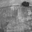
Nothing is visible of the defences of this camp, which occupies an area of mixed woodland, pasture and arable cultivation.
Visited by RCAHMS (JRS), 20 March 1996.
Scheduled as 'Durno, Roman temporary camp, 420m ESE of Westerton...'
Information from Historic Scotland, scheduling document dated 5 March 2008.
Publication Account (17 December 2011)
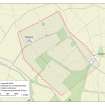
The camp at Logie Durno was discovered from the air by St Joseph in 1975 (St Joseph 1977: 141), just to the east of the River Urie, some 5km from Mither Tap of Bennachie, which dominates the surrounding landscape. It lies on ground that slopes quite significantly, with a 35m height-difference between the highest and lowest points within the camp; its perimeter is slightly irregular in form. The farms of Easterton and Westerton lie within the camp, which is now under arable and improved pasture. Nothing appears to survive of the camp above ground, although a very low swelling on the northeast side (not depicted on illus 169) may represent the ploughed out remains of a rampart.
Part of the camp has been visible as cropmarks, with much of the rest of the perimeter established by excavations between 1975 and 1977 and depicted as a dashed line on illus 169 (St Joseph 1978a). It measures about 959m from north-west to south-east by about 653m transversely, enclosing an area of some 58.6ha (almost 145 acres), and is the largest camp north of the Forth–Clyde isthmus. The excavated ditch was usually V-shaped, up to 3.65m in width and 1.4m in depth (St Joseph 1978a: 273). Three tituli are clearly visible on the air photographs, two in the south-west side (where there is a significant change of angle at the northern gate) and one on the northern part of the north-east side, also at a change of angle. Two further tituli were recorded through excavation, in the southern part of the north-east side and the centre of the north-west side. That on the north-west side had a shallow ditch, some 0.5m in depth and set about 15m from the entrance. Illustration 169 includes the results from St Joseph’s excavations (1978a).
St Joseph used the evidence of Logie Durno’s size and location to build up an argument for the area as the location of Tacitus’ famed battle of Mons Graupius, with nearby Bennachie as the titular hill (1978a).
R H Jones.

