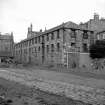
Edinburgh, 19 St Leonard's Lane, St Leonard's Station And Coal Depot, Goods Shed
Cafe (20th Century) - (21st Century), Distillery (21st Century), Goods Shed (19th Century) - (20th Century)
Site Name Edinburgh, 19 St Leonard's Lane, St Leonard's Station And Coal Depot, Goods Shed
Classification Cafe (20th Century) - (21st Century), Distillery (21st Century), Goods Shed (19th Century) - (20th Century)
Alternative Name(s) Edinburgh And Dalkeith Railway; Formelry Lin 23; Engine Shed Cafe; Innocent Railway Engine Shed
Canmore ID 180595
Site Number NT27SE 4360
NGR NT 26541 72860
Datum OSGB36 - NGR
Permalink http://canmore.org.uk/site/180595
- Council Edinburgh, City Of
- Parish Edinburgh (Edinburgh, City Of)
- Former Region Lothian
- Former District City Of Edinburgh
- Former County Midlothian
NT27SE 4360.00 26541 72860
NT27SE 4360.01 26525 72869 Outbuilding
NT27SE 4360.02 26516 72864 Gate-piers
See also NT27SE 3979, NT27SE 553, NT27SE 589, NT27SE 2735, NT27SE 4356, NT27SE 4417, NT27SE 4418.
The location of this shed is visible on the 1st edition of the OS 6-inch map (Edinburghshire 1855, sheet 2), on the 2nd edition of the OS 6-inch map (Edinburghshire, sheet iiiSE) and on the current edition of the OS 1:10000 map (1989).
Information from RCAHMS (MD) 13 July 2001.
Standing Building Recording (April 2017 - April 2019)
NT 2654 7286 A programme of work comprising a historic building record and a watching brief on all groundworks was carried out between April 2017 and April 2019. The building represented the remains of an early 19th century engine/storage shed associated with St Leonards Station and Coal Depot. The external elevations of the three-storey category B listed building were original and in good condition. The building had recently been used as a bakery and café, and therefore the internal spaces had been altered and modified.
The watching brief monitored ground reduction works both within the building and external areas. The remains of a stone wall were revealed below the modern concrete floor within the building. This wall likely relates to 18th century garden boundary walls depicted on mapping of the period. Elsewhere the monitoring revealed a variety of deposits associated with ground disturbance relating to 19th and 20th century activity in the area.
Information from D. Wilson - Headland Archaeology
(Source: DES Vol 20)
OASIS ID: headland1-371291


