
Wheel Causeway


Track (Period Unassigned)
Site Name Wheel Causeway
Classification Track (Period Unassigned)
Alternative Name(s) Hare Cairn, Spar Plantation
Canmore ID 179517
Site Number NT60NW 30
NGR NT 6072 0710
NGR Description From NT 6092 0500 to NT 6000 0919
Datum OSGB36 - NGR
Permalink http://canmore.org.uk/site/179517


- Council Scottish Borders, The
- Parish Southdean
- Former Region Borders
- Former District Roxburgh
- Former County Roxburghshire
NT60NW 30 from 6092 0500 to 6000 0919. LIN 3.
Formerly LIN 529.
Old Road (probably in use during the 13th Century.)
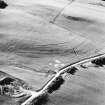
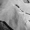
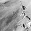
On the S slope of Wardmoor Hill (NT 6058 0628) two hollow tracks can be followed, one on each side of the foundations of a demolished turf dyke and thence for the rest of the distance there is nothing to remark beyond further hollow tracks, often poorly defined, and stretches of grassland lightly scored by the passage of animals. Between the heads of the Wolfehopelee Burn (NT 6058 0719) and Battling Sike (NT 6074 0724), and before splitting up and entering the improved lands, the road passes through a linear earthwork (NT60NW 13) (at NT 6068 0719) in two main tracks.
Alternative Northward extensions, Southdean and Jedburgh Parishes:
From NT 6068 0719 the Wheel Causeway splits into at least three branches, and as these immediately enter enclosed land, and have been subject to agricultural use in recent times as well, no doubt, as to droving, no conclusions can safely be drawn about this part of the Causeway proper in its original form.
One of the three branches leads "through trig. station 1125, along the E flank of Wolfelee Hill (NT 5971 0847), and thence swings NW to join the highway at Cleuch Head (NT 5938 1008). On the first edition OS 6 inch (Roxburgh 25 SW) the branch mentioned above has been recorded as a part of the Wheel Causeway proper as it follows the approximate line as published on the OS map.
Information from OD (DT) 1 Nov 1957.
RCAHMS 1956.
NT 608 061 to NT 609 055 Scheduled
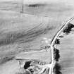
From NT 609 050 the Causeway runs northwards as a mutilated hollow way through the Wauchope Forest to the sheepfold at NT 609 054 where it emerges into open moorland. On the S slope of Wardmoor Hill two hollow tracks can be followed on each side of a demolished turf dyke. For the rest of the distance to NT 6068 0719 the road is represented by hollow tracks, often poorly defined. At NT 6068 0719 the Causeway is said to divide into three branches:
1) the Causeway itself leads through NT 605 075 and along the E flank of Wolfelee Hill to NT 6000 0919 where it leaves this map sheet. There is no trace of the road between NT 606 072 and NT 605 075.
2) A branch runs northwards through a plantation to NT 6097 0699 and from there it can be traced as a curving hollow way c.6m broad to NT 607 078. It then continues northwards as a slight terrace for about 250m when all traces are lost in the vicinity of a quarry. No traces could be found beyond this point.
3) Another branch leads past Highlee Hill (NT 616 079) and Lustruther farm (NT 6241 0922) to the road junction at NT 6277 0934. No traces could be found beyond this point.
Two further branches of the Causeway are said to run northwards from Jedhead (NT 6243 0500), one on either side of the Jed Water. One follows the course past Westshiels (NT 6227 0645) to Dykeraw Tower (NT 6283 0906). No traces could be found beyond this point. The other follows the course over Millmoor Rig (NT 632 067) and leaves the map sheet at NT 699 094.
Information from OS (WDJ) 5 Oct 1960.

