
Yesnaby, Broch Of Borwick


Broch (Iron Age), Midden (Period Unassigned), Unidentified Pottery (Iron Age)
Site Name Yesnaby, Broch Of Borwick
Classification Broch (Iron Age), Midden (Period Unassigned), Unidentified Pottery (Iron Age)
Alternative Name(s) Yescanaby
Canmore ID 1660
Site Number HY21NW 1
NGR HY 2241 1678
Datum OSGB36 - NGR
Permalink http://canmore.org.uk/site/1660


- Council Orkney Islands
- Parish Sandwick
- Former Region Orkney Islands Area
- Former District Orkney
- Former County Orkney
HY21NW 1 2241 1678.
(HY 2241 1678) Brough of Borwick (NR)
O.S.6"map, Orkney, 2nd ed.,(1903).
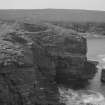
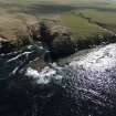
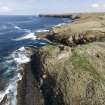
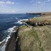
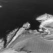
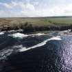
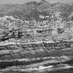
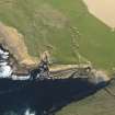
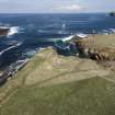
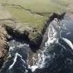
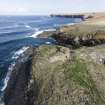
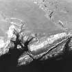
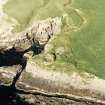
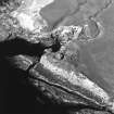
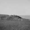
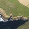
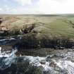
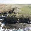
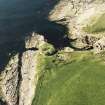
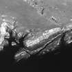
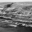
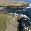
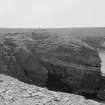
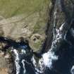
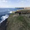
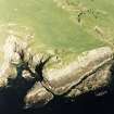
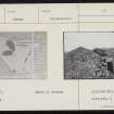
The Broch of Borwick occupies the summit of a promontory, 80-90ft above the sea, with a small sandy bay on its south side. The pormontory must have originally been cut off from the land by an outer wall which ran along the edge of a shallow depression some 82ft broad, thought by some to be artificial. At the point where this wall met the south cliff there are the remains of a building with a chamber. According to Watt, in 1881 the whole of the promontory with- in this outer wall was covered with the remains of 'out- buildings'. Some of these buildings were traced by the RCAHMS. "... at a distance of some 60ft from the tower ..."
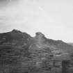
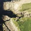
Before excavation in 1881 (W G T Watt 1882) the broch appeared as a turf-covered mound 15-20 ft high. Watt found that the wall of the broch varied from 11ft 5 ins to 16ft in thickness and stood up to at least 16ft in height, enclosing an area about 24ft in diameter. This was reduced by secondary building to a court about 16ft in diameter, the later construction standing on a three-foot depth of broch debris. An analogous structure at Dun Mor Vaul, Tiree ( ) produced 2nd century AD material.
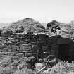
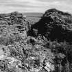
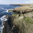
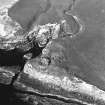
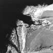
The RCAHM found in 1937 that the seaward side of the broch had fallen and that the walls stood to about 8 1/2 ft high, and that there was no trace of any internal detail.
RCAHMS 1946; E W MacKie 1965.
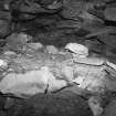
The Broch of Borwick is generally as described by the RCAHMS.The interior is a mass of tumbled debris, where a length of only c.1.5m. of the walling of the secondary structure could be found, on the north side. The outbuildings and wall could be traced only for very short lengths and the building at the junction of the wall and the south cliff is now almost unrecognisable because of cliff erosion.
Visited by OS(RL) 15 May 1966.
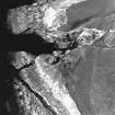
The outer face of the broch tower has been removed by marine erosion for a distance of c.4m on the S side, with a further 2-3m on either side of the gap surviving to basal course only.
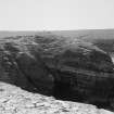
A midden, lying on bedrock, has been revealed 9m NE of the tower in t he cliff section. This contained ash and 10 fragments of Middle Iron Age pottery, fragments of animal bone, a piece of perforated flagstone, and shells. A floot tank with basal slab lies 3m W of the midden and contained a scatter of earth and rabbit bone. The possible remains of a wall running E-W overlie the tank and midden.
The pottery has been deposited in Tankerness House Museum, Kirkwall ( Accession no. THM 1983. 137), along with a fuller report of the site. The other finds were left in situ.
D Lynn and B Bell 1983.
The midden, noted in 1983 produced six further fragments of middle Iron Age pottery, including two rim sherds. A bone fragment (possibly a sheep ulna) also found had been shaped to a point and polished. Its length is 133mm.
Further erosion of the S face of the broch tower had taken place, together with the exposure of further indeterminate structural remains to the SE of the broch. A full report has been deposited in Tankerness House Museum, Kirkwall, with the finds. (Accession nos: pottery fragments (all) THM 1987.127, bone point THM 1987.128).
D Lynn and B Bell 1987.
'The Orcadian' extensively describes the excavation of Broch of Borwick, including a sea-level chamber, between December 1-15 1906. The paper describes the site again in 1910.
M Howe 2006
Publication Account (1996)
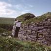
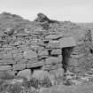
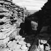
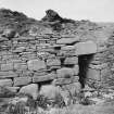
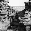
The broch-builders chose a place of natural strength, not only on account of the steep cliffs but also because of its proximity to a freshwater burn and a landing-place for boats. The landward side was originally protected by a wall, and 19th century excavations revealed traces of outbuildings and artefacts showing that the occupation of the site continued into the mid 1st millennium AD. Severe erosion has destroyed the seaward half of the broch, but the eastern half is well preserved and includes the entrance with its door-check half-way long the passage and guard-cell opening off the northern side of the passage. Above the roofing slabs is a small cell. The outer wall-face of the broch is well built, using some massive boulders at the base and smaller slabs above; it survives to a height of almost 3m.
Information from ‘Exploring Scotland’s Heritage: Orkney’, (1996).
Magnetometry (April 2008 - November 2011)
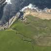
HY 22945 16391 (centred on) An extensive walkover survey, covering c750ha, was undertaken between April 2008 November 2011 over an area of Yesnaby and Skaill Bay on the W coast of mainland Orkney, as part of PhD research. More than 200 sites were identified ranging from Bronze Age burnt mounds to post-medieval buildings and enclosures. Most significantly an extensive upland field system was identified around the probable Bronze Age roundhouse on the Peerie Hill. A targeted gradiometer survey was undertaken on three sites within the survey area.
The gradiometer survey of c2.2ha covering the Peerie Hill roundhouse and surrounding field system was of limited success due to the effect of peat growth and soil erosion. However, it did suggest that the roundhouse had at least two phases of occupation. A survey of a c3.75ha area inland of the Broch of Borwick (HY21NW 1) recorded responses indicative of rig and furrow, and a series of post-medieval field boundaries were also noted. However, the level of magnetic enhancement suggests that these features are reworking substantial deposits of anthropogenic soil, which appear to be associated with the broch. A survey of c1ha on the promontory fort at the Brough of Bigging (HY21NW 7) revealed clusters of apparently non-domestic responses, which seem to be related to the cist-like features and deposits of burnt material that are eroding from the NW side of the promontory.
Report: Orkney SMR and RCAHMS (intended)
Funder: Orkney College UHI
Orkney College UHI, 2011
Note (24 February 2015 - 1 November 2016)
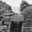
The Broch of Borwick is at first sight the stump of a relatively well-preserved broch standing spectacularly at the tip of a precipitous promontory, but it has not only suffered at the hands of an antiquarian excavator, and the cliff-faces are steadily receding on the N and SW where the wall is collapsing into the abyss. The broch measures about 8.2m in diameter within a wall between 3.5m and 4.6m in thickness and still presents up to 2.4m of neatly coursed outer face to either side of its checked entrance on the SE, which also has a guard chamber. There was evidently a settlement outside the broch, but it is difficult to make any sense of the remains visible today, and nor of any other defences barring access on the landward side. Nevertheless, in the account of his excavations, in which he dug down through a mound over 6m high, William Watt describes an outer wall cutting off the promontory that was 1.8m thick at the base and tapered upwards to about 1m at a height of 2.7m. Confusingly he asserts that this wall was 'founded in the moat' (Watt 1882, 447) 15m to 18m broad that he believed also traversed the approaches to the promontory, of which little coherent trace can now be seen. The enclosed area was roughly triangular, measuring perhaps 50m from NE to SW immediately to the rear of the wall by at least 40m transversely (0.11ha).
Information from An Atlas of Hillforts of Great Britain and Ireland – 01 November 2016. Atlas of Hillforts SC2845
Publication Account
HY21 1 BORWICK (‘Broch of Borthwick’, ‘Bur-wick’)
HY/22411678
Solid-based broch in Sandwick, on a cliff promontory next to flat farmland. The site, originally a green mound, was explored by W.G.T. Watt in 1881, but his description of the broch he discovered is not as clear as it might have been, mainly because he published no plan of the site.
The broch stands on top of a cliff promontory which falls 18.3-24.4 m (60 - 80 ft.) sheer to the sea and rolling, cultivated land runs right up to it. A small stream runs past the site immediately to the E. The promontory was cut off from the flat land beyond by an outer wall; a shallow depression immediately beyond it may be a ditch. Outbuildings were found between the wall and the broch.
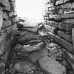
In 1881 the wall of the ruined tower stood to a height of 3.4 m (11 ft.) and in places reached 4.9 m (16 ft.). The Commission measured the wall height as 2.6 m (8.5 ft.) in 1935 [3], so considerable dilapidation occurred during the half century after the excavation; the building now seems to be fairly stable. The entrance passage, still lintelled over, was 5.57 m (18 ft. 3 in.) long with door-checks each formed of a slab set on edge 2.97 m (9 ft. 9 in.) from the outside; the actual broch entrance is only 4.3-4.6 m (14-15 ft.) long as a secondary wall had been added to the inner face at some stage (below). A guard cell opened off the right of the passage; the door was 1.57 m (5 ft. 2 in.) high but rubble now chokes the passage to within 45 cm (18 in.) of its lintels. There are no clear signs of bar-holes behind the door. The passage is lintelled only down as far as the door frame and there is a void or chamber above these; this void is taken here as an indication that the structure is a hollow-walled broch. If the building stood to 4.9 m (16 ft.) in 1881 Watt should have uncovered traces of the upper gallery and the intra-mural stair on the wall head but he makes no mention of any such features; presumably the stair started at first floor level but was not observed.
Watt cleared the debris from the interior and found under the rubble "unctuous matter" containing ashes, bones and shells mixed with clay to a depth of 60 cm (2 ft.) or more. Underneath this layer was a layer of small flat stones from 60-90 cm (2-3 ft.) thick and under this the broch floor. Some flagstones on edge were just showing above the "unctuous matter" and "crude inner circular walls" rested on the 90 cm (3 ft.) thick basal stone layer. This presumably refers to the secondary wall round the interior shown on the Commission's plan; this is 2.58 m (8.5 ft.) thick at the entrance.
There seem to have been secondary oblong chambers in the interior, presumably formed of the flags on edge; a secondary stairway on the east side is also described, founded on the basal stony layer. No signs of mural galleries, stairs or chambers were apparent then and none are now. The basal course of the outer wall face projects forward slightly from those above.
From the verbal description it sounds as though the interior stratigraphy of the broch showed a mass of small masonry debris on the original floor level - perhaps derived from the partial demolition of the upper walls - with a secondary wall (perhaps built of the larger stones from the demolished wall) built round the interior on top of it. The "unctuous matter" then accumulated during the subsequent, secondary habitation of the broch. The composite bone comb found would fit into the late Iron Age phase of this secondary occupation, perhaps in the 6th or 7th centuries AD, as at Burrian broch on North Ronaldsay (HY75 1) and in the late levels in Dun Cuier on Barra (NF 60 3). The long-handled combs are character-istic middle Iron Age broch period artefacts (visited 19/7/63 and in 191985).
In 1983 a midden lying on bedrock was found in the cliff face 9 m NE of the broch; it contained Iron Age pottery, ash and animal bones [4].
Dimensions: External diameter 16.8 m (55 ft.): internal 8.2 m (27 ft.). The wall thickness varies from 3.49 m (11 ft. 5 in.) on the west through 4.3-4.6 m (14-15 ft.) on the south and east to 4.9 m (16 ft.) on the N. The walls proportion may thus be about 47.3%. The entrance passage was 1.58 m (5 ft. 2 in.) high, 1.05 m (3 ft. 5 in.) wide at the base at the exterior, narrowing to 90 cm (2 ft. 11 in.) at the checks; it then widened again to 1.53 m (5 ft.).
Finds [2]: the artefacts found are given no provenance but it may be supposed that many of them came from the "unctuous" earth -- the debris of the secondary occupation of the tower. The more important include, of bone, 2 long- handled bone combs (one fish-tailed), 1 composite, single-edged round-backed comb, 1 single-edged non-composite comb, 1 broken double-edged composite comb, 1 small whale vertebra cup, 1 socketed handle, 3 needles or bodkins (1 decorated), a spindle whorl, antler tines, a cetacean ivory toggle and a possible antler bridle cheek-piece.
Stone: objects included some thin, round stone discs, probably pot lids, a polished gaming piece, a possible stone lamp, a perforated whetstone, hammerstones, some Skaill knives and choppers, and some querns (type not stated). A full list of the finds has been compiled [5].
Iron: 1 rod.
Pottery: 1 native sherd.
Sources: 1. OS card HY 21 NW 1: 2. Watt 1882, 442-50: 3. RCAHMS 1946, 2, no. 679, 252-3 and figs. 344, 345 (plates) and 347 (plan): 4. D. Lynn and B. Bell in Discovery and Excavation Scotland 1983, 19: 5. Hedges et al. 1987, 83-5: Fraser 1924, 26.
E W MacKie 2002

