
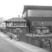
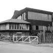
Motherwell, Park Street, Signal Box And Level-crossing


Level Crossing (19th Century)-(20th Century), Signal Box (19th Century)-(20th Century)
Site Name Motherwell, Park Street, Signal Box And Level-crossing
Classification Level Crossing (19th Century)-(20th Century), Signal Box (19th Century)-(20th Century)
Canmore ID 164309
Site Number NS75NE 29
NGR NS 7560 5691
NGR Description centred on signal box
Datum OSGB36 - NGR
Permalink http://canmore.org.uk/site/164309


- Council North Lanarkshire
- Parish Dalziel
- Former Region Strathclyde
- Former District Motherwell
- Former County Lanarkshire

