
Bridge-end, Old Bridge Of Avon


Road Bridge (18th Century) (1800)
Site Name Bridge-end, Old Bridge Of Avon
Classification Road Bridge (18th Century) (1800)
Alternative Name(s) Ballindalloch Castle; Dalnashaugh; River Avon
Canmore ID 16001
Site Number NJ13NE 21
NGR NJ 18331 35886
Datum OSGB36 - NGR
Permalink http://canmore.org.uk/site/16001


- Council Moray
- Parish Inveravon
- Former Region Grampian
- Former District Moray
- Former County Banffshire
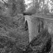
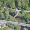
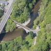
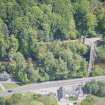
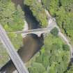
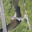
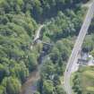
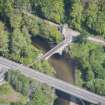
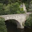
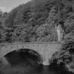
High single span bridge with smaller additional arch at east end (north bank). Designed by George Burn, architect, dated 1800. Now only open for walkers.
A high, single span bridge, designed by the architect George Burn, crosses the River Avon. Opened in 1800, it is now used only by walkers.
The bridge is constructed of rubble, with the arch rising from a smooth stone abutment at the south bank, and with a pier built of similar stone at the north bank. Drainage vents run across the top of the bridge, which is now braced by iron ties.
There are two plaques on the south face of the bridge. The upper plaque records the building of the bridge by General Grant of Ballindalloch, while the lower marks the highest point reached by the river during the flood of 1829, which raised the water by about 7m.
Text prepared by RCAHMS as part of the Accessing Scotland's Past project
NJ13NE 21 18331 35886
Bridge of Avon [NAT]
OS (GIS) MasterMap, September 2010.
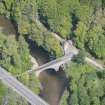
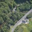
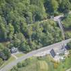
For (successor) New Bridge of Avon (NJ 18320 35833), see NJ13NE 51.
(Location cited as NJ 184 354). Bridge of Avon, Dalnashaugh, probably early 19th century. A single segmental rubble arch.
J R Hume 1977.
The (old) Avon bridge is of mellow, dark stone Held now with metal stays, a rubbled bridge with narrow voussoirs and rounded cutwaters; the main arch is strong and graceful. It is now used only by walkers, and has become an adjunt to Ballindalloch Castle, the gatehouse (NJ13NE 4.03) of which is on the E Bank.
G Nelson 1990.
This bridge apparently carried the former line of the A95 public road over the River Avon. The replacement (new) bridge (NJ13NE 51) is situated 50m to the SW, at NJ 18320 35833.
Information from RCAHMS (RJCM), 7 September 2010.
Photographic Survey (4 September 2013)
Photographed for the Listed Buildings Area Survey 2013-14.

