
Following the launch of trove.scot in February 2025 we are now planning the retiral of some of our webservices. Canmore will be switched off on 24th June 2025. Information about the closure can be found on the HES website: Retiral of HES web services | Historic Environment Scotland
Lewis, Borve Bridge


Road Bridge (Period Unassigned)
Site Name Lewis, Borve Bridge
Classification Road Bridge (Period Unassigned)
Alternative Name(s) Glendale; High Borve; Five Penny Borve
Canmore ID 156593
Site Number NB45NW 65
NGR NB 41125 56211
Datum OSGB36 - NGR
Permalink http://canmore.org.uk/site/156593


- Council Western Isles
- Parish Barvas
- Former Region Western Isles Islands Area
- Former District Western Isles
- Former County Ross And Cromarty
NB45NW 65 41125 56211
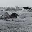
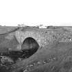
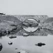
(Location cited as NB 412 563). Bridge, Borve, mid 19th century. A single rubble segmental arch.
J R Hume 1977.
This bridge carries the A857 public road over the Borve River between the settlements on High Borve (to the NE) and Five Penny Borve (to the SW). The house of Glendale is adjacent (on the E).
Information from RCAHMS (RJCM), 29 April 2005.
The original 19th century bridge has now been superseded by a new structure situated about 18m to the SE and which now carries the realigned A857 road . The older bridge no longer carries any road traffic and is now blocked by posts (depicted on current OS 1:2500 scale digital map).
The 19th century bridge is is not depicted on the 1st Edition of the OS 6-inch map (Island of Lewis, Ross-shire, sheet 5, 1853), which shows only a footbridge and ford. However by the date of publication of the 25-inch scale plan, the bridge is depicted and the road is shown realigned. The site of the ford and stepping stones was approximately 20m upstream from the new bridge. The 25-inch scale map also depicts a series of stepping stones upstream from the ford.
A footbridge is depicted on the 1st edition OS map (ibid) immediately to the W of the 19th century bridge, which is also visible on RCAHMS photograph RC 1405. Only the stone piers of the footbridge survived on the date of visit
Visited by RCAHMS (DE), 4 August 2005

