
Following the launch of trove.scot in February 2025 we are now planning the retiral of some of our webservices. Canmore will be switched off on 24th June 2025. Information about the closure can be found on the HES website: Retiral of HES web services | Historic Environment Scotland
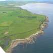
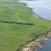
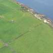
Port A' Chaistell


Enclosure (Period Unassigned)(Possible)
Site Name Port A' Chaistell
Classification Enclosure (Period Unassigned)(Possible)
Canmore ID 15629
Site Number NH98NW 7
NGR NH 9304 8709
Datum OSGB36 - NGR
Permalink http://canmore.org.uk/site/15629


- Council Highland
- Parish Tarbat
- Former Region Highland
- Former District Ross And Cromarty
- Former County Ross And Cromarty
NH98NW 7 9304 8709.
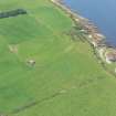
(NH 9304 8709) Roman camp (R) (Site of)
OS 6" map, Ross-shire, 2nd ed., (1907)
The Rev Grant, minister of Boharn (1822) described, near Port a' Chaistell, "a beautiful square fortification of about 100 paces of a side," considered by Crawford (1949) to be probably that indicated on OS 6" map, as the site of a Roman Camp. It had apparently been defaced by 1872 (ONB 1872) during land reclamation, but Crawford thinks there may be some traces of it still visible. He had not, however, visited the site.
Grant 1822; Name Book 1872; O G S Crawford 1949.
No trace.
Visited by OS (A A) 19 September 1972.

