
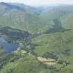
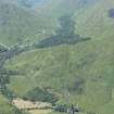
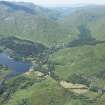
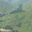
Kinlocheil


Township (Period Unassigned)
Site Name Kinlocheil
Classification Township (Period Unassigned)
Canmore ID 145130
Site Number NM97NE 11
NGR NM 980 790
NGR Description Centred on NM 980 790
Datum OSGB36 - NGR
Permalink http://canmore.org.uk/site/145130


- Council Highland
- Parish Kilmallie
- Former Region Highland
- Former District Lochaber
- Former County Inverness-shire
Note
A crofting township comprising two unroofed, seventeen roofed buildings and their associated enclosures and field walls is depicted on the 1st edition of the OS 6-inch map (Argyllshire 1875, sheet v). Sixteen roofed buildings, their associated enclosures and field walls and what may be a length of head-dyke are shown on the current edition of the OS 1:10000 map (1974).
Information from RCAHMS (SAH) 14 April 1998

