
Forteviot


Barrow Cemetery (Pictish), Cropmark(S) (Period Unknown), Pit(S) (Period Unassigned), Pit Enclosure (Prehistoric)(Possible), Square Enclosure (Iron Age), Tree Trunk Coffin (Early Medieval), Unidentified Pottery(S) (Roman)
Site Name Forteviot
Classification Barrow Cemetery (Pictish), Cropmark(S) (Period Unknown), Pit(S) (Period Unassigned), Pit Enclosure (Prehistoric)(Possible), Square Enclosure (Iron Age), Tree Trunk Coffin (Early Medieval), Unidentified Pottery(S) (Roman)
Canmore ID 144783
Site Number NO01NE 169
NGR NO 05507 17393
Datum OSGB36 - NGR
Permalink http://canmore.org.uk/site/144783


- Council Perth And Kinross
- Parish Forteviot
- Former Region Tayside
- Former District Perth And Kinross
- Former County Perthshire
NO01NE 169 05507 17393
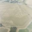
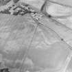
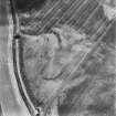
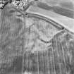
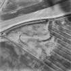
Aerial photography (RCAHMSAP 1995) has identified the cropmarks of a possible pit-defined enclosure and pits 120m SE of Farm of Forteviot (NO01NE 122). At least twelve pits form what may be an oval or sub-rectangular shaped enclosure measuring at least 42m by 35m, and pits are scattered across the immediate surrounding area. An arc of ditch, and other indeterminate cropmarkings, many of them probably geological in origin, are visible immediately to the south of the enclosure.
Information from RCAHMS (KB) 8 June 1999
Excavation (11 September 2007 - 22 September 2007)
NO 0550 1740 Excavation was undertaken between 11–22 September 2007 over the site of the Pictish Cemetery to the S of Forteviot village in September as part of the SERF project. The field lies to the SE of the village, two fields E of the Neolithic cropmark complex. The cemetery is represented by an extensive range of cropmark features including a large square enclosure, a series of round and square barrows, a number of dug graves, linear features and pit settings. Transcriptions of these features by RCAHMS guided the location of the excavation. The excavation targeted the location of two conjoined square barrows at the southern end of the cropmark distribution. The barrows were overlain by a variety of ploughmarks, probable furrows and more modern ploughmarks. A 17th-century coin and more modern finds were found in a buried ploughsoil overlying
the eastern barrow and the flat graves in the eastern side of the trench. The two barrows were defined by seven linear ditches and shared a common N–S ditch. The ditches were up to 0.3m in depth and contained two fills. The ditches had rounded ends with small gaps at the corners of the barrows.
The layout of the barrows was not entirely regular and suggests that the western barrow was primary with the eastern being added at a later date. In the western barrow there were two large postholes towards the middle of the W side, which were packed with large quartz nodules. The W ditch of the W barrow also contained a possible posthole setting. The W barrow had a central W/E grave, which was set in a square setting defined
by four small postholes on a similar orientation to the barrow ditches. The only human remains were teeth which were found at the W end of the grave.
The eastern barrow also had a central W/E grave with four postholes arranged around the grave. A group of human teeth was found at the W end of the burial.
To the NE of the barrows at least eight W/E graves were identified. These were oriented on the barrows and appeared to be organised into rows. Among these graves were two small, presumably child, graves. Five were excavated, two of which had human teeth surviving in the W ends.
At the end of the excavation coloured gravel was placed in backfilled features to monitor the impact of ploughing on the site.
www.gla.ac.uk/departments/archaeology/research/projects/serf
Archive currently deposited with the Department of Archaeology, University of Glasgow.
Funder: British Academy, Historic Scotland, Department of Archaeology University of Glasgow, Society of Antiquaries of Scotland.
Excavation (2009)
NO 0537 1739 A further area (50 x 15m) of the Pictish cemetery was opened up about 40m to the N of the 2007 excavations (DES 2007, 158). The aims of the excavation were to investigate a round barrow and an enigmatic square enclosure identified on aerial photographs. The whole area was truncated by modern deep ploughing and medieval strip cultivation.
In the western part of the trench, the round barrow contained a central E–W grave, with the remains of charred wooden planks or branches upright in the fill, but no skeletal remains survived. To the N was a smaller grave,
child-sized, oriented ENE–WSW, again with no skeletal remains. A posthole at the W end of the barrow enclosure may represent a grave marker. To the E a much deeper rectangular E–W grave-pit contained the decayed remains of a wooden coffin, part of which was charred. In section this was clearly a log coffin, but why it was charred remains to be investigated. A few fragments of tooth enamel survived at the head end. There were no contemporary artefacts in any of these features. Cutting the barrow ditch was a line of six postholes, which may relate to medieval/post-medieval agricultural activities.
In the eastern part of the trench, the square enclosure ditch was sectioned in five places, revealing a V-shaped flat-bottomed ditch c2m wide and up to 0.9m deep. The enclosure turned out to be an exact square, measuring 31m externally. There were indications of an internal bank, now completely ploughed out. If an entrance existed, it must have lain in the unexcavated part of the western perimeter. About one third of the interior was excavated, but there was no convincing evidence of structures. In the interior there were a number of pits of varying character and size, some filled with pebbles, others with burnt material, including a possible burnt wooden box. These formed no coherent patterns, and were interpreted as possible ritual deposits associated with cremation activities. A few pieces of Roman pottery were found in unstratified contexts throughout the trench. All ditch fills were remarkably clean, with no indication of settlement activities in the enclosure. The enclosure is unusual for the Scottish Iron Age in being exactly square. The only other parallel is at Cuiltburn, 15km W of Forteviot, which was dated to the 1st/2nd centuries AD. The Forteviot enclosure is possibly of this date and may have formed a focus for the Pictish cemetery.
Archive: University of Glasgow and RCAHMS (intended)
Funder: Historic Scotland, University of Glasgow and University of Aberdeen
Ewan Campbell and Meggen Gondek – SERF Project, Departments of Archaeology, Universities of Glasgow and Aberdeen
Excavation (2 August 2010 - 22 August 2010)
NO 0547 1685 Excavations from 2–22 August 2010 explored
two conjoined ‘Pictish’ square barrows, c0.5km S of the
northern cemetery (NO01NE 169), located just outside the
line of the prehistoric palisaded enclosure (NO01NE 28).
Unlike the square barrows explored in the northern cemetery
by SERF in 2007 these examples were almost half as small, at
around 5msq and, most notably, they did not have causeways
at the corners of their ditches.
Defined by a continuous ditch, the barrow to the W was
not a true square. The E (slightly smaller and squarer)
barrow appears to have been added at a later date. Although
these barrows have yet to be dated, their form suggests
they are early. Despite very poor preservation both central
burials yielded traces of wooden coffins, possibly log burials.
Both burials also produced remains of outer tooth enamel
from the inhumation. Rounded stones along the edge of the
western grave cut suggest the coffin was packed with stones.
A geophysical survey was conducted prior to the excavation.
The ditches of the square barrows were not identified, but the
central grave of the W barrow did correlate to an anomaly.
Archive: Currently University of Glasgow and RCAHMS (intended)
Funder: Historic Scotland, University of Glasgow and University of
Aberdeen

