Accessibility

Font Size

100% 150% 200%

Background Colour

Default Contrast
Close Reset

Wester Fintray

Enclosure (Period Unknown), Field System (Prehistoric), Pit(S) (Period Unknown), Pit Alignment (Prehistoric), Ring Ditch(S) (Prehistoric)

Site Name Wester Fintray

Classification Enclosure (Period Unknown), Field System (Prehistoric), Pit(S) (Period Unknown), Pit Alignment (Prehistoric), Ring Ditch(S) (Prehistoric)

Canmore ID 144401

Site Number NJ81NW 76

NGR NJ 807 161

NGR Description Centred NJ 807 161

Datum OSGB36 - NGR

Permalink http://canmore.org.uk/site/144401

Ordnance Survey licence number AC0000807262. All rights reserved.
Canmore Disclaimer. © Bluesky International Limited 2025. Public Sector Viewing Terms

Toggle Aerial | View on large map

Digital Images

Oblique aerial view centred on the cropmarks of an enclosure, ring ditches, field system and pits at Wester Fintray, looking to the SW.
Oblique aerial view centred on the cropmarks of an enclosure, ring ditches, field system and pits at Wester Fintray, looking to the SW.Oblique aerial view centred on the cropmarks of an enclosure, ring ditches, field system and pits at Wester Fintray, looking to the SSW. 

Oblique aerial view centred on the cropmarks of an enclosure, ring ditches, field system and pits at Wester Fintray, looking to the NNW.Oblique aerial view centred on the cropmarks of an enclosure, ring ditches, field system and pits at Wester Fintray, looking to the NW.Oblique aerial view centred on the cropmarks of an enclosure, ring ditches, field system and pits at Wester Fintray, looking to the NNE.General oblique aerial view centred on the cropmarks of a palisaded enclosure, ring ditches, field system and pits at Wester Fintray, looking to the NW.Oblique aerial view centred on the cropmarks of a possible palisaded enclosure, field system, ring-ditches, pits and rig at Suttie and Wester Fintray, looking to the ENE.Oblique aerial view centred on the cropmarks of an enclosure, ring ditches, field system and pits at Wester Fintray, looking to the SSW.Oblique aerial view centred on the cropmarks of an enclosure, ring ditches, field system and pits at Wester Fintray, looking to the NNE.Oblique aerial view centred on the cropmarks of an enclosure, ring ditches, field system and pits at Wester Fintray, looking to the NE.Oblique aerial view centred on the cropmarks of an enclosure, ring ditches, field system and pits at Wester Fintray, looking to the S.Oblique aerial view centred on the cropmarks of the palisaded enclosure, pits and rig at Suttie, looking to the NNW.Oblique aerial view centred on the cropmarks of an enclosure, ring ditches, field system and pits at Wester Fintray, looking to the SW.Oblique aerial view centred on the cropmarks of an enclosure, ring ditches, field system and pits at Wester Fintray, looking to the ESE.Oblique aerial view centred on the cropmarks of an enclosure, ring ditches, field system and pits at Wester Fintray, looking to the SSW. 

Oblique aerial view centred on the cropmarks of an enclosure, ring ditches, field system and pits at Wester Fintray, looking to the NNE.Oblique aerial view centred on the cropmarks of the palisaded enclosure, pits and rig at Suttie, looking to the NNW.

Administrative Areas

  • Council Aberdeenshire
  • Parish Fintray
  • Former Region Grampian
  • Former District Gordon
  • Former County Aberdeenshire

Archaeology Notes

NJ81NW 76 centred 807 161

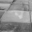
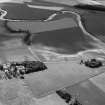
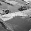
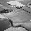
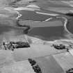
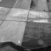
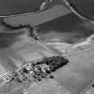
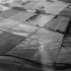
Wester Fintray. Air photography (AAS/82/13/R16/14 and AAS/82/14/R20/28-30) has recorded cropmarks (including those of ring-ditches, a field-system, a pit-alignment and other pits) in arable ground at an altitude of between 50 and 55m OD.

NMRS, MS/712/77.

References

MyCanmore Image Contributions


Contribute an Image

MyCanmore Text Contributions