
Pricing Change
New pricing for orders of material from this site will come into place shortly. Charges for supply of digital images, digitisation on demand, prints and licensing will be altered.
Knocknagael, Boar Stone


Pictish Symbol Stone (Pictish)
Site Name Knocknagael, Boar Stone
Classification Pictish Symbol Stone (Pictish)
Alternative Name(s) Knocknagael Boar Stone; Boarstone; Drumdevan
Canmore ID 13507
Site Number NH64SE 25
NGR NH 6567 4134
Datum OSGB36 - NGR
Permalink http://canmore.org.uk/site/13507


- Council Highland
- Parish Inverness And Bona
- Former Region Highland
- Former District Inverness
- Former County Inverness-shire
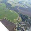
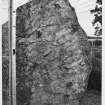
Knocknagael, Inverness-shire, Pictish symbol stone
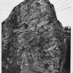
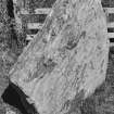
Measurements: H 2.06m +, W 2.18m, D 0.36
Stone type: slate
Place of discovery: c NH656 413
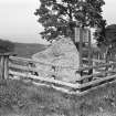
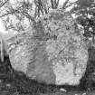
Present location: in the foyer of Highland Council Headquarters, Glenurquhart Road, Inverness.
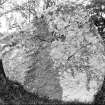
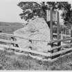
Evidence for discovery: in the mid nineteenth century it stood in a field on Knocknagael Farm, and it was subsequently moved to the edge of the field, close to the road. In 1991 it was taken to its present location in Inverness.
Present condition: good.
Description
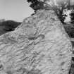
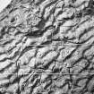
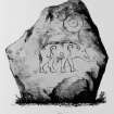
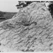
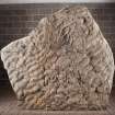
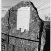
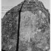
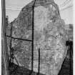
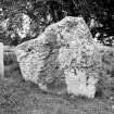
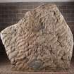
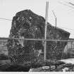
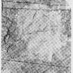
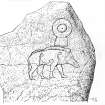
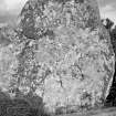
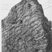
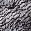
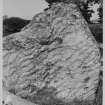
This large irregularly shaped slab bears on one broad face two incised Pictish symbols: a disc and rectangle (or ‘mirror-case’), and close below it a very finely delineated boar. The boar paces towards the right, bristles erect along his back, with well-drawn spiral joints.
Date: seventh century.
References: Stuart 1856, pl 18; ECMS pt 3, 103-5; Fraser 2008, no 113.
Compiled by A Ritchie 2017
Field Visit (14 August 1943)
Sculptered Stone, Drumdevan.
This stone, which stands on the E side of the Inverness-Loch Ashie road about 200 yds of Drumdevan, has been described but without a photograph (Cf. ECM, iii, 104). These have now been secured by Professor Childe. The stone measures 6ft 7in in height, 7ft in breadth and 1ft 3in in thickness. Axis of face is nearly ENE and WSW.
Visited by RCAHMS 14 August 1943.
Field Visit (22 March 1962)
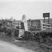
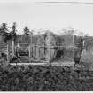
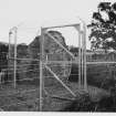
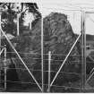
This large, upright, sculptured stone is as described above. A MoW. plaque at the side describes this "The Knocknagael Boarstone" - 5th - 8th century AD. Pictish symbol stone. It is protected by a high wire fence.
Visited by OS (JLD), 22 March 1962.
Field Visit (June 1978)
Knocknagael Boar's Stone, Symbol Stone NH 656 413 NH64SE 25
A Class I 'Pictish' symbol stone, which stands on the E side of the Inverness to Essich road, bears boar and mirror-case symbols.
RCAHMS 1979, visited June 1978
Allen and Anderson 1903, iii, 103-5
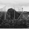
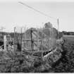
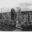
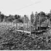
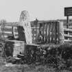
Excavation (1994)
Excavation was undertaken around the stone prior to its removal to its new protected location (supra). The work was limited to the small Guardianship area, and was further reduced by the immense disturbance caused by the fence foundations. Guardianship gravel overlay a layer of blackened cobbles which dipped below the stone itself. Both were rich in glass and pottery fragments of recent date. and probably derived from the local pashme of hurling bottles at the stone from passing cars. Beneath this was natural gravel subsoil, and it was clear that the stone was not on its original site. Two finds of interest, both unstratified. were noted. These consisted of a small, unretouched and undiagnostic flint flake and a broken glass bead of recent date. Neither relate to the stone.
Highland Regional Council 1994.
Reference (1997)
Class I symbol stone bearing a boar surmounted by a mirror-case.
A Mack 1997.
Watching Brief (15 December 2009)
NH 6534 3834 – NH 6569 3925 – NH 6505 3897 An ongoing
programme of archaeological work began on 15 December
2009 in relation to the construction of a substation at
Knocknagael. The construction of passing places on a
single track road was the subject of eight watching briefs
and excavations for site compounds, access and haul roads,
new electricity towers and cable routes were all subject to a
controlled topsoil strip. The extensive trial pits excavated in
the c8.9ha substation site were the subject of a controlled
topsoil strip. A further 24 archaeological trial trenches were
also excavated.
Apart from one localised, rubble-filled field drain, the
whole area proved to be remarkably clear of archaeology. A
total of five shallow features were identified on the substation
site. These were recorded as possible postholes, but were
probably formed by root action and/or the burning of gorse.
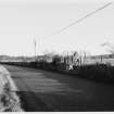
The public road serving the site follows the line of General
Wade’s military road between Inverness and Fort Augustus,
built in 1726. The first passing space constructed lies close
to the former site of the Knocknagael Boar Stone, which was
moved to the Highland Council’s headquarters in 1990. It
is shown on this site on the 1st Edition OS map of 1875,
but an excavation at the time of its removal noted that it
was standing on disturbed ground and it seems to have been
placed there in the 19th century. No archaeological features
or finds were found during the watching brief on the passing
space or observed during topsoil stripping for a nearby cable.
Archive: Highland Archaeology Services Ltd
Funder: Scottish and Southern Energy
External Reference (23 December 2010)
(Former Index no. 90197). Descheduled.
Information from Historic Scotland, Certificate of Exclusion from Schedule dated 23 December 2010.
Desk Based Assessment
NH64SE 25 6567 4134
(NH 6567 4134) Boar's Stone {NR} (Sculptured)
OS 6" map, Inverness-shire, 2nd ed., (1906).
See also NH64SE 64.
Knocknagael Boar Stone: A roughly shaped slab. At the top is incised the mirror-case symbol and below the figure of a wild boar. The round part of the mirror case is ornamented with a circle and a central dot and the boar has spiral curves on the body.
V G Childe and W D Simpson 1954.
Full description of Stone. Height 6' 9"; breadth 7' 2"; thickness 1' 1 1/2". Metric dimensions - 2m x 2.2m x 0.31m.
W Jolly 1882; J Stuart 1856; J R Allen and J Anderson 1903; D Butler 1926.
Information from OS.
Note
Transferred March 1991 to foyer of Highland Regional Council Chambers, Glenurquhart Road, Inverness (NH64SE 64).
(Undated) information in NMRS.

