
Tulliemet Burn


Corn Drying Kiln (Period Unassigned), Farmstead (Period Unassigned), Lime Kiln (Period Unassigned)
Site Name Tulliemet Burn
Classification Corn Drying Kiln (Period Unassigned), Farmstead (Period Unassigned), Lime Kiln (Period Unassigned)
Alternative Name(s) Leakinauchnahoishir
Canmore ID 131891
Site Number NO05NW 18
NGR NO 0222 5578
Datum OSGB36 - NGR
Permalink http://canmore.org.uk/site/131891


- Council Perth And Kinross
- Parish Logierait
- Former Region Tayside
- Former District Perth And Kinross
- Former County Perthshire
NO05NW 18 0222 5578
A farmstead comprising three unroofed buildings, and a lime kiln are depicted on the 1st edition of the OS 6-inch map (Perthshire 1867, sheet xli). Four unroofed buildings, one of which is T-shaped and another is in the same location as the lime kiln, are shown on the current edition of the OS 1:10000 map (1977).
Information from RCAHMS (SAH) 5 December 1997.
Photographic Record (25 July 2008 - 25 July 2008)
Various views of site
Field Visit (25 July 2008 - 25 July 2008)
Sketch plan of site
Srp Note (27 November 2008)
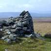
This farmstead is located on open moorland at 390m OD. To its immediate NE is an area of better ground which may have been cultivated in the past, being generally greener than the land surrounding it. The site comprises three rectangular buildings and a kiln, arranged around a yard. The first building has three compartments and measures approximately 22.9m by 5m overall; the second has three compartments and measures 18.6m by 3.6m overall; the third is a single compartment building and measures 13.9m by 7.7m overall. The kiln is the best preserved structure on the site, standing up to 2m in height.

