
Voydale, Skara Brae Visitor Centre


Visitor Centre (20th Century)
Site Name Voydale, Skara Brae Visitor Centre
Classification Visitor Centre (20th Century)
Alternative Name(s) Skaill
Canmore ID 123654
Site Number HY21NW 41
NGR HY 23469 18758
NGR Description HY 23469 18758 and HY 2345 1875
Datum OSGB36 - NGR
Permalink http://canmore.org.uk/site/123654


- Council Orkney Islands
- Parish Sandwick
- Former Region Orkney Islands Area
- Former District Orkney
- Former County Orkney
HY21NW 41 23469 18758
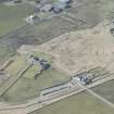
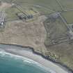
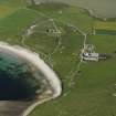
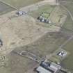
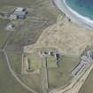
Late 20th century visitor centre for the World Heritage prehistoric Skara Brae site.
Semi-circular in plan situated at Voydale 153m NNE of Skaill House (HY21NW 17), incorporates a restaurant, cafe and bookshop/ticket office. Car park with connecting road to SE.
Information from RCAHMS (DE), March 2009
Archaeological Evaluation (1997)
HY 2345 1875 Prior to the construction of a new visitor centre for Skara Brae, an archaeological evaluation and watching brief was undertaken of all areas likely to be affected by the enabling works.
Five of the trenches contained evidence for collapsed stone walls at a depth of 1-1.8m below sterile windblown sand. Three of these walls, which showed evidence of clay bonding, were interpreted as field boundaries, although an associated old ground surface was not identified.
A drain leading from an upstanding circular structure (a possible 19th-century lint mill) was also identified, but samples taken from its fill did not contain any plant microfossils which could have confirmed its function.
Sponsor: Historic Scotland
H F James 1997
Orkney Smr Note (1998)
Further watching briefs during the digging of the foundation trenches for the visitor centre and service trenches were undertaken by OAT in August 1997 and March 1998. These recorded the remains of field dykes and features associated with industrial archaeology. Most notable were a stone well or sump and a wooden channel.
Information from Orkney SMR (M L Webb) 1998

