|
Photographs and Off-line Digital Images |
A 135 |
Dr Joanna Close-Brooks |
Dr J Close-Brooks |
1984 |
Item Level |
|
|
Photographs and Off-line Digital Images |
A 136 |
Dr Joanna Close-Brooks |
Dr J Close-Brooks |
1984 |
Item Level |
|
|
Photographs and Off-line Digital Images |
A 137 |
Dr Joanna Close-Brooks |
Dr J Close-Brooks |
1984 |
Item Level |
|
|
Photographs and Off-line Digital Images |
A 138 |
Dr Joanna Close-Brooks |
Dr J Close-Brooks |
1984 |
Item Level |
|
|
Photographs and Off-line Digital Images |
A 139 |
Dr Joanna Close-Brooks |
Dr J Close-Brooks |
1984 |
Item Level |
|
 |
Digital Files (Non-image) |
WP 000775 |
Records of the Royal Commission on the Ancient and Historical Monuments of Scotland (RCAHMS), Edinbu |
Scanned copy of RCAHMS Marginal Land Survey unpublished typescripts (Inverness-shire). |
1954 |
Item Level |
|
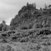 |
On-line Digital Images |
SC 1367560 |
|
General view of Torr Dhuin, fort. |
1984 |
Item Level |
|
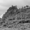 |
On-line Digital Images |
SC 1367561 |
|
General view of Torr Dhuin, fort. |
1984 |
Item Level |
|
 |
On-line Digital Images |
SC 1367562 |
|
General view of Torr Dhuin, fort. |
1984 |
Item Level |
|
|
Digital Files (Non-image) |
GV 006053 |
Records from Headland Archaeology Ltd, archaeologists, Edinburgh, Scotland |
Map showing the locations of the five forts, illustration 1 from a report on a topographic archaeological survey at five Pictish Forts in the Highlands |
9/2010 |
Item Level |
|
|
Digital Files (Non-image) |
GV 006057 |
Records from Headland Archaeology Ltd, archaeologists, Edinburgh, Scotland |
Plan of Torr Dhuin at 1:250, illustration 16 from a report on a topographic archaeological survey at five Pictish Forts in the Highlands |
9/2010 |
Item Level |
|
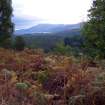 |
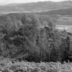
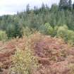
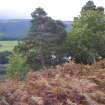
On-line Digital Images |
DP 230853 |
Records from Headland Archaeology Ltd, archaeologists, Edinburgh, Scotland |
View towards Fort Augustus from Torr Dhuin, from a topographic archaeological survey at five Pictish Forts in the Highlands |
9/2010 |
Item Level |
|
 |
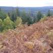
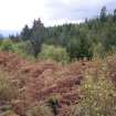
On-line Digital Images |
DP 230854 |
Records from Headland Archaeology Ltd, archaeologists, Edinburgh, Scotland |
View towards north end of fort, photograph of Torr Dhuin, from a topographic archaeological survey at five Pictish Forts in the Highlands |
9/2010 |
Item Level |
|
 |
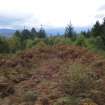
On-line Digital Images |
DP 230855 |
Records from Headland Archaeology Ltd, archaeologists, Edinburgh, Scotland |
View of west rampart, photograph of Torr Dhuin, from a topographic archaeological survey at five Pictish Forts in the Highlands |
9/2010 |
Item Level |
|
 |
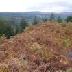
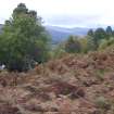
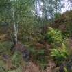
On-line Digital Images |
DP 230856 |
Records from Headland Archaeology Ltd, archaeologists, Edinburgh, Scotland |
View towards Inchnacardoch Forest from the fort, photograph of Torr Dhuin, from a topographic archaeological survey at five Pictish Forts in the Highlands |
9/2010 |
Item Level |
|
 |
On-line Digital Images |
DP 230857 |
Records from Headland Archaeology Ltd, archaeologists, Edinburgh, Scotland |
Rampart at north west corner of fort, photograph of Torr Dhuin, from a topographic archaeological survey at five Pictish Forts in the Highlands |
9/2010 |
Item Level |
|
 |
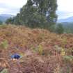
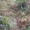
On-line Digital Images |
DP 230858 |
Records from Headland Archaeology Ltd, archaeologists, Edinburgh, Scotland |
Ditch running across the fort interior, photograph of Torr Dhuin, from a topographic archaeological survey at five Pictish Forts in the Highlands |
9/2010 |
Item Level |
|
 |
On-line Digital Images |
DP 230859 |
Records from Headland Archaeology Ltd, archaeologists, Edinburgh, Scotland |
View of fort interior from the north, photograph of Torr Dhuin, from a topographic archaeological survey at five Pictish Forts in the Highlands |
9/2010 |
Item Level |
|
 |
On-line Digital Images |
DP 230860 |
Records from Headland Archaeology Ltd, archaeologists, Edinburgh, Scotland |
East rampart, photograph of Torr Dhuin, from a topographic archaeological survey at five Pictish Forts in the Highlands |
9/2010 |
Item Level |
|
 |
On-line Digital Images |
DP 230861 |
Records from Headland Archaeology Ltd, archaeologists, Edinburgh, Scotland |
View towards the Caledonian Canal from the fort, photograph of Torr Dhuin, from a topographic archaeological survey at five Pictish Forts in the Highlands |
9/2010 |
Item Level |
|
 |
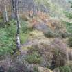
On-line Digital Images |
DP 230862 |
Records from Headland Archaeology Ltd, archaeologists, Edinburgh, Scotland |
Sunken path leading up to the fort through ramparts, photograph of Torr Dhuin, from a topographic archaeological survey at five Pictish Forts in the Highlands |
9/2010 |
Item Level |
|
 |
On-line Digital Images |
DP 230863 |
Records from Headland Archaeology Ltd, archaeologists, Edinburgh, Scotland |
View along ditch and outer rampart, photograph of Torr Dhuin, from a topographic archaeological survey at five Pictish Forts in the Highlands |
9/2010 |
Item Level |
|
 |
On-line Digital Images |
DP 230864 |
Records from Headland Archaeology Ltd, archaeologists, Edinburgh, Scotland |
View along bank along cliff edge to the south of fort, photograph of Torr Dhuin, from a topographic archaeological survey at five Pictish Forts in the Highlands |
9/2010 |
Item Level |
|
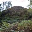 |
On-line Digital Images |
DP 230865 |
Records from Headland Archaeology Ltd, archaeologists, Edinburgh, Scotland |
Fort seen from the north west, photograph of Torr Dhuin, from a topographic archaeological survey at five Pictish Forts in the Highlands |
9/2010 |
Item Level |
|


