
Collieston


Village (Period Unassigned)
Site Name Collieston
Classification Village (Period Unassigned)
Alternative Name(s) Collestowne; High Town; Kirkton Of Slaines; Low Town
Canmore ID 118553
Site Number NK02NW 32
NGR NK 03925 28520
NGR Description Centred NK 03925 28520
Datum OSGB36 - NGR
Permalink http://canmore.org.uk/site/118553


- Council Aberdeenshire
- Parish Slains
- Former Region Grampian
- Former District Gordon
- Former County Aberdeenshire
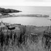
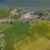
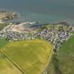
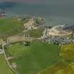
Collieston Harbour, 1894. Aberdeenshire's only formal link to the sea, angle granite pier and quayed shore; notable for
'tunnel piercing foundations of break-water-pier near the present end of its walkway, evidently designed for the flushing-out of silt like those recommended by Smeaton (1770) at Dundee' (A Graham). In 1696, 36 fishermen lived in 'Collestowne', one of the largest fishing communities north of the Tay; by the 1880s, there were over 100 fishing for 'prodsing speldins' (dried haddock) or 'blauvin fishies' (whiting), yet the community moved, almost wholesale, c.1900, to Torry as a result of 'the stone', an incurable malady. The Lang Reel o'Collieston used to be danced by the whole community on Forvie Sands after each fisher wedding.
Taken from "Aberdeenshire: Donside and Strathbogie - An Illustrated Architectural Guide", by Ian Shepherd, 2006. Published by the Rutland Press http://www.rias.org.uk

NK02NW 32 centred 03925 28520
Location formerly entered as NK 039 285.

