
Following the launch of trove.scot in February 2025 we are now planning the retiral of some of our webservices. Canmore will be switched off on 24th June 2025. Information about the closure can be found on the HES website: Retiral of HES web services | Historic Environment Scotland
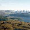
Ob Na Leobag, Totaig


Wheelhouse (Iron Age)
Site Name Ob Na Leobag, Totaig
Classification Wheelhouse (Iron Age)
Canmore ID 11816
Site Number NG82NE 23
NGR NG 870 254
Datum OSGB36 - NGR
Permalink http://canmore.org.uk/site/11816


- Council Highland
- Parish Glenshiel
- Former Region Highland
- Former District Skye And Lochalsh
- Former County Ross And Cromarty
NG82NE 23 870 254.
The structure occupies the E shoreward end of the small grass-grown rock peninsula that partly encloses Ob na Leobag, and is a complex of overgrown earth and stone banks generally some 1m wide by 0.4m high. A roughly circular uneven grass-grown central area some 5.6m in diameter is surrounded by eight cells and a gateway corridor. The cells are open to the central area and are some 4m long over the bank forming the outer, circular perimeter of the site, overall diameter c. 14m. On the E side a roughly cobbled and stepped path enters from the peninsula neck. On the N side the outer ends of some of the cells have been eroded by wave action from the open loch. On the S, bay side of the site, and elsewhere along the bay side of the peninsula are stretches of dry-stone revetting.
W Lonie 1982.

