
Raasay, Raasay House


Cross Incised Rock (Early Medieval)
Site Name Raasay, Raasay House
Classification Cross Incised Rock (Early Medieval)
Alternative Name(s) Churchton Bay; Raasay 2
Canmore ID 11474
Site Number NG53NW 2
NGR NG 5455 3631
Datum OSGB36 - NGR
Permalink http://canmore.org.uk/site/11474


- Council Highland
- Parish Portree
- Former Region Highland
- Former District Skye And Lochalsh
- Former County Inverness-shire
Raasay 2, Skye & Lochalsh, cross-incised rock-face
Measurements: cross and shaft H 1.09m, W of cross-head 0.52m
Stone type: sandstone
Place of discovery: NG 5455 3631
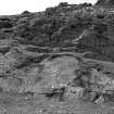
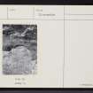
Present location: on a south-east facing slope of the rock outcrop which divides Churchton Bay.
Evidence for discovery: this was probably the cross seen in 1773 by Boswell.
Present condition: weathered but the carving is clear.
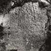
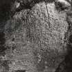
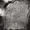
Description
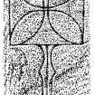
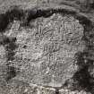
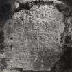
Incised on a naturally smooth rock-face is a cross-of-arcs within a square frame, set on a cusped shaft with an inner vertical line. The cross-head has equal expanded arms, and there is a chi-rho scroll attached to the right-hand side of the upper arm.
Date range: seventh century.
Primary references: Richardson 1907, 435-6; Fisher 2001, 103.
Compiled by A Ritchie 2016
Field Visit (22 May 1914)
Cross on Rock, Old Pier, Island of Raasay.
On a sloping rock facing the south-east, immediately to the west of a shed on the south side of the old pier at Raasay and about 9 feet above high-water mark, is an incised cross 3 feet 7 inches in length. The head o fthe cross is formed by four intersecting curves within a square, the sides of which are 20 inches in length, and the shaft, 23 inches in length and 2½ inches in breadth for the greater part of its length, is composed of a medial line between two marginal lines. These outer lines are 5 inches apart at the top of the shaft and curve inwardly to a width of 3 inches, then outwards to a width of 6 inches at a distance of 7 inches from the head, after which they contract again to a width of 2¼ inches and finally converge at the base.
See Proc. Soc. Ant. Scot., XLI., p. 435.
RCAHMS 1928, visited 22 May 1914.
OS map: Skye xxxv.
Field Visit (1997)
Site recorded during an archaeological assessment undertaken in September 1997 in advance of a proposed new ferry terminal.
NG 5455 3631 Cross-incised stone.
A report will be lodged with the NMRS.
Sponsor: Highland Council.
K Cameron 1997
Reference (2001)
A Chi-rho cross is incised on the E face of the sandstone outcrop that divides the two halves of Churchton Bay and which soon after 1800 was converted into a battery.(i) The pier of the same period lies to the W of the outcrop, and the rock-carving may have been the 'cross, or rather the ruins of one, upon a rock' which Boswell observed close to the rocks on which he and Johnson landed in 1773.(ii) The lower part of the outcrop includes a steeply-sloping but fairly regular surface, about 5m long and 3m high, on which the cross is carved.
The cross is similar to but larger than that on the symbol-stone, having a frame 0.52m square for the cross-of-arcs and a shaft 0.57m high, and the foot of the shaft is about 1.4m above present ground level. There are several vertical cracks in the upper part of the rock-face, and one of these was incorporated in the right side of the frame. The arms of the cross lack the inner triangles of that on the symbol-stone, and they intersect without any circular boss. The top of the cusped shaft curves out to form a broader base for the cross, and it has an axial groove which terminates just above the rounded foot to give the effect of a double band.
NMS cast, X.IB 224; RCAHMS 1928, No.581; J S Richardson 1907, 435-6; PSAS, 67 (1932-3), 64; J J Galbraith 1933, 318-20; R Sharpe 1977, 21-5.
(i) R Sharpe 1977, 44.
(ii) F A Pottle and C H Bennett 1963, 132. Elsewhere he described, 'rudely drawn a square with a crucifix in the middle', and made a sketch (ibid., 141-2).
I Fisher 2001.
External Reference (2011)
This cross-incised stone and the cross slab with Pictish symbols found nearby (MHG5726) exemplify the earliest phase of the interface between cross and symbol (Henderson & Henderson 2006, 174).
Information from the ARCH Community Timeline course, 2011
Desk Based Assessment
NG53NW 2 5455 3631.
NG 5455 3631 Cross (NR)
OS 6" map, Inverness-shire, 2nd ed., (1904)
On a sloping rock facing SE, immediately to the W of a shed on the S side of the old pier at Raasay and about 9' above high-water mark, is an incised Chi-Rho cross 3'7" in length. The head of the cross is formed by four intersecting curves within a square, the sides of which are 20" in length, and the shaft, 23 " in length and 2 1/2" in breadth for the greater part of its length is composed of a medial line between two marginal lines. Nearby was found a Pictish symbol stone bearing a similarly incised cross (RCAHMS 1928; PSAS 1907) (NG53NW 3). Crosses of this type are dated by Curle (C L Curle 1940) to the second half of the 7th century, but see Radford (C R Radford 1942) and Stevenson (R B K Stevenson 1955) who criticise this paper, and Galbraith (1933) who gives a second half of the 6th century date on the suggestion that it is connected with St. Moluag's mission to Raasay. It is mentioned by Boswell (F A Pottle and C H Bennett 1963) as the place where the Macleods of Raasay practised their devotions and noted by him as one of the St. Maol-luags sanctuary markers (q.v. NG53NW 4).
Information from OS.
Name Book; Proc Soc Antiq Scot 1907; C L Curle 1940; C R Radford 1942; R B K Stevenson 97-128; F A Pottle and C H Bennett 1963; J J Galbraith 1933.

