
North Berwick, Swimming Pool


Swimming Pool (Period Unassigned)
Site Name North Berwick, Swimming Pool
Classification Swimming Pool (Period Unassigned)
Alternative Name(s) Kirk Ness; North Berwick Harbour
Canmore ID 113617
Site Number NT58NE 54
NGR NT 55394 85661
Datum OSGB36 - NGR
Permalink http://canmore.org.uk/site/113617


- Council East Lothian
- Parish North Berwick
- Former Region Lothian
- Former District East Lothian
- Former County East Lothian
NT58NE 54 55394 85661
See also NT58NE 22.
Location formerly entered in error as NT 5553 9566.
Not to be confused with paddling pool at NT 55497 85529, for which see NT58NE 193.
Site recorded during a rapid coastal survey undertaken by GUARD of the S shore of the Firth of Forth from Dunbar to Stirling and along the N shore of the Forth to the Fife border. A gazetteer of all sites including listed buildings, designed landscapes, scheduled and unscheduled monuments was produced. Full details of the survey can be consulted in the report held by the NMRS.
GUARD 1996
Site recorded from draft text of Discovery and Excavation in Scotland 1996 (ref: 96/580), held by Council for Scottish Archaeology.
CSA 1996
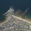
A large outdoor swimming pool complex on Kirk Ness promontory in North Berwick. The complex is of brick and concrete construction, there is seating on the north, east and west sides around a rectangular sloping pool. There are single cubicle changing rooms on the south and east sides and a diving platform on the south side. The entire pool area is surrounded with the metal skeleton of a fence or wind break. To the south-east of the pool area is a leisure centre and cafe. The entire leisure complex is now abandoned and is subject to minor vandalism. It does not appear to be maintained and the pool area is filling with seaweed and sand.
Site recorded by GUARD during the Coastal Assessment Survey for Historic Scotland, 'The Firth of Forth from Dunbar to the Coast of Fife' 18th February 1996.
Field Visit (1996)
Site recorded during a rapid coastal survey undertaken by GUARD of the S shore of the Firth of Forth from Dunbar to Stirling and along the N shore of the Forth to the Fife border. A gazetteer of all sites including listed buildings, designed landscapes, scheduled and unscheduled monuments was produced. Full details of the survey can be consulted in the report held by the NMRS.
GUARD 1996

