
Following the launch of trove.scot in February 2025 we are now planning the retiral of some of our webservices. Canmore will be switched off on 24th June 2025. Information about the closure can be found on the HES website: Retiral of HES web services | Historic Environment Scotland
Wester Hatton


Sand And Gravel Extraction Site (Period Unknown)
Site Name Wester Hatton
Classification Sand And Gravel Extraction Site (Period Unknown)
Canmore ID 111682
Site Number NJ91NE 35
NGR NJ 9576 1561
Datum OSGB36 - NGR
Permalink http://canmore.org.uk/site/111682


- Council Aberdeenshire
- Parish Belhelvie
- Former Region Grampian
- Former District Gordon
- Former County Aberdeenshire
NJ91NE 35 9576 1561
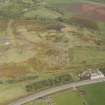
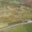
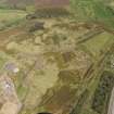
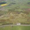
Vertical aerial photography (OS 82/162/035) has recorded a roughly circular cropmark, possibly representing an old sand- or gravel-pit measuring about 17m in diameter, on a gentle SE-facing slope 70m NW of Wester Hatton farmhouse (NJ91NE 34.00). Although the cropmark is generally forms a solid disc, the SE (downhill) side is less well-defined, and there are two faceted edges on the N and NE.
Information from RCAHMS (JRS), 18 April 1996.

